
Ansbach district
| coat of arms | Germany map |
|---|---|

|

Coordinates: 49 ° 15 ' N , 10 ° 28' E |
| Basic data | |
| State : | Bavaria |
| Administrative region : | Middle Franconia |
| Administrative headquarters : | Ansbach |
| Area : | 1,971.84 km 2 |
| Residents: | 184,591 (Dec. 31, 2019) |
| Population density : | 94 inhabitants per km 2 |
| License plate : | AN , DKB, FEU, ROT |
| Circle key : | 09 5 71 |
| NUTS : | DE256 |
| Circle structure: | 58 municipalities |
| Address of the district administration: |
Crailsheimstrasse 1 91522 Ansbach |
| Website : | |
| District Administrator : | Jürgen Ludwig ( CSU ) |
| Location of the district of Ansbach in Bavaria | |
 .svg) |
|
The district of Ansbach in the administrative region of Middle Franconia is the largest district in Bavaria in terms of area . The independent city of Ansbach is completely surrounded by the district of Ansbach and at the same time its seat. The district is a member of the Nuremberg Metropolitan Region .
geography
location
The European watershed separates the watercourses to the large rivers Rhine and Danube from northwest to southeast of the district . The lowest point in the district is at Tauberzell ( 298 m above sea level ), the highest point is the Hesselberg at 689.4 m above sea level. NN .

In the north, the district is delimited by the Frankenhöhe ridge .

The Oettinger Forest marks the southern border of the district.

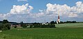
The Altmühl rises in the district of Ansbach (here the course of the river near Leutershausen ).
The village of Obermögersheim marks the border with the Weißenburg-Gunzenhausen district in the southeast.


Neighboring areas
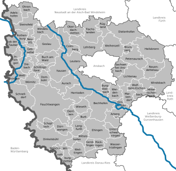
The district borders clockwise in the north, beginning with the districts Neustadt an der Aisch-Bad Windsheim , Fürth , Roth , Weißenburg-Gunzenhausen and Donau-Ries (all in Bavaria) as well as the districts Ostalbkreis , Schwäbisch Hall and Main-Tauber-Kreis ( all in Baden-Württemberg ).
history

Regional courts

Before 1800, the area of today's district of Ansbach belonged predominantly to the Principality of Ansbach , the imperial cities of Rothenburg ob der Tauber and Dinkelsbühl, as well as smaller areas of rule. In 1802 the area became part of Bavaria and the district court districts of Ansbach , Dinkelsbühl , Feuchtwangen , Heilsbronn , Herrieden , Leutershausen , Rothenburg and Wassertrüdingen as well as the Schillingsfürst district court emerged from which the Schillingsfürst district court emerged in 1840 . All judicial districts belonged from 1808 to the Rezatkreis (capital Ansbach) and from 1838 to Middle Franconia . The cities of Ansbach, Dinkelsbühl and Rothenburg ob der Tauber had become independent cities in 1809 and were therefore directly under the district administration.
District Offices
In 1862, the district office of Ansbach was formed from the merger of the district courts of the older order of Ansbach and Leutershausen . Likewise, the regional courts of Dinkelsbühl and Wassertrüdingen were combined to form the district office of Dinkelsbühl , the regional courts of Feuchtwangen and Herrieden to form the district office of Feuchtwangen, and the regional courts of Rothenburg and Schillingsfürst to form the district office of Rothenburg ob der Tauber . The cities of Ansbach, Dinkelsbühl and Rothenburg ob der Tauber did not belong to any district office.
The Heilsbronn District Office , which was formed in 1862 as a continuation of the Heilsbronn District Court, was split up on January 1, 1880 between the Ansbach, Gunzenhausen and Schwabach district offices. The district office of Ansbach ceded municipalities to the district offices of Rothenburg ob der Tauber and Uffenheim . In addition, the Rothenburg ob der Tauber district office received the Preuntsfelden community from the Uffenheim district office.
Counties
On January 1, 1939, as everywhere in the German Reich, the designation district was introduced. The district offices became the districts of Ansbach, Dinkelsbühl, Feuchtwangen and Rothenburg ob der Tauber.
The city of Dinkelsbühl was reassigned to the district of Dinkelsbühl on April 1, 1940, as was the city of Rothenburg ob der Tauber to the district of the same name, but in the case of Rothenburg this was reversed on April 1, 1948, while Dinkelsbühl did not regain district freedom.
On October 1, 1970, the city of Ansbach was enlarged to include the municipality of Eyb in the district.
On July 1, 1971, the district of Feuchtwangen was enlarged to include communities from the district of Dinkelsbühl.
Ansbach district
In the course of the regional reform in Bavaria , a new and larger district of Ansbach was formed on July 1, 1972
- the old district of Ansbach except for the communities Bernhardswinden , Brodswinden , Elpersdorf bei Ansbach , Hennenbach , Neuses bei Ansbach and Schalkhausen , which were incorporated into the city of Ansbach.
- the district of Dinkelsbühl
- the district of Feuchtwangen except for the community Claffheim , which was incorporated into the city of Ansbach
- the district of Rothenburg ob der Tauber except for the communities of Ermetzhof and Steinach an der Ens , which came to the district of Neustadt an der Aisch-Bad Windsheim
- the independent city of Rothenburg ob der Tauber
- the communities of Biederbach , Gerbersdorf , Hirschlach , Ismannsdorf , Merkendorf , Mitteleschenbach , Reutern , Selgenstadt and Wolframs-Eschenbach in the Gunzenhausen district
- the communities of Dietenhofen and Neudorf in the district of Neustadt an der Aisch and
- the municipalities of Hergersbach , Untereschenbach and Winkelhaid in the district of Schwabach .
On May 1, 1978 Bosacker joined the district of Nördlingen as part of the regional reform .
The district of Ansbach has been the largest district in Bavaria since then. Rothenburg ob der Tauber was given the status of a large district town due to the loss of district freedom . Ansbach was preserved as an independent city and became the seat of the new Ansbach district. On January 1, 1998, Dinkelsbühl was elevated to the status of a large district town because of its historical importance and the fact that it was independent until 1940.
Population development
From 1988 to 2008 the district of Ansbach grew by almost 23,000 inhabitants or around 14%. Since 2005 the trend towards a high of approx. 184,600 inhabitants. In the period from 1988 to 2018, the population rose from 158,695 to 183,949 by 25,254 inhabitants or 15.9%.
The following figures refer to the territorial status on May 25, 1987.
| year | 1840 | 1900 | 1939 | 1950 | 1961 | 1970 | 1987 | 1991 | 1995 | 2000 | 2005 | 2010 | 2015 |
|---|---|---|---|---|---|---|---|---|---|---|---|---|---|
| Residents | 111.153 | 116.024 | 117,077 | 168.909 | 149.022 | 155,809 | 157.632 | 168,373 | 178,265 | 183.207 | 183,755 | 179,925 | 181.314 |
politics
court House
Service building 1 of the District Office is located at Crailsheimstrasse 1 and service building 2 at Crailsheimstrasse 64 in the independent city of Ansbach. There are also seven branch offices in the district.
District administrators
- 1972–1990: Georg Ehnes ( CSU )
- 1990–2002: Hermann Schreiber (CSU)
- 2002–2012: Rudolf Schwemmbauer (CSU)
- 2012– : Jürgen Ludwig (CSU)
On March 25, 2012, Jürgen Ludwig (CSU) was elected to succeed Rudolf Schwemmbauer as district administrator with 60.27% of the vote. The election had become necessary because Schwemmbauer had asked the district council for an early release from the office of district administrator on April 30, 2012 due to an illness. During this period Kurt Unger (SPD) and Stefan Horndasch (CSU) were deputy district administrators. As part of the constituent meeting from May 2020, Hans Henninger (FW) was appointed as deputy district administrator, Stefan Horndasch (CSU) and Rainer Erdel (FDP) as further deputies.
District council
The last local elections led to the following allocation of seats in the district council :
| Party / list | 2002 | 2008 | 2014 | 2020 |
|---|---|---|---|---|
| CSU | 36 | 32 | 29 | 28 |
| SPD | 14th | 13 | 12 | 8th |
| Free voters | 10 | 11 | 13 | 14th |
| Green | 4th | 7th | 9 | 11 |
| ÖDP | 3 | 4th | 4th | 4th |
| FDP | 3 | 3 | 3 | 3 |
| left | - | - | - | 2 |
| total | 70 | 70 | 70 | 70 |
Civic engagement
The local alliance for families is still running in 2008 as one of several national model projects. It serves to promote families and civic engagement in cooperation with politics, administration, citizens, educational institutions and associations.
badges and flags
Current coat of arms
|
|
Blazon : "Under a split shield head, in the front square of silver and black, behind in red three silver tips, in gold a red armed black double-headed eagle."
The coat of arms was approved on July 24, 1979 by decision of the government of Middle Franconia. |
Reasons for the coat of arms: The coat of arms refers to three earlier reigns in the area of today's Ansbach district:
|
Historical coat of arms
 |
Blazon : "Under the black and silver quartered shield head in green, an oblique left-hand silver wave bar." |
flag
| On the same day as the current coat of arms, the government of Middle Franconia also approved the flag of the district. This is evenly striped lengthways of white and red and covered with the district coat of arms. |

|

|
| banner | Hoist flag |
Partnerships
The district of Ansbach has partnerships with the Erzgebirgskreis ( Saxony ) and since 1997 with Mudanya in Turkey .
economy
In the Future Atlas 2016 , the district of Ansbach was ranked 255 out of 402 districts, municipal associations and urban districts in Germany, making it one of the regions with a “balanced risk-opportunity mix”.
The economic structure in the district of Ansbach is characterized by small and medium-sized companies. The plastics processing industry and information technology companies can be named as particularly important sectors.
The Playmobil manufacturer geobra Brandstätter employs around 600 people in Dietenhofen . Plastic injection molding is one of the largest in Europe. The Pan-plast company in Aurach produces plastic molded parts for the electrical engineering, automotive and medical technology industries. Medium-sized IT companies complement the economic structure in the district of Ansbach, which is otherwise oriented towards the "old economy".
culture and education

Culture
There are many different cultural events in the district of Ansbach: From the many church consecrations in the course of the year to the major concert events such as the Taubertal Festival in Rothenburg ob der Tauber . With the Kinderzeche in Dinkelsbühl there are nationally known history festivals in the district.
education
There are numerous educational institutions in the district and in the city of Ansbach. They offer a variety of development and training opportunities for children and adults.
General education schools
- 57 primary schools (47 of them in the district of Ansbach)
- 7 support centers (6 of them in the Ansbach district)
- 19 middle schools (16 of them in the Ansbach district)
- 8 secondary schools (7 of them in the Ansbach district)
- 2 business schools (including 1 in the Ansbach district)
- 8 grammar schools (5 of them in the Ansbach district)
Vocational schools
- 5 vocational schools (2 of which have 5 locations in the Ansbach district)
- 2 vocational schools (including 1 in the Ansbach district)
- 3 technical colleges (2 of them in the district of Ansbach)
- 20 vocational schools (11 of them in the Ansbach district)
- 9 technical schools (including 7 in the Ansbach district)
- 3 specialist academies (2 of them in the Ansbach district)
- 3 universities (including 2 in the Ansbach district)
Architectural monuments


Jewish cemeteries
There are three Jewish cemeteries in the Ansbach district : in Bechhofen , in Rothenburg ob der Tauber and in Schopfloch . The cemetery in Bechhofen is the largest with 2223 gravestones .
Stone crosses
See: List of stone crosses in the district of Ansbach .
Monuments
See: List of all monuments in the Ansbach district. Retrieved January 23, 2020 .
Garden show
The state garden show took place in Wassertrüdingen in 2019 .
health
The joint municipal company of the district of Ansbach and the city of Ansbach , ANregiomed , operates clinics in Ansbach, Dinkelsbühl , Rothenburg ob der Tauber and a practice clinic in Feuchtwangen , as well as outpatient health care in five medical care centers in Ansbach, Dinkelsbühl, Feuchtwangen and Rothenburg. There is also an academy with seven specialist schools for nursing professions. ANredgiomed employs a total of 2,500 people and cares for 40,000 acute inpatients and over 90,000 outpatients annually.
There is also the Neuendettelsau Clinic in the district , which is maintained by the Neuendettelsau Diakonie .
traffic
Streets
The district is crossed by two federal motorways, the A 6 from west to east in the middle of the district, the A 7 from north to south on the western edge of the district. Both federal motorways meet at the Feuchtwangen / Crailsheim motorway junction .
In addition to the federal highways 13 , 14 and 25 , short sections of the B 466 run east of Windsbach and the B 470 north-east of Rothenburg ob der Tauber through the district.
License Plate
On July 1, 1956, the district was assigned the distinctive sign AN when the vehicle registration number that is still valid today was introduced . It is still issued today.
Until the 1990s, vehicles from the old districts received special identification numbers:
| area | Letters | numbers |
|---|---|---|
| Old district of Ansbach | AA to AZ | 100 to 999 |
| CA to CZ | ||
| YES to JZ | ||
| KA to KY | ||
| NA to NZ | ||
| RA to RZ | ||
| SC to SZ | ||
| Altkreis Dinkelsbühl | DA to DZ | |
| LA to LZ | ||
| Altkreis Feuchtwangen | EA to EZ | |
| PA to PZ | ||
| Old district of Rothenburg ob der Tauber | HA to HZ | |
| MA to MZ |
Since July 10, 2013, due to the license plate liberalization , the distinguishing marks DKB (Dinkelsbühl), FEU (Feuchtwangen) and ROT (Rothenburg ob der Tauber) have been available.
Railway lines
Two important railway lines cross in the district town: the Würzburg - Treuchtlingen line runs from north to south, the first part of which was built in 1859 at the expense of the city of Ansbach as a connecting line; in Gunzenhausen this established a branch from the Nuremberg - Munich state railway, which had already touched the district area near Wassertrüdingen in 1849.
The Bavarian State Railways continued the construction of Ansbach in the direction of Würzburg in 1864. In 1875 they put the east-west line Nuremberg - Ansbach - Crailsheim into operation.
The rural areas and numerous small towns were supplied with state local railways until the beginning of the First World War: as early as 1876, branch lines led on the one hand from Dombühl on the east-west route to Feuchtwangen and on the other hand from Nördlingen to Dinkelsbühl, which were connected with each other from 1881. In 1905 the local railway from Dombühl via Schillingsfürst to the city of Rothenburg o. T. was put into operation, although it had already had a connection to Steinach on the main line Ansbach - Würzburg since 1873.
The following local railways branched off the main line from Nuremberg to Crailsheim: 1894 Wicklesgreuth - Neuendettelsau - Windsbach and 1903 Leutershausen-Wiedersbach - Herrieden - Bechhofen. In 1914/15, some communities east of Ansbach were given a direct rail connection by the Bibertbahn from Nuremberg-Stein station to Unternbibert-Rügland.
The railway network had grown to a length of 229 km. In the years 1966 to 1985, passenger traffic was stopped at 107 km:
- 1966/68: Leutershausen-Wiedersbach - Herrieden - Bechhofen 23 km;
- 1971: Steinach near Rothenburg o. T. - Schillingsfürst - Dombühl 26 km; Nuremberg-Stein - Unternbibert-Rügland 32 km;
- 1985: Gunzenhausen - Wassertrüdingen - Nördlingen 7 km; Dombühl - Feuchtwangen - Dinkelsbühl - Nördlingen 38 km
Since then, only the intersection of the main lines and two branch lines of 122 km have been served by passenger traffic. However, an additional 45 km are available for museum railways.
The local politicians are striving to reactivate the Nördlingen – Dombühl railway line .
Air traffic
The next commercial airport is Nuremberg . Near Ansbach there is the Ansbach-Petersdorf airfield . There is also the Schweinsdorf airfield near Rothenburg ob der Tauber and a US Army airfield for helicopters in Katterbach . At the Dinkelsbühl-Sinbronn airfield there is an ADAC gGmbH air rescue station with the Christoph 65 rescue helicopter .
Communities

(Residents on December 31, 2019)
|
Other communities
Community-free area |
|

Municipalities of the district before the territorial reform 1971/72
Before the regional reform, the district of Ansbach had 82 communities. The churches that still exist today are written in bold :
Protected areas
In the district of Ansbach there are 16 nature reserves , two landscape protection areas , 24 geotopes and 18 designated FFH areas (as of August 2016). Wiesmet , one of the largest and most important wetlands in southern Germany, is located in the district . See also:
- List of nature reserves in the Ansbach district
- List of landscape protection areas in the district of Ansbach
- List of FFH areas in the Ansbach district
- List of geotopes in the district of Ansbach
literature
- District of Ansbach, Bavarian State Center for Political Education (Ed.): Our district of Ansbach. History, culture, landscape, population, economic structure, administration and finances, municipal institutions and tasks (= Our district . Volume 137 ). North-South advertising, Munich 1980.
- Elisabeth Fechter: The place names of the district of Ansbach . Inaugural dissertation. Erlangen 1955, DNB 480570132 .
- Günther P. Fehring : City and district of Ansbach (= Bavarian art monuments . Volume 2 ). Deutscher Kunstverlag, Munich 1958, DNB 451224701 .
- Manfred Jehle: Ansbach: the margravial chief offices Ansbach, Colmberg-Leutershausen, Windsbach, the Nuremberg nursing office Lichtenau and the Deutschordensamt (Wolframs-) Eschenbach (= historical atlas of Bavaria, part Franconia . I, 35). Commission for Bavarian State History, Munich 2009, ISBN 978-3-7696-6856-8 .
- Konrad Rosenhauer et al. (Ed.): The district of Ansbach. Past and present . Publishing house for authorities and business Hoeppner, Aßling-Pörsdorf 1964, DNB 450093387 .
See also
Web links
- Literature from and about the district of Ansbach in the catalog of the German National Library
- Entry on the coat of arms of the district of Ansbach in the database of the House of Bavarian History
Individual evidence
- ↑ "Data 2" sheet, Statistical Report A1200C 202041 Population of the municipalities, districts and administrative districts 1st quarter 2020 (population based on the 2011 census) ( help ).
- ^ Wilhelm Volkert (ed.): Handbook of Bavarian offices, communities and courts 1799–1980 . CH Beck, Munich 1983, ISBN 3-406-09669-7 , p. 420 .
- ^ Wilhelm Volkert (ed.): Handbook of Bavarian offices, communities and courts 1799–1980 . CH Beck, Munich 1983, ISBN 3-406-09669-7 , p. 480 .
- ^ Wilhelm Volkert (ed.): Handbook of Bavarian offices, communities and courts 1799–1980 . CH Beck, Munich 1983, ISBN 3-406-09669-7 , p. 97 .
- ^ Ordinance on the reorganization of Bavaria into rural districts and independent cities of December 27, 1971
- ^ Federal Statistical Office (ed.): Historical municipality directory for the Federal Republic of Germany. Name, border and key number changes in municipalities, counties and administrative districts from May 27, 1970 to December 31, 1982 . W. Kohlhammer, Stuttgart / Mainz 1983, ISBN 3-17-003263-1 , p. 707 .
- ↑ ( page no longer available , search in web archives: District Administrator Rudolf Schwemmbauer asks district council to release from office ) on altmühlfranken-live.de.
- ↑ District election Ansbach 2020 , accessed on May 7, 2020
- ↑ Entry on the coat of arms of the district of Ansbach in the database of the House of Bavarian History , accessed on September 4, 2017 .
- ^ Claus Broser: Coat of arms in the district of Ansbach. Hercynia Verlag, Ansbach 1990, ISBN 3-925063-23-4 .
- ↑ Future Atlas 2016. (No longer available online.) Archived from the original on October 2, 2017 ; accessed on March 23, 2018 .
- ^ Education portal LK Ansbach. Retrieved January 14, 2020 .
- ↑ ANregiomed clinic association. Retrieved January 14, 2020 .
- ↑ Bavarian Ministry of Economic Affairs: Progress in reactivating the Dombühl-Dinkelsbühl / Freistaat railway line issues order guarantee ( memento of November 9, 2013 in the Internet Archive ), April 9, 2013.
- ↑ "Christoph 65" starts in Dinkelsbühl ( memento from September 25, 2015 in the Internet Archive ), br.de
- ↑ "Data 2" sheet, Statistical Report A1200C 202041 Population of the municipalities, districts and administrative districts 1st quarter 2020 (population based on the 2011 census) ( help ).

Independent cities: Amberg | Ansbach | Bamberg | Bayreuth | Coburg | Erlangen | Fürth | Yard | Nuremberg | Schwabach | Willows in the Upper Palatinate
Districts: District of Amberg-Sulzbach | District of Ansbach | Bamberg district | Bayreuth district | District of Coburg | District of Erlangen-Höchstadt | Forchheim district | Fürth district | District of Haßberge | District of Kitzingen | District of Kronach | District of Kulmbach | District of Lichtenfels | District of Neumarkt idOPf. | District Neustadt adAisch-Bad Windsheim | District Neustadt ad Waldnaab | District of Nürnberger Land | District of Roth | District of Sonneberg | District of Tirschenreuth | Weißenburg-Gunzenhausen district | District of Wunsiedel in the Fichtel Mountains
Districts:
Aichach-Friedberg |
Altötting |
Amberg-Sulzbach |
Ansbach |
Aschaffenburg |
Augsburg |
Bad Kissingen |
Bad Toelz-Wolfratshausen |
Bamberg |
Bayreuth |
Berchtesgadener Land |
Cham |
Coburg |
Dachau |
Deggendorf |
Dillingen on the Danube |
Dingolfing-Landau |
Danube Ries |
Ebersberg |
Eichstätt |
Erding |
Erlangen-Höchstadt |
Forchheim |
Freising |
Freyung-Grafenau |
Fürstenfeldbruck |
Fürth |
Garmisch-Partenkirchen |
Gunzburg |
Hatred Mountains |
Yard |
Kelheim |
Kitzingen |
Kronach |
Kulmbach |
Landsberg am Lech |
Landshut |
Lichtenfels |
Lindau (Lake Constance) |
Main-Spessart |
Miesbach |
Miltenberg |
Mühldorf am Inn |
Munich |
Neuburg-Schrobenhausen |
Neumarkt in the Upper Palatinate |
Neustadt an der Aisch-Bad Windsheim |
Neustadt an der Waldnaab |
Neu-Ulm |
Nuremberg Country |
Oberallgäu |
Ostallgäu |
Passau |
Pfaffenhofen an der Ilm |
Rain |
Regensburg |
Rhön-Grabfeld |
Rosenheim |
Roth |
Rottal-Inn |
Schwandorf |
Schweinfurt |
Starnberg |
Straubing Arch |
Tirschenreuth |
Traunstein |
Unterallgäu |
Weilheim-Schongau |
Weißenburg-Gunzenhausen |
Wunsiedel in the Fichtel Mountains |
Wurzburg
Independent cities:
Amberg |
Ansbach |
Aschaffenburg |
Augsburg |
Bamberg |
Bayreuth |
Coburg |
Erlangen |
Fürth |
Hof (Saale) |
Ingolstadt |
Kaufbeuren |
Kempten (Allgäu) |
Landshut |
Memmingen |
Munich |
Nuremberg |
Passau |
Regensburg |
Rosenheim |
Schwabach |
Schweinfurt |
Straubing |
Willows in the Upper Palatinate |
Wurzburg