
Veitsaurach
|
Veitsaurach
City of Windsbach
Coordinates: 49 ° 17 ′ 23 " N , 10 ° 53 ′ 13" E
|
|
|---|---|
| Height : | 374 (374-402) m above sea level NHN |
| Residents : | 270 (May 25 1987) |
| Incorporation : | May 1, 1978 |
| Postal code : | 91575 |
| Area code : | 09871 |
 Place view
|
|

Veitsaurach (colloquially Faitsáura ) is a district of the town of Windsbach in the district of Ansbach in Middle Franconia .
geography
The parish village is located approx. 6 km northeast of Windsbach in the valley of the Aurach , into which the Lanzenbach and Klingengraben flow on the left. To the north of the village is the vineyard ( 412 m above sea level ), south of the Schlossberg with a castle stables.
The district road AN 17 leads over the Buckenmühle to Rudelsdorf (2.1 km southeast) or to Bertholdsdorf (0.8 km west). Communal roads run to Lanzendorf (1.1 km north) and to Kettersbach to AN 15 (1.6 km south). An agricultural traffic route leads to Suddersdorf to the AN 28 (1.6 km southwest).
history
The place is first mentioned by name in 1183/95 as "Urahe". The place name is derived from the river name Aurach. To distinguish four places of the same name in the immediate vicinity, he received the addition of the church patron, St. Vitus (first attested in 1364 as "Veiczawrach").
In 1187 a church consecrated by Bishop Otto von Eichstätt was built on a mountain nose . The secular patron of the church was the Count of Abenberg . In 1193 the Heilsbronn Monastery gave Veitsaurach parish rights.
In the Salbuch in Eichstätt , which was created around 1300, 7 hubs , 9 fiefs, 2 Widdem estates, 2 houses and 1 mill were recorded for the place , which were subordinate to the Hochstift Eichstätt . Around 1400 there were 17 subject families: 15 courtyards were Eichstättisch, 1 courtyard belonged to the Heilig-Geist-Spital of the imperial city of Nuremberg and 1 courtyard belonged to the equipment of the Windsbacher Gottesruhkapelle . For the collegiate monastery of St. Nikolaus zu Spalt , the Salbuch of 1380, 1517 and 1549 specified a subject family in Veitsaurach that was subject to tax.
In the 16-point report of the Oberamt Windsbach from 1608, 17 teams were recorded for Veitsaurach: 1 estate was subordinate to the Council of Windsbach , 5 farmers and 10 Köblers to the Abenberg caste office in Eichstätt and 1 farmer from the imperial city of Nuremberg . There was also the parish church and the communal shepherd's house. The high court exercised the Brandenburg-Ansbach caste and city bailiff's office in Windsbach . In 1632 the place was destroyed by the Swedes in the 30 Years War . Reconstruction only began in 1655. In the Eichstätter Salbuch of 1671, 19 subject families are again recorded for Veitsaurach, 17 of which were subordinate to the Abenberg caste office, 1 to the Windsbach caste office and 1 to the imperial city of Nuremberg.
In the official description of the Lichtenau Nursing Department from 1748, 13 subject families were specified for the place, one of which was subordinate to the Nursing Department and the rest were foreign masters.
At the end of the 18th century there were 25 properties in Veitsaurach. The high court exercised the caste and city bailiff's office in Windsbach, the village and community rulership was held by the caste office in Abenberg. The landlords were the Abenberg caste office (23 properties: 4 courtyards, 1 three-quarter farm, 8 estates, 2 mills, 1 tavern , 1 little farm with baking law, 6 half houses), the hospital and Katharinenklosteramt of the imperial city of Nuremberg (1 Fünfachtelhof) and the Windsbach caste office ( 1 Gütlein). In addition to the property, there were also communal (shepherd's house) and ecclesiastical buildings (parsonage, parish church). There were 24 subject families at that time, 1 of which was Ansbachian. From 1797 to 1808 the place was under the Justice and Chamber Office Windsbach .
In 1806 Veitsaurach came to the Kingdom of Bavaria . As part of the community edict, Veitsaurach was assigned to the Bertholdsdorf tax district formed in 1808 . It also belonged to the rural community of Bertholdsdorf, founded in 1810 . With the second community edict (1818), the rural community Veitsaurach was created, to which Buckenmühle and Lanzendorf belonged. It was subject to the Heilsbronn Regional Court in administration and jurisdiction and the Windsbach Rent Office in the financial administration . From 1862 to 1879 Veitsaurach was administered by the Heilsbronn district office, since 1880 by the Ansbach district office (renamed the Ansbach district in 1938 ) and the Heilsbronn rent office (1920–1929: Heilsbronn tax office , from 1929: Ansbach tax office ). The jurisdiction remained with the district court Heilsbronn until 1879, 1880–1956 district court Heilsbronn , since 1956 district court Ansbach . The municipality had an area of 4.806 km². In the course of the regional reform , Veitsaurach was incorporated into Windsbach on January 1, 1978.
Historical images

Map Veitsaurach 1816

Map Veitsaurach 1870

circa 1911

Arnold Gasthaus with church

Action Joseph Dörr


Historical description
In the geographic statistical-topographic lexicon of Franconia (1804) the place is described as follows:
“Eichstätt parish village of 24 subjects in the Oberland belonging to the Abenberg maintenance and box office, but still in the Fraisch district of the Ansbach Oberamt Windsbach 1 1 ⁄ 2 hours a little west-north of Abenberg on the Aurach River, which drives a mill in it. The parish belongs to the collegiate at Spalt; it was once incorporated into it and provided by the youngest canon. At that time there is an own pastor there, and the hamlets of Brunn, Leiperslohe, Kettersbach and Lanzendorf, then the Buckemühle, are parish there. There is a subject there, like the Fraisch, Ansbachisch, all other subjects, rights and justice, including the heirs, Schmidstadt, Badstube and the shepherd's staff are Eichstättisch.
There are 2 markets every year in addition to the church consecration rights, one on St. Vitus's Day, the other on Sunday after Michaelis. In 1425, the Eichstätt bishop Johann II, a lord of Heideck, donated the tithe at the time, which was a Eichstätt fiefdom, among others to the Konrad and Heinrich, brothers from Lentersheim, in exchange for some goods at Stadel, at this time the small tithe there belongs to the parish , the big one but 2 ⁄ 3 of the collegiate in Spalt, and 1 ⁄ 3 of it to the Schwabach hospital. "
Architectural and ground monuments
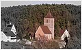
- Catholic parish church St. Vitus : Chorturmkirche, tower marked 1512, hall construction 1622, reconstruction and extension of the nave in neo-Gothic forms 1880; with equipment; Graveyard; Cemetery fortifications, medieval core, with gravestones.
- Rectory , two-storey, massive saddle roof building, around 1700; Outbuilding, barn, single-storey saddle roof construction, natural stone masonry, with half-timbered gable, probably around 1800.
- Settlement from prehistoric times in the aerial photograph, approx. 500 m north of the St. Vitus Church.
See also: → List of architectural monuments in Windsbach # Veitsaurach
mayor
- 1818–1821 Anton Arnold
- 1821–1827 Adam Disterer
- 1827–1828 Franz Anton Wurn
- 1828–1833 Joseph Disterer
- 1833–1836 Johann Kaspar Disterer
- 1836–1854 Kaspar Wieler
- 1854–1882 Georg Disterer
- 1882–1890 Georg Schmidt
- 1890–1906 Joseph Endres
- 1906–1930 Johann Schmidt
- 1930–1945 Johann Domeier
- 1945–1946 Johann Arnold (appointed by the American military government)
- 1946–1960 Josef Dörr
- 1960–1964 Hans Hoffmann (teacher)
- 1964–1978 Johann Georg Disterer
Population development
Veitsaurach community
| year | 1818 | 1840 | 1852 | 1855 | 1861 | 1867 | 1871 | 1875 | 1880 | 1885 | 1890 | 1895 | 1900 | 1905 | 1910 | 1919 | 1925 | 1933 | 1939 | 1946 | 1950 | 1952 | 1961 | 1970 |
|---|---|---|---|---|---|---|---|---|---|---|---|---|---|---|---|---|---|---|---|---|---|---|---|---|
| Residents | 227 | 287 | 314 | 317 | 336 | 349 | 372 | 360 | 369 | 354 | 340 | 370 | 368 | 379 | 358 | 352 | 351 | 333 | 321 | 481 | 396 | 401 | 382 | 382 |
| Houses | 47 | 51 | 64 | 66 | 64 | 64 | 69 | 73 | ||||||||||||||||
| source |
Location Veitsaurach
| year | 1800 | 1818 | 1840 | 1861 | 1871 | 1885 | 1900 | 1925 | 1950 | 1961 | 1970 | 1987 |
|---|---|---|---|---|---|---|---|---|---|---|---|---|
| Residents | 138 | 151 | 192 | 212 | 236 | 213 | 239 | 241 | 277 | 274 | 279 | 270 |
| Houses | 33 | 35 | 44 | 43 | 45 | 48 | 53 | 72 | ||||
| source |
religion
The place has remained predominantly Catholic even after the Reformation. The residents of the Evangelical Lutheran denomination are parish to St. Georg (Bertholdsdorf) , the residents of the Roman Catholic denomination to St. Vitus (Veitsaurach) .
economy


- Construction and furniture joinery
- Construction company
- Development
- Windows, doors and components
- Mold making
- Healing practice
- Metal construction, CNC machining
- Plastic injection molding
- Sparkasse branch until the end of March 2019
- Insurance office
Education and culture
Public facilities
There is a municipal day care center. The Catholic public library was closed in late 2014
leisure
Many cycling and hiking trails lead through Veitsaurach or are nearby: the monastery, church and potato cycle path, hop hiking path, mills on the Aurach, Parzifal path. In the neighboring municipality of Kammerstein there is the legendary hiking trail in the Heidenberg state forest .
societies

- Veitsaurach Volunteer Fire Brigade (founded December 3, 1895)
- DJK Veitsaurach (founded 1958) (football, soccer youth, gymnastics, volleyball)
- Snuff Club
- Veitsaurach theater group
- Kerwaboum Veitsaurach (newly founded in 1994)
- Catholic women's association
Regular events
- Parish festival ( Ascension Day )
- Veits-Kirchweih in Gasthaus Arnold (weekend around June 15; festival for the whole family)
- Midsummer bonfire at the DJK sports grounds (Friday after Midsummer Day )
- Parish fair shooting (beginning of October)
- All-world kerwa at Gasthaus Arnold (third Sunday in October)
- Peasant theater performances by the Veitsaurach theater group (mid-November)
- The Veitsaurach Advent window takes place every 2 years in December . While being together comfortably, the decorated Advent windows of the respective hosts are admired on 23 evenings. On December 24th, the Advent window is always "opened" in the church.
Sons and daughters of the place
- Franz Jakob (born November 17, 1891 in Veitsaurach, † September 10, 1965 in Ingolstadt), German politician.
photos

Veitsaurach with St. Vitus Church

Entering the town, coming from Lanzendorf

Veitsaurach towards Rudelsdorf

"New" school building (around 1910)
View from Bertholdsdorf
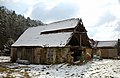
Old barn


literature
- Johann Kaspar Bundschuh : Veitsaurach . In: Geographical Statistical-Topographical Lexicon of Franconia . tape 6 : V-Z . Verlag der Stettinische Buchhandlung, Ulm 1804, DNB 790364328 , OCLC 833753116 , Sp. 5–6 ( digitized version ).
- Karl Dunz : Windsbach - home and cultural history of the city with all districts . Neuendettelsau 1985, p. 285-291 .
- Elisabeth Fechter: The place names of the district of Ansbach . Inaugural dissertation. Erlangen 1955, DNB 480570132 , p. 188 .
- Günther P. Fehring : City and district of Ansbach (= Bavarian art monuments . Volume 2 ). Deutscher Kunstverlag, Munich 1958, DNB 451224701 , p. 144-145 .
- Ludwig Hefele: History of the parish Veitsaurach . Funk Druck, Eichstätt 1977.
- Manfred Jehle: Ansbach: the margravial chief offices Ansbach, Colmberg-Leutershausen, Windsbach, the Nuremberg nursing office Lichtenau and the Deutschordensamt (Wolframs-) Eschenbach (= historical atlas of Bavaria, part Franconia . I, 35). tape 2 . Commission for Bavarian State History, Munich 2009, ISBN 978-3-7696-6856-8 , p. 920, 1012 .
- Konrad Rosenhauer et al. (Ed.): The district of Ansbach. Past and present . Publishing house for authorities and business Hoeppner, Aßling-Pörsdorf 1964, DNB 450093387 , p. 199 .
Web links
- Private website for Veitsaurach
- Veitsaurach on the website windsbach.de
- Veitsaurach in the location database of the Bavarian State Library Online . Bavarian State Library
- Veitsaurach in the Topographia Franconiae of the University of Würzburg , accessed on September 14, 2019.
- Veitsaurach in the historical directory of the association for computer genealogy
Individual evidence
- ↑ a b Bavarian State Office for Statistics and Data Processing (Ed.): Official local directory for Bavaria, territorial status: May 25, 1987 . Issue 450 of the articles on Bavaria's statistics. Munich November 1991, DNB 94240937X , p. 333 ( digitized version ).
- ↑ a b E. Fechter, p. 188.
- ↑ Veitsaurach in the Bavaria Atlas
- ↑ Friedrich Eigler : Schwabach (= Historical Atlas of Bavaria, Part Franconia . I, 28). Michael Laßleben, Kallmünz 1990, ISBN 3-7696-9941-6 , p. 129 .
- ↑ K. Dunz, p. 286.
- ↑ F. Eigler, p. 113f.
- ↑ State Archives Nuremberg , 16-Punkt -berichte 43/1, 9. Quoted from M. Jehle, Vol. 2, p. 733.
- ↑ K. Dunz, pp. 286f.
- ↑ F. Eigler, p. 142.
- ↑ M. Jehle, Vol. 2, p. 748.
- ↑ M. Jehle, Vol. 2, p. 920.
- ^ Johann Bernhard Fischer : Veitsaurach . In: Statistical and topographical description of the Burggraftum Nürnberg, below the mountain, or the Principality of Brandenburg-Anspach. Second part. Containing the economic, statistical and moral condition of these countries according to the fifteen upper offices . Benedict Friedrich Haueisen, Ansbach 1790, p. 409 ( digitized version ).
- ↑ State Archives Nuremberg , Government of Middle Franconia, Chamber of the Interior, Levy 1952, 3850: Formation of the municipal and rural communities in the district court Heilsbronn 1810. Quoted from M. Jehle, vol. 2, p. 963.
- ^ Address and statistical manual for the Rezatkreis in the Kingdom of Baiern . Buchdruckerei Chancellery, Ansbach 1820, p. 44 ( digitized version ).
- ↑ M. Jehle, Vol. 2, p. 1012.
- ↑ a b c Bavarian State Statistical Office (ed.): Official city directory for Bavaria, territorial status on October 1, 1964 with statistical information from the 1961 census . Issue 260 of the articles on Bavaria's statistics. Munich 1964, DNB 453660959 , Section II, Sp. 758 ( digitized version ).
- ^ Federal Statistical Office (ed.): Historical municipality directory for the Federal Republic of Germany. Name, border and key number changes in municipalities, counties and administrative districts from May 27, 1970 to December 31, 1982 . W. Kohlhammer, Stuttgart / Mainz 1983, ISBN 3-17-003263-1 , p. 707 .
- ↑ JK Bundschuh, Vol. 6, Col. 5f.
- ↑ Bavarian State Office for Monument Preservation ( Memento of the original from August 17, 2011 in the Internet Archive ) Info: The archive link has been inserted automatically and has not yet been checked. Please check the original and archive link according to the instructions and then remove this notice.
- ↑ a b Only inhabited houses are given. In 1818 these were designated as fireplaces , in 1840 as houses , and from 1871 to 1987 as residential buildings.
- ↑ a b Alphabetical index of all the localities contained in the Rezatkreise according to its constitution by the newest organization: with indication of a. the tax districts, b. Judicial Districts, c. Rent offices in which they are located, then several other statistical notes . Ansbach 1818, p. 97 ( digitized version ). For the municipality of Veitsaurach plus the residents and buildings of Lanzendorf (p. 52).
- ^ A b Eduard Vetter (Ed.): Statistical handbook and address book of Middle Franconia in the Kingdom of Bavaria . Self-published, Ansbach 1846, p. 152-153 ( digitized version ). The population of Lanzendorf is missing there. Since the statistical handbook and address book of Middle Franconia in the Kingdom of Bavaria (1856) , p. 186, has simply taken over the data from 1846 for this municipality, the population of Lanzendorf added there can be taken over for 1846.
- ↑ a b Bavarian State Statistical Office (Hrsg.): Historical municipality register: The population of the municipalities of Bavaria from 1840 to 1952 (= contributions to the statistics of Bavaria . Issue 192). Munich 1954, DNB 451478568 , p. 174 , urn : nbn: de: bvb: 12-bsb00066439-3 ( digitized version ).
- ↑ a b Joseph Heyberger, Chr. Schmitt, v. Wachter: Topographical-statistical manual of the Kingdom of Bavaria with an alphabetical local dictionary . In: K. Bayer. Statistical Bureau (Ed.): Bavaria. Regional and folklore of the Kingdom of Bavaria . tape 5 . Literary and artistic establishment of the JG Cotta'schen Buchhandlung, Munich 1867, Sp. 1044 , urn : nbn: de: bvb: 12-bsb10374496-4 ( digitized version ).
- ↑ Kgl. Statistisches Bureau (Ed.): Directory of the municipalities of the Kingdom of Bavaria according to the status of the population in December 1867 . XXI. Issue of the contributions to the statistics of the Kingdom of Bavaria. Ackermann, Munich 1869, p. 165 ( digitized version ).
- ↑ a b Kgl. Statistical Bureau (ed.): Complete list of localities of the Kingdom of Bavaria. According to districts, administrative districts, court districts and municipalities, including parish, school and post office affiliation ... with an alphabetical general register containing the population according to the results of the census of December 1, 1875 . Adolf Ackermann, Munich 1877, 2nd section (population figures from 1871, cattle figures from 1873), Sp. 1210 , urn : nbn: de: bvb: 12-bsb00052489-4 ( digitized ).
- ↑ K. Bayer. Statistical Bureau (ed.): Community directory for the Kingdom of Bavaria. Manufactured due to the new organization of government districts, district offices and judicial districts. Addendum to issue 36 of the articles on Bavaria's statistics. Munich 1879, p. 61 ( digitized version ).
- ↑ K. Bayer. Statistical Bureau (ed.): Community directory for the Kingdom of Bavaria. Results of the census of December 1, 1880. Issue 35 of the articles on Bavaria's statistics. Munich 1882, p. 174 ( digitized version ).
- ↑ a b K. Bayer. Statistical Bureau (Ed.): Localities directory of the Kingdom of Bavaria. According to government districts, administrative districts, ... then with an alphabetical register of locations, including the property and the responsible administrative district for each location. LIV. Issue of the contributions to the statistics of the Kingdom of Bavaria. Munich 1888, Section III, Sp. 1096 ( digitized version ).
- ^ A b c d e f g h i Bavarian State Statistical Office (Hrsg.): Historical municipality directory: The population of the municipalities of Bavaria from 1840 to 1952 (= contributions to Statistics Bavaria . Issue 192). Munich 1954, DNB 451478568 , p. 165 , urn : nbn: de: bvb: 12-bsb00066439-3 ( digitized version ).
- ↑ a b K. Bayer. Statistical Bureau (Ed.): Directory of localities of the Kingdom of Bavaria, with alphabetical register of places . LXV. Issue of the contributions to the statistics of the Kingdom of Bavaria. Munich 1904, Section II, Sp. 1160 ( digitized version ).
- ↑ a b Bavarian State Statistical Office (ed.): Localities directory for the Free State of Bavaria according to the census of June 16, 1925 and the territorial status of January 1, 1928 . Issue 109 of the articles on Bavaria's statistics. Munich 1928, Section II, Sp. 1198 ( digitized version ).
- ↑ a b Bavarian State Statistical Office (ed.): Official place directory for Bavaria - edited on the basis of the census of September 13, 1950 . Issue 169 of the articles on Bavaria's statistics. Munich 1952, DNB 453660975 , Section II, Sp. 1031 ( digitized version ).
- ↑ a b Bavarian State Statistical Office (Hrsg.): Official local directory for Bavaria . Issue 335 of the articles on Bavaria's statistics. Munich 1973, DNB 740801384 , p. 171 ( digitized version ).
- ↑ L. Hefele, p. 146f.
- ↑ Romantisches-Franken.de (Tourismusverband Franken e.V.)
- ↑ Fränkischer-Albverein.de
- ↑ on the website Kammerstein , Sagenwanderweg

Bertholdsdorf | Brunn | Buckenmühle | Elpersdorf | Hergersbach | Hölzleinsmühle | Hop mill | Ismannsdorf | Kettersbach | Kitsch Village | Ball mill | Lanzendorf | Leipersloh | Moosbach | Neuses near Windsbach | Retzendorf | Sauernheim | Swallow Mill | Speckheim | Suddersdorf | Thonhof | Untereschenbach | Veitsaurach | Forest house | Wernsmühle | Windsbach (with Fallhaus and Fohlenhof ) | Winkelhaid | Winterhof | Wolf sow