
Lanzendorf (Windsbach)
|
Lanzendorf
City of Windsbach
Coordinates: 49 ° 18 ′ 1 ″ N , 10 ° 53 ′ 5 ″ E
|
|
|---|---|
| Height : | 387 m above sea level NHN |
| Residents : | 95 (May 25 1987) |
| Postal code : | 91575 |
| Area code : | 09871 |
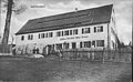
 Town view seen from Winterhof
|
|


Lanzendorf (colloquially: Lantsndorf ) is a district of the town of Windsbach in the district of Ansbach in Middle Franconia .
geography
The village is located on the Lanzenbach, a left tributary of the Aurach . To the northeast is the Dechengraben , 1 km to the northeast the Dechenwald begins . A community road leads to Kitschendorf (1 km northwest) or Veitsaurach to the district road AN 17 (1.1 km south), another community road leads to Winterhof (0.4 km south-west).
history
The place was probably founded before 800, when the East Franconians began to settle the Aurach Valley. In the middle of the 11th century, the Counts of Abenberg were landlords. On March 7, 1296, the place was first mentioned as "Lanzendorf" in a document in which the sale of Abenberg Castle and its affiliations to the Eichstätt Monastery was confirmed. The defining word of the place name is the personal name Lanzo, a short form of Lanfried or Landbold. In the Salbuch in Eichstätt , which was created around 1300, 4 hubs are recorded for the place . 2 of these hubs are smashed in 1405. For the collegiate monastery of St. Nikolaus zu Spalt , the Salbuches of 1380, 1517 and 1549 each specify a subject family in Lanzendorf that is subject to tax.
In the 16-point report of the Oberamt Windsbach from 1608, 6 teams were recorded for Lanzendorf: the 3 farms and 3 goods belonged to the Abenberg caste office in Eichstätt . There was also a communal shepherd's house. The high court exercised the Brandenburg-Ansbach caste and city bailiff's office in Windsbach .
The place was burned down during the 30 Years War . Six subject families perished. In 1653 the place was still considered deserted. In the Eichstätter Salbuch of 1671, 6 subject families are again recorded for Lanzendorf.
Towards the end of the 18th century there were 9 properties in Lanzendorf (2 courtyards, 2 half-courtyards, 3 estates, 2 half-houses) and a community shepherd's house. The high court exercised the Brandenburg-Ansbach caste and city bailiff's office in Windsbach. The Abenberg caste office in Eichstätt held rulership of the village and community and the landlord over all properties. From 1797 to 1808 the place was under the Justice and Chamber Office Windsbach . At that time there were 8 subject families.
As part of the community edict, Lanzendorf was assigned to the Bertholdsdorf tax district formed in 1808 . It also belonged to the rural community of Bertholdsdorf, founded in 1810 . With the second community edict (1818) Lanzendorf was re-grouped into the newly formed rural community Veitsaurach .
On March 28, 1893, Lanzendorf received permission to build a local chapel. It was not built, instead a 3.70 meter high stone cross was erected in 1912, which was consecrated on May 6, 1912.
In 1967 an independent volunteer fire brigade was founded due to the development of the village .
On May 1, 1978, Lanzendorf was incorporated into the municipality of Stadt as part of the regional reform .
Historical images

Map from 1820
Gasthaus Brückner around 1910


Architectural and ground monuments
- About one kilometer northeast of Lanzendorf (In der Reute) there is a memorial stone, the so-called deer trough, which is actually a setting for a stone cross.
- A settlement of prehistoric times in the direction of Veitsaurach on the right on the hill was recognized in the aerial photo.
See also: → List of architectural monuments in Windsbach # Lanzendorf
Population development
| year | 1818 | 1840 | 1861 | 1871 | 1885 | 1900 | 1925 | 1950 | 1961 | 1970 | 1987 |
|---|---|---|---|---|---|---|---|---|---|---|---|
| Residents | 76 | 86 | 114 | 126 | 129 | 119 | 97 | 107 | 100 | 94 | 95 |
| Houses | 14th | 14th | 20th | 19th | 17th | 19th | 18th | 25th | |||
| source |
religion
The residents of the Evangelical Lutheran denomination are parish to St. Georg (Bertholdsdorf) , the residents of the Roman Catholic denomination to St. Vitus (Veitsaurach) .
Trivia
When the Veitsaurach and Lanzendorf schoolchildren got into an argument, the Lanzendorfer were insulted as pussers . Somehow the memory was awake that there were descendants of immigrants from the Pussta in Lanzendorf . Johann Bachmann from Neukirchen married the widow Seger in 1800 "in Pustis, commonly known as Brand". The people of Lanzendorf were also insulted with “their Polack”. This is probably due to the fact that the Alexander from Turufka in Poland came to the parish of Veitsaurach.
photos

Coming from Veitsaurach

coming from Winterhof

Stone cross from 1912

Fire station

Town center

Shepherd's Well


literature
- Johann Kaspar Bundschuh : Lanzendorf . In: Geographical Statistical-Topographical Lexicon of Franconia . tape 3 : I-Ne . Verlag der Stettinische Buchhandlung, Ulm 1801, DNB 790364301 , OCLC 833753092 , Sp. 278 ( digitized version ).
- Karl Dunz : Windsbach - home and cultural history of the city with all districts . Neuendettelsau 1985, p. 291-293 .
- Elisabeth Fechter: The place names of the district of Ansbach . Inaugural dissertation. Erlangen 1955, DNB 480570132 , p. 121 .
- Günther P. Fehring : City and district of Ansbach (= Bavarian art monuments . Volume 2 ). Deutscher Kunstverlag, Munich 1958, DNB 451224701 , p. 118 .
- Ludwig Hefele: History of the parish Veitsaurach . Funk Druck, Eichstätt 1977, p. 149-154, 295-331 .
- Manfred Jehle: Ansbach: the margravial chief offices Ansbach, Colmberg-Leutershausen, Windsbach, the Nuremberg nursing office Lichtenau and the Deutschordensamt (Wolframs-) Eschenbach (= historical atlas of Bavaria, part Franconia . I, 35). tape 2 . Commission for Bavarian State History, Munich 2009, ISBN 978-3-7696-6856-8 , p. 879 .
Web links
- Lanzendorf on the website windsbach.de
- Lanzendorf in the location database of the Bayerische Landesbibliothek Online . Bavarian State Library
- Lanzendorf in the Topographia Franconiae of the University of Würzburg , accessed on September 14, 2019.
- Lanzendorf in the historical directory of the association for computer genealogy
Individual evidence
- ↑ a b Bavarian State Office for Statistics and Data Processing (Ed.): Official local directory for Bavaria, territorial status: May 25, 1987 . Issue 450 of the articles on Bavaria's statistics. Munich November 1991, DNB 94240937X , p. 333 ( digitized version ).
- ↑ a b E. Fechter, p. 121.
- ↑ Lanzendorf in the Bavaria Atlas
- ↑ K. Dunz, p. 291.
- ↑ Friedrich Eigler : Schwabach (= Historical Atlas of Bavaria, Part Franconia . I, 28). Michael Laßleben, Kallmünz 1990, ISBN 3-7696-9941-6 , p. 129 .
- ↑ F. Eigler, p. 113.
-
^ Staatsarchiv Nürnberg , 16-Punkt -berichte 43/1, 8. Quoted from M. Jehle, Vol. 2, S. 731.
1 Gut was not subordinate to the Abenberg caste office. It is listed in the Salbuch of the Spalter Kollegiatstiftes from 1619 for Lanzendorf. F. Eigler, p. 114. - ↑ K. Dunz, p. 292.
- ↑ F. Eigler, p. 142.
- ↑ M. Jehle, Vol. 2, p. 879.
- ^ Johann Bernhard Fischer : Lanzendorf . In: Statistical and topographical description of the Burggraftum Nürnberg, below the mountain, or the Principality of Brandenburg-Anspach. Second part. Containing the economic, statistical and moral condition of these countries according to the fifteen upper offices . Benedict Friedrich Haueisen, Ansbach 1790, p. 307 ( digitized version ). Here the place is assigned to the Oberamt Schwabach . 1 property was in the Fraisch district of Windsbach .
- ↑ JK Bundschuh, Vol. 3, Col. 278.
- ↑ State Archives Nuremberg , Government of Middle Franconia, Chamber of the Interior, Levy 1952, 3850: Formation of the municipal and rural communities in the district court Heilsbronn 1810. Quoted from M. Jehle, vol. 2, p. 963.
- ↑ K. Dunz, p. 293.
- ^ GP Fehring, p. 118.
- ↑ Only inhabited houses are given. In 1818 these were designated as fireplaces , in 1840 as houses , and from 1871 to 1987 as residential buildings.
- ↑ Alphabetical index of all the localities contained in the Rezatkkreis according to its constitution by the newest organization: with indication of a. the tax districts, b. Judicial Districts, c. Rent offices in which they are located, then several other statistical notes . Ansbach 1818, p. 52 ( digitized version ).
- ↑ Eduard Vetter (Ed.): Statistical handbook and address book of Middle Franconia in the Kingdom of Bavaria . Self-published, Ansbach 1846, p. 152-153 ( digitized version ). The population of Lanzendorf is missing there. Since the statistical handbook and address book of Middle Franconia in the Kingdom of Bavaria (1856) , p. 186, has simply taken over the data from 1846 for this municipality, the population of Lanzendorf added there can be taken over for 1840.
- ^ Joseph Heyberger, Chr. Schmitt, v. Wachter: Topographical-statistical manual of the Kingdom of Bavaria with an alphabetical local dictionary . In: K. Bayer. Statistical Bureau (Ed.): Bavaria. Regional and folklore of the Kingdom of Bavaria . tape 5 . Literary and artistic establishment of the JG Cotta'schen Buchhandlung, Munich 1867, Sp. 1044 , urn : nbn: de: bvb: 12-bsb10374496-4 ( digitized version ).
- ↑ Kgl. Statistical Bureau (ed.): Complete list of localities of the Kingdom of Bavaria. According to districts, administrative districts, court districts and municipalities, including parish, school and post office affiliation ... with an alphabetical general register containing the population according to the results of the census of December 1, 1875 . Adolf Ackermann, Munich 1877, 2nd section (population figures from 1871, cattle figures from 1873), Sp. 1210 , urn : nbn: de: bvb: 12-bsb00052489-4 ( digitized ).
- ↑ K. Bayer. Statistical Bureau (Ed.): Localities directory of the Kingdom of Bavaria. According to government districts, administrative districts, ... then with an alphabetical register of locations, including the property and the responsible administrative district for each location. LIV. Issue of the contributions to the statistics of the Kingdom of Bavaria. Munich 1888, Section III, Sp. 1096 ( digitized version ).
- ↑ K. Bayer. Statistical Bureau (Ed.): Directory of localities of the Kingdom of Bavaria, with alphabetical register of places . LXV. Issue of the contributions to the statistics of the Kingdom of Bavaria. Munich 1904, Section II, Sp. 1160 ( digitized version ).
- ↑ Bavarian State Statistical Office (ed.): Localities directory for the Free State of Bavaria according to the census of June 16, 1925 and the territorial status of January 1, 1928 . Issue 109 of the articles on Bavaria's statistics. Munich 1928, Section II, Sp. 1198 ( digitized version ).
- ↑ Bavarian State Statistical Office (ed.): Official place directory for Bavaria - edited on the basis of the census of September 13, 1950 . Issue 169 of the articles on Bavaria's statistics. Munich 1952, DNB 453660975 , Section II, Sp. 1031 ( digitized version ).
- ↑ Bavarian State Statistical Office (ed.): Official city directory for Bavaria, territorial status on October 1, 1964 with statistical information from the 1961 census . Issue 260 of the articles on Bavaria's statistics. Munich 1964, DNB 453660959 , Section II, Sp. 758 ( digitized version ).
- ^ Bavarian State Statistical Office (ed.): Official place directory for Bavaria . Issue 335 of the articles on Bavaria's statistics. Munich 1973, DNB 740801384 , p. 171 ( digitized version ).
- ↑ L. Hefele, p. 153.

Bertholdsdorf | Brunn | Buckenmühle | Elpersdorf | Hergersbach | Hölzleinsmühle | Hop mill | Ismannsdorf | Kettersbach | Kitsch Village | Ball mill | Lanzendorf | Leipersloh | Moosbach | Neuses near Windsbach | Retzendorf | Sauernheim | Swallow Mill | Speckheim | Suddersdorf | Thonhof | Untereschenbach | Veitsaurach | Forest house | Wernsmühle | Windsbach (with Fallhaus and Fohlenhof ) | Winkelhaid | Winterhof | Wolf sow