
Insingen
| coat of arms | Germany map | |
|---|---|---|

|
Coordinates: 49 ° 18 ' N , 10 ° 10' E |
|
| Basic data | ||
| State : | Bavaria | |
| Administrative region : | Middle Franconia | |
| County : | Ansbach | |
| Management Community : | Rothenburg ob der Tauber | |
| Height : | 399 m above sea level NHN | |
| Area : | 21.32 km 2 | |
| Residents: | 1166 (Dec. 31, 2019) | |
| Population density : | 55 inhabitants per km 2 | |
| Postal code : | 91610 | |
| Area code : | 09869 | |
| License plate : | AN , DKB, FEU, ROT | |
| Community key : | 09 5 71 169 | |
| Community structure: | 9 parts of the community | |
| Address of the municipal administration: |
Hausener Str. 7 91610 Insingen |
|
| Website : | ||
| Mayor : | Peter Köhnlechner ( community of voters ) | |
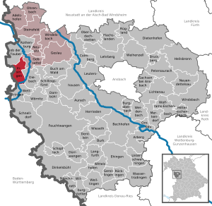
| Location of the municipality of Insingen in the district of Ansbach | ||
  |
||

Insingen is a municipality in the district of Ansbach in Middle Franconia . The place of the same name is both the capital and the seat of the municipal administration.
geography
location
The community is located in the Frankenhöhe Nature Park .
Community structure
The municipality has nine officially named municipal parts (the type of settlement is indicated in brackets ):
|
The wasteland Fallhaus is not an officially named part of the community.
Neighboring communities
Neighboring municipalities are (starting in the north in a clockwise direction):
- Gebsattel
- The stream
- Competition
- Rot am See (Baden-Württemberg)
- Rothenburg ob der Tauber

history
Place name
The place was first mentioned in 1079 as "Ingesingen". The place name is based on the personal name Ingis, which was derived from the affiliation suffix -ingen . The place name means With the people of the Ingis .
Early modern age
A line of the Lords of Rothenburg was called "von Insingen" in the 13th century. The blue / silver part of today's municipal coat of arms comes from this gender. Insingen belonged to the Reichsstift Rothenburg and from 1500 to the Franconian Empire ; Parts of the bailiwick were in the Prussian principality of Ansbach .
As a specialty, Insingen is one of the few Franconian places for which an early modern village order has been preserved. It was announced to the residents on April 27, 1620 in the “Rothenburgische Wirtshaus” in Insingen. At that time Insingen counted 56 farmers and Köblers who were considered "common rights", that is, residents with rights and duties defined by the village regulations.
19th century
Since the Reichsdeputationshauptschluss of 1803, the place - like large parts of Franconia - belongs to Bavaria (see also history of Franconia ).
With the community edict (early 19th century) the tax district and the rural community Insingen were formed, to which the towns Fallhaus , Hammerschmiede , Kappenmühle, Kastenmühle and Wilhelmsmühle belonged. It was subordinate to the regional court of Rothenburg in administration and jurisdiction . and in the financial administration the Rentamt Rothenburg . In 1961 the municipality had an area of 14.024 km².
Incorporations
On May 1, 1978, the previously independent community of Lohr was incorporated.
Population development
In the period from 1988 to 2018, the population increased from 930 to 1169 by 239 inhabitants or by 25.7%.
Insingen parish
| year | 1818 | 1840 | 1852 | 1861 | 1867 | 1871 | 1875 | 1880 | 1885 | 1890 | 1895 | 1900 | 1905 | 1910 | 1919 | 1925 | 1933 | 1939 | 1946 | 1950 | 1961 | 1970 | 1987 | 2005 | 2011 | 2015 |
|---|---|---|---|---|---|---|---|---|---|---|---|---|---|---|---|---|---|---|---|---|---|---|---|---|---|---|
| Residents | 627 | 603 | 634 | 611 | 596 | 595 | 604 | 631 | 627 | 647 | 628 | 636 | 605 | 609 | 614 | 613 | 604 | 548 | 723 | 725 | 645 | 638 | 934 | 1142 | 1127 | 1184 |
| Houses | 120 | 102 | 106 | 113 | 121 | 118 | 127 | 128 | 245 | 322 | 326 | |||||||||||||||
| source |
Part of the municipality Insingen
| year | 1818 | 1840 | 1861 | 1871 | 1885 | 1900 | 1925 | 1950 | 1961 | 1970 | 1987 |
|---|---|---|---|---|---|---|---|---|---|---|---|
| Residents | 497 | 462 | 487 | 471 | 495 | 508 * | 485 * | 592 * | 549 * | 558 | 588 |
| Houses | 99 | 84 | 94 | 99 * | 98 * | 106 * | 110 * | 168 | |||
| source |
politics
The community is a member of the Rothenburg ob der Tauber administrative community .
Municipal council
After the last local election on March 16, 2014 , the local council has twelve members. The turnout was 60.89%. The choice brought the following result:
| Voting Community Insingen | 8 seats | (69.3%) | |
| Voting community Insingen-Nord | 4 seats | (30.7%) |
Another member and chairman of the municipal council is the First Mayor Peter Köhnlechner.
badges and flags
Insingen has had its own coat of arms since 1986.
|
|
Blazon : " Divided diagonally to the right, below three times divided by silver and blue, above in gold a red cancer lying diagonally to the right."
White-red-white municipal flag. |
| Founding of the coat of arms: The municipality of Insingen has consisted of the formerly independent municipalities of Insingen and Lohr since 1978. The cancer comes from the coat of arms of the Knights of Lohr, which can be traced back to the 13th century. The other half ("divided three times by silver and blue") comes from the coat of arms of the Lords of Insingen, which was first mentioned in 1308. |
Architectural monuments
Economy and Infrastructure
The community is a member of the Romantic Franconian Tourist Association .
traffic
The national road 2223 runs east of Insingen and leads to Lohr or to Untergailnau past the junction 109 of the Bundesautobahn 7 at Wörnitz . The state road 2247 leading to Diebach . The district road AN 7 / K 2514 leads to Hausen am Bach . Community roads lead to book for the L 1040 and to forge .
There are various bus connections that are covered by several bus stops in the municipality. This means that Insingen is connected to the rail network (e.g. Rothenburg ob der Tauber station, Dohmbühl S-Bahn station ).
media
Insingen has been the headquarters of Degener Verlag , the most important genealogical publisher in Germany , since 2006 . At the Leuzhof there is a VHF transmitter for broadcasting the "Radio 8" program on 104.7 MHz with 50 W ERP.
literature
- Johann Kaspar Bundschuh : Insingen . In: Geographical Statistical-Topographical Lexicon of Franconia . tape 3 : I-Ne . Verlag der Stettinische Buchhandlung, Ulm 1801, DNB 790364301 , OCLC 833753092 , Sp. 21-23 ( digitized version ).
- Eduard Otto: A Franconian village at the beginning of the 17th century. In: Journal for Social and Economic History, Vol. 7 (1899), pp. 331–355.
- Hans Karlmann Ramisch: District of Rothenburg ob der Tauber (= Bavarian art monuments . Volume 25 ). Deutscher Kunstverlag, Munich 1967, DNB 457879254 , p. 51-55 .
- Wolf-Armin von Reitzenstein : Lexicon of Franconian place names. Origin and meaning . Upper Franconia, Middle Franconia, Lower Franconia. CH Beck, Munich 2009, ISBN 978-3-406-59131-0 , p. 110 .
- Gottfried Stieber: Insingen . In: Historical and topographical news from the Principality of Brandenburg-Onolzbach . Johann Jacob Enderes, Schwabach 1761, p. 515-517 ( digitized version ).
See also
Web links
- Local government
- Insingen in the Topographia Franconiae of the University of Würzburg , accessed on September 18, 2019.
- Insingen: Official statistics of the LfStat
Individual evidence
- ↑ "Data 2" sheet, Statistical Report A1200C 202041 Population of the municipalities, districts and administrative districts 1st quarter 2020 (population based on the 2011 census) ( help ).
- ^ Community of Insingen in the local database of the Bavarian State Library Online . Bayerische Staatsbibliothek, accessed on September 18, 2019.
- ↑ W.-A. v. Reitzenstein, p. 110.
- ^ Eduard Otto: A Franconian village at the beginning of the 17th century. In: Zeitschrift für Social- und Wirthschaftsgeschichte , vol. 7 (1899), pp. 331–355, here p. 332.
- ^ Eduard Otto: A Franconian village at the beginning of the 17th century. In: Journal for Social and Economic History, Jg. 7 (1899), pp. 331–355, here p. 333.
- ↑ Johannes Neumann: The Reichsdeputationshauptschluss of 1803: Requirements and consequences (PDF file; 179 kB)
- ^ Address and statistical manual for the Rezatkreis in the Kingdom of Baiern . Buchdruckerei Chancellery, Ansbach 1820, p. 66 ( digitized version ).
- ↑ a b c Bavarian State Statistical Office (ed.): Official city directory for Bavaria, territorial status on October 1, 1964 with statistical information from the 1961 census . Issue 260 of the articles on Bavaria's statistics. Munich 1964, DNB 453660959 , Section II, Sp. 815 ( digitized version ).
- ^ Federal Statistical Office (ed.): Historical municipality directory for the Federal Republic of Germany. Name, border and key number changes in municipalities, counties and administrative districts from May 27, 1970 to December 31, 1982 . W. Kohlhammer, Stuttgart / Mainz 1983, ISBN 3-17-003263-1 , p. 706 .
- ↑ a b Only inhabited houses are given. In 1818 these were designated as fireplaces , in 1840 as houses , and from 1871 to 2015 as residential buildings.
- ↑ a b Alphabetical index of all the localities contained in the Rezatkreise according to its constitution by the newest organization: with indication of a. the tax districts, b. Judicial Districts, c. Rent offices in which they are located, then several other statistical notes . Ansbach 1818, p. 45 ( digitized version ). For the municipality of Insingen plus the residents and buildings of Fallhaus (p. 24), Hammerschmiede (p. 36), Kappenmühle (p. 46), Kastenmühle (p. 46), Leidenberg (p. 53), Lohrbach (p. 56 ), Sandhof (p. 80) and Wilhelmsmühle (p. 103).
- ^ A b Eduard Vetter (Ed.): Statistical handbook and address book of Middle Franconia in the Kingdom of Bavaria . Self-published, Ansbach 1846, p. 224 ( digitized version ). According to the historical municipality register, the municipality had 605 inhabitants.
- ^ A b c d e f g h i Bavarian State Statistical Office (Hrsg.): Historical municipality directory: The population of the municipalities of Bavaria from 1840 to 1952 (= contributions to Statistics Bavaria . Issue 192). Munich 1954, DNB 451478568 , p. 182 , urn : nbn: de: bvb: 12-bsb00066439-3 ( digitized version ).
- ↑ a b Joseph Heyberger, Chr. Schmitt, v. Wachter: Topographical-statistical manual of the Kingdom of Bavaria with an alphabetical local dictionary . In: K. Bayer. Statistical Bureau (Ed.): Bavaria. Regional and folklore of the Kingdom of Bavaria . tape 5 . Literary and artistic establishment of the JG Cotta'schen Buchhandlung, Munich 1867, Sp. 1072 , urn : nbn: de: bvb: 12-bsb10374496-4 ( digitized version ).
- ↑ Kgl. Statistisches Bureau (Ed.): Directory of the municipalities of the Kingdom of Bavaria according to the status of the population in December 1867 . XXI. Issue of the contributions to the statistics of the Kingdom of Bavaria. Ackermann, Munich 1869, p. 171 ( digitized version ).
- ↑ a b Kgl. Statistical Bureau (ed.): Complete list of localities of the Kingdom of Bavaria. According to districts, administrative districts, court districts and municipalities, including parish, school and post office affiliation ... with an alphabetical general register containing the population according to the results of the census of December 1, 1875 . Adolf Ackermann, Munich 1877, 2nd section (population figures from 1871, cattle figures from 1873), Sp. 1238 , urn : nbn: de: bvb: 12-bsb00052489-4 ( digital copy ).
- ↑ K. Bayer. Statistical Bureau (ed.): Community directory for the Kingdom of Bavaria. Manufactured due to the new organization of government districts, district offices and judicial districts. Addendum to issue 36 of the articles on Bavaria's statistics. Munich 1879, p. 68 ( digitized version ).
- ↑ K. Bayer. Statistical Bureau (ed.): Community directory for the Kingdom of Bavaria. Results of the census of December 1, 1880. Issue 35 of the articles on Bavaria's statistics. Munich 1882, p. 194 ( digitized version ).
- ↑ a b K. Bayer. Statistical Bureau (Ed.): Localities directory of the Kingdom of Bavaria. According to government districts, administrative districts, ... then with an alphabetical register of locations, including the property and the responsible administrative district for each location. LIV. Issue of the contributions to the statistics of the Kingdom of Bavaria. Munich 1888, Section III, Sp. 1173-1174 ( digitized version ).
- ↑ a b K. Bayer. Statistical Bureau (Ed.): Directory of localities of the Kingdom of Bavaria, with alphabetical register of places . LXV. Issue of the contributions to the statistics of the Kingdom of Bavaria. Munich 1904, Section II, Sp. 1245 ( digitized version ).
- ↑ a b Bavarian State Statistical Office (ed.): Localities directory for the Free State of Bavaria according to the census of June 16, 1925 and the territorial status of January 1, 1928 . Issue 109 of the articles on Bavaria's statistics. Munich 1928, Section II, Sp. 1284 ( digitized version ).
- ↑ a b Bavarian State Statistical Office (ed.): Official place directory for Bavaria - edited on the basis of the census of September 13, 1950 . Issue 169 of the articles on Bavaria's statistics. Munich 1952, DNB 453660975 , Section II, Sp. 1112 ( digitized version ).
- ↑ a b Bavarian State Statistical Office (Hrsg.): Official local directory for Bavaria . Issue 335 of the articles on Bavaria's statistics. Munich 1973, DNB 740801384 , p. 170 ( digitized version ).
- ↑ a b Bavarian State Office for Statistics and Data Processing (Ed.): Official local directory for Bavaria, territorial status: May 25, 1987 . Issue 450 of the articles on Bavaria's statistics. Munich November 1991, DNB 94240937X , p. 328 ( digitized version ).
- ↑ a b c Insingen: Official statistics of the LfStat
- ↑ BayernPortal: Municipality of Insingen. Bavarian State Ministry for Digital, accessed on August 25, 2020 .
- ^ Entry on the coat of arms of Insingen in the database of the House of Bavarian History
- ↑ Insingen. In: Kommunalflaggen.eu. Retrieved February 29, 2020 .

Adelshofen | Arberg | Aurach | Bechhofen | Bruckberg | Book at the forest | Burgoberbach | Burk | Colmberg | Dentlein am Forst | Diebach | Dietenhofen | Dinkelsbühl | Dombühl | Dürrwangen | Ehingen | Feuchtwangen | Flachslanden | Gebsattel | Gerolfingen | Geslau | Heilsbronn | Herrieden | Insingen | Langfurth | Lehrberg | Leutershausen | Lichtenau | Merkendorf | Mitteleschenbach | Mönchsroth | Neuendettelsau | Neusitz | Oberdachstetten | Ohrbach | Ornbau | Petersaurach | Röckingen | Rothenburg ob der Tauber | Rügland | Saxony near Ansbach | Schillingsfürst | Schnelldorf | Schopfloch | Steinsfeld | Unterschwaningen | Wassertrüdingen | Weidenbach | Weihenzell | Weiltingen | Wettringen | Wieseth | Wilburgstetten | Windelsbach | Windsbach | Wittelshofen | Wolframs-Eschenbach | Wörnitz
Unregulated areas:
Lower Forest