Sachsenflur
|
Sachsenflur
City of Lauda-Königshofen
|
|
|---|---|
| Coordinates: 49 ° 31 ′ 33 " N , 9 ° 42 ′ 35" E | |
| Area : | 5.98 km² |
| Residents : | 318 (Jan 1, 2015) |
| Population density : | 53 inhabitants / km² |
| Incorporation : | January 1, 1972 |
| Incorporated into: | Koenigshofen |
| Postal code : | 97922 |
| Area code : | 09343 |
|
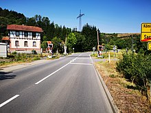
View of Sachsenflur, 2016
|
|
Sachsenflur is one of twelve districts of the city of Lauda-Königshofen in the Main-Tauber district , the northernmost district of Baden-Württemberg .
history
Sachsenflur was first mentioned in a document in 1230.
On January 1, 1972, Sachsenflur came to the city of Königshofen. In the course of the municipality reform in Baden-Württemberg , the city of Lauda-Königshofen was formed from the two cities of Lauda and Königshofen as well as ten other formerly independent municipalities, including Sachsenflur, on January 1, 1975 .
Culture and sights
Cultural monuments
Biking and hiking trails
Sachsenflur is located on the Umpfertal cycle path . Via Königshofen there is a connection to the Taubertal cycle path and in Unterschüpf to the cycle path Liebliches Taubertal - the sporty one . The approximately 180 kilometer long Jakobsweg Main-Taubertal leads up to a hill near Sachsenflur.
traffic
Sachsenflur is on federal highway 292 .
The Sachsenflur stop on the Stuttgart – Würzburg railway line, opened in 1903, no longer exists. Its station building was demolished decades ago.
Personalities
Web links
- Sachsenflur on the leo-bw.de website
Individual evidence
- ^ A b City of Lauda-Knigshofen: structural data . Lauda-Königshofen in numbers . Online at www.lauda-koenigshofen.de. Retrieved January 13, 2018.
- ↑ LEO-BW.de: Sachsenflur on the leo-bw.de website. Retrieved March 13, 2018.
- ^ Federal Statistical Office (ed.): Historical municipality directory for the Federal Republic of Germany. Name, border and key number changes in municipalities, counties and administrative districts from May 27, 1970 to December 31, 1982 . W. Kohlhammer, Stuttgart / Mainz 1983, ISBN 3-17-003263-1 , p. 480 .
- ^ Federal Statistical Office (ed.): Historical municipality directory for the Federal Republic of Germany. Name, border and key number changes in municipalities, counties and administrative districts from May 27, 1970 to December 31, 1982 . W. Kohlhammer, Stuttgart / Mainz 1983, ISBN 3-17-003263-1 , p. 469 f .
- ^ City of Lauda-Königshofen: The history of Lauda-Königshofen . Online at www.lauda-koenigshofen.de. Retrieved March 13, 2018.
- ↑ "The Sportive" - Tourist Association Liebliches Taubertal. In: liebliches-taubertal.de. Retrieved August 3, 2020 .
- ↑ 3rd day stage - Külsheim to Boxberg - Liebliches Taubertal tourist office. In: liebliches-taubertal.de. Retrieved August 3, 2020 .
- ↑ Jakobsweg Main-Taubertal (pilgrimage route) - wanderkompass.de. In: wanderkompass.de. Retrieved August 3, 2020 .
- ^ Uwe Büttner: 150 years of the Frankenbahn . Mainpost of October 28, 2016, accessed July 2, 2018.


