
Kupprichhausen
|
Kupprichhausen
City of Boxberg
|
|
|---|---|
 |
|
| Residents : | 278 (Dec. 31, 2014) |
| Incorporation : | July 1, 1971 |
| Postal code : | 97944 |
| Area code : | 07930 |
 View of Kupprichhausen (2017)
|
|
Kupprichhausen (colloquially also called Cuba ) is a district of Boxberg in the Main-Tauber district and has 278 inhabitants (as of December 31, 2014).
geography
![]() Map with all coordinates of the residential areas in the district of Kupprichhausen: OSM
Map with all coordinates of the residential areas in the district of Kupprichhausen: OSM

Kupprichhausen lies in a basin of the upper Schüpfergrund, which forms a large side valley of the Umpfer . The village is dominated by hills to the east and west. The Schüpfbach , which gives the valley its name, rises north of the village.
The village of Kupprichhausen ( ⊙ ) and the Ahornhof ( ⊙ ) residential area as well as the abandoned villages of Dietenhausen, Goldberg, Meisenheim and Weildorf belong to the former municipality of Kupprichhausen .
history
Kupprichhausen emerged from several former local settlements: Meisenheim (today: Ahornhof ), Dietenhausen , Goldberg and Cup (er) gehusen . On July 1, 1971, Kupprichhausen was incorporated into Boxberg and is one of the 13 suburbs there.
Population development
The population of Kupprichhausen developed as follows:
| year | total |
|---|---|
| 1961 | 376 |
| 1970 | 346 |
| 2014 | 278 |
Culture and sights

Architectural monuments
The All Saints Church, first mentioned in 1440, is located in the center of Kupprichhausen.
Wayside shrines and statues
In Kupprichhausen there are also numerous beautiful wayside shrines.
There are also two statues of the bridge saint Johannes Nepomuk in the village, to the left of the All Saints Church and a sad Nepomuk statue on the Kupprichhäuser Schüpfbach Bridge.
- Wayside shrines and statues in Kupprichhausen
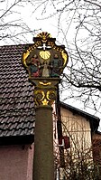
Restored wayside shrine in the center of the village

Wayside shrine at the rectory

Sad Nepomuk statue on the bridge over the Schüpfbach
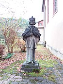
Nepomuk statue at the All Saints Church


Biking and hiking trails
Kupprichhausen is located on the Schüpfbachtal cycle path or the Liebliches Taubertal cycle path - the sporty one .
Regular events
Although the earlier agriculture and forestry has lost much of its importance, the Grünkernfest takes place annually at the Kupprichhausen sports grounds . Even today, the unripe spelled is harvested and dried to make green spelled. There is still a green spelled kiln in Cuba today.
traffic
The Ahorn junction (junction 4) of the A 81 is in the district of Kupprichhausen.
Personalities
Web links
- History of Kupprichhausen on the website of the city of Boxberg.
- Kupprichhausen on the website taubertal.de
Individual evidence
- ↑ a b c City of Boxberg: Kupprichhausen . Online at www.boxberg.de. Retrieved December 2, 2016.
- ↑ a b c d Taubertal.de: Kupprichhausen . Online at www.taubertal.de. Retrieved December 9, 2016.
- ^ The state of Baden-Württemberg. Official description by district and municipality. Volume IV: Stuttgart district, Franconian and East Württemberg regional associations. Kohlhammer, Stuttgart 1980, ISBN 3-17-005708-1 . Pp. 294-302.
- ↑ Ulshöfer: Kupprichhausen . Online at www.boxberg.ulshoefer.com. Retrieved January 13, 2017.
- ↑ a b c City of Boxberg: History of Kupprichhausen . Online at www.boxberg.de. Retrieved January 13, 2017.
- ^ Federal Statistical Office (ed.): Historical municipality directory for the Federal Republic of Germany. Name, border and key number changes in municipalities, counties and administrative districts from May 27, 1970 to December 31, 1982 . W. Kohlhammer, Stuttgart / Mainz 1983, ISBN 3-17-003263-1 , p. 480 .
- ↑ Population, occupation and workplace censuses in West Germany from June 6, 1961 (municipal register).
- ↑ Population, occupation and workplace censuses in West Germany from May 27, 1970 (municipal register).
- ↑ Leo-BW.de: Kupprichhausen . Online at www.leo-bw.de. Retrieved November 18, 2016.
- ↑ "The Sportive" - Tourist Association Liebliches Taubertal. In: liebliches-taubertal.de. Retrieved August 3, 2020 .
- ↑ 3rd day stage - Külsheim to Boxberg - Liebliches Taubertal tourist office. In: liebliches-taubertal.de. Retrieved August 3, 2020 .
- ↑ LUBW: View of junction 4 Ahorn (Permalink) at udo.lubw.baden-wuerttemberg.de
Fishing turn | Bobstadt | Boxberg | Epplingen | Kupprichhausen | Lengenrieden | Oberschüpf | Schwabhausen | Stay silent | Uiffingen | Under | Windischbuch | Wölchingen