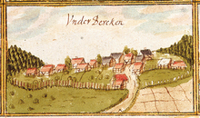
Oberberken
|
Oberberken with Unterberken
Large district town of Schorndorf
|
|
|---|---|
| Coordinates: 48 ° 46 ′ 37 ″ N , 9 ° 33 ′ 9 ″ E | |
| Height : | 466-513 m |
| Area : | 12.57 km² |
| Residents : | 1554 (Jan 31, 2008) |
| Population density : | 124 inhabitants / km² |
| Incorporation : | 1st January 1975 |
| Postal code : | 73614 |
| Area code : | 07181 |
Oberberken is a district of Schorndorf ( Rems-Murr-Kreis , Baden-Württemberg ). The place is about 500 meters above sea level on one of the highest points of the Schurwald on the so-called " rear Schur ". The associated separately located Unterberken residential area is just under 2 km south-east at an altitude of around 466 m. The formerly rural village is located on the historic Kaiserstraße, which connects Hohenstaufen Castle with Waiblingen .
history

Oberberken was first mentioned in a document in 1110, when Conrad von Beutelsbach received 10 hubs in "Berckha" in exchange with the Hirsau Monastery , which Cuno and Uta von Hurningen had once bequeathed to the convent. The castle of the Volknand von Staufen, a Staufer servant who is considered to be the founder of the Adelberg Monastery , once stood south of today's Unterberken residential area in the "Burgholz" state forest .

In addition to the Adelberg monastery and Conrad von Beutelsbach, the Backnang monastery (1245), the lords of Vilsegge (1294), von Husen (1317), von Widstatt and those of Talheim (1408) owned Oberberken. From 1535 - after the dissolution of the convent - almost all of Ober- and Unterberken were part of the (Württemberg) monastery office of Adelberg. Only three fiefdoms in "Obernberckach" were directly under the Württemberg bailiwick and were therefore assigned to the Oberurbach staff. During the implementation of the new administrative structure in the Kingdom of Württemberg , Oberberken was assigned to the Oberamt Schorndorf in 1807 . In 1824 Oberberken was raised to a municipality with Unterberken. Before that, the places belonged to Hundsholz (today Adelberg ). The administrative reform of 1938 led to membership in the Waiblingen district . Due to the district reform in Baden-Württemberg in 1973, Oberberken became part of the Rems-Murr district . The independence ended with the incorporation into the town of Schorndorf as part of the regional reform on January 1st, 1975.
politics
Oberberken together with Unterberken a village within the meaning of Baden-Württemberg municipal code with its own existing ten members Ortschaftsrat .
coat of arms
The Oberberken coat of arms shows a white (silver) shield, on the right edge of which a red abbot's staff begins with a curvature pointing downwards and points to the top left. The colors (red / white) for the coat of arms used since 1909 were already determined in 1952, but the coat of arms was not officially awarded by the Baden-Württemberg Ministry of the Interior until February 9, 1970.
Facilities
In Oberberken there is a primary school, the Schurwaldschule; The core city of Schorndorf offers secondary schools. In addition, in the district there is the Kindergarten am Wasserturm (the Kindergarten In den Geißhecken will be closed in July 2016), a small grocery store, an administrative office, two bakeries, a branch of the Volksbank Stuttgart and the Schurwaldhalle, a multi-purpose hall that has won multiple awards due to its architecture. and several sports fields. The SOS Children's Village in Württemberg, which is located here, has been contributing to national awareness since 1960 .
traffic
Oberberken is on Landstrasse 1225, which connects the Remstal (near Schorndorf) with the Filstal (near Göppingen ). In addition, the bus line 260 (Göppingen – Schorndorf) of the Stuttgart transport and tariff association opens up the district.
Individual evidence
- ^ Federal Statistical Office (ed.): Historical municipality directory for the Federal Republic of Germany. Name, border and key number changes in municipalities, counties and administrative districts from May 27, 1970 to December 31, 1982 . W. Kohlhammer, Stuttgart / Mainz 1983, ISBN 3-17-003263-1 , p. 464 .
- ↑ Main statute of the city of Schorndorf in the new version of July 24, 2000, last amended on May 30, 2018
literature
- Horst Lässing (Hrsg.): Home and work: The Rems-Murr-Kreis . Konrad Theiss, Stuttgart 1980, ISBN 3-8062-0243-5 , p. 300
