
Adelberg
| coat of arms | Germany map | |
|---|---|---|

|
Coordinates: 48 ° 46 ' N , 9 ° 36' E |
|
| Basic data | ||
| State : | Baden-Württemberg | |
| Administrative region : | Stuttgart | |
| County : | Goeppingen | |
| Administrative association: | Eastern virgin forest | |
| Height : | 472 m above sea level NHN | |
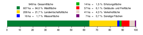
| Area : | 9.49 km 2 | |
| Residents: | 1997 (Dec. 31, 2018) | |
| Population density : | 210 inhabitants per km 2 | |
| Postal code : | 73099 | |
| Area code : | 07166 | |
| License plate : | GP | |
| Community key : | 08 1 17 001 | |
| Address of the municipal administration: |
Vordere Hauptstrasse 2 73099 Adelberg |
|
| Website : | ||
| Mayoress : | Carmen Marquardt | |
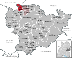
| Location of the municipality of Adelberg in the district of Göppingen | ||
  |
||

Adelberg is a municipality in the district of Göppingen in Baden-Württemberg . It belongs to the Stuttgart region (until 1992 the Middle Neckar region ) and the peripheral zone of the European metropolitan region of Stuttgart . Until 1851 the place was called Hundsholz , after which it took over the name of the nearby Adelberg Monastery .
geography
Geographical location
Adelberg lies on the eastern Schurwald at an altitude of 334 to 473 m above sea level. NHN between the valleys of the Rems in the north and the Fils in the south. The district town of Göppingen is about 8 kilometers southeast of the town as the crow flies.
climate
The annual precipitation is 1045 millimeters. It is in the upper quarter of the values recorded in Germany; lower values are recorded at 87% of the measuring stations. The driest month is February, the wettest June (1.9 times more rainfall than February). Precipitation varies greatly, with only 18% of the measuring stations registering higher seasonal fluctuations.
Neighboring communities
Adelberg borders the following municipality (clockwise, starting east): Börtlingen , Wangen (both districts of Göppingen), Schorndorf , Plüderhausen (both of the Rems-Murr districts ).
Community structure
Adelberg includes the village of Adelberg, the hamlet of Adelberg-Kloster and the houses Herrenmühle, Mittelmühle and Zachersmühle. Nassach was reassigned to Uhingen in 1971 .
Division of space
According to data from the State Statistical Office , as of 2014.
history
Monastery and monastery office
Adelberg (until 1851 Hundsholz ) essentially shared the history of the monastery and monastery office of Adelberg.

Hundsholz was part of the founding equipment of the monastery. Initially under the Staufer Vogtei , the monastery and town finally came to Württemberg in the 14th century , which from 1500 belonged to the Swabian Empire . After the Reformation , which gained a foothold from 1535 (finally 1565), the Adelberg Monastery Office was founded, to which, in addition to the former monastery, the old monastery property and thus Hundsholz belonged. In 1565 the monastery, like twelve other Wuerttemberg male monasteries, was converted into a Protestant monastery school under the direction of Christoph Binder , which existed until 1630. Her most famous student was Johannes Kepler from 1584–1586 . In addition, Adelberg was the seat of one of the four prelatures (or general superintendencies or generalates ) of the Württemberg regional church.
In 1807, most of the monastery office with dogwood was incorporated into the Schorndorf Oberamt . In 1830 the municipality of Hundsholz bought the monastery property in the village and the monastery itself. In 1843 the monastery area was formally incorporated and the entire community was called Adelberg since 1851.
District affiliation
The district reform of 1938 led to membership of the Göppingen district, which still exists today.

Ulrich's Chapel

Monastery, fruit box

Monastery, prelature

Herrenmühle (approx. 1930)

Monastery, Ulrich's Chapel


Outsourcing
On September 1, 1971, an area with then more than 200 inhabitants was assigned to the neighboring municipality of Uhingen .
Population development
Source: Baden-Württemberg State Statistical Office for data from 1961
| Reference date / year | population |
|---|---|
| 1525 | 250 |
| 1721 | 350 |
| 1769 | 403 |
| 1851 | 850 |
| 1907 | 808 |
| 1912 | 705 |
| May 17, 1939 | 761 |
| 1946 | 1112 |
| July 13, 1950 | 1223 |
| June 6, 1961 | 1219 |
| May 27, 1970 | 1505 |
| December 31, 1983 | 1646 |
| May 25, 1987 | 1710 |
| December 31, 1991 | 1957 |
| December 31, 1995 | 2091 |
| December 31, 2000 | 2041 |
| December 31, 2005 | 2042 |
| December 31, 2010 | 2006 |
| December 31, 2015 | 1956 |
politics
Administrative association
Adelberg belongs with Birenbach , Börtlingen and Rechberghausen to the community administration association “Eastern Schurwald” , which has its seat in Rechberghausen.
mayor
Carmen Marquardt has been the mayor of the municipality since June 2010, who won the mayoral election on March 15, 2010 with 60.7 percent of the votes in the first ballot against her predecessor Wolf-Dieter Hermann. Hermann was mayor of Adelberg for 16 years.
Municipal council
In addition to the mayor as chairwoman, the council has ten members. The local elections on May 26, 2019 led to the following result with a turnout of 72.38%:
| Party / list | Share of votes | Seats |
| Together for Adelberg | 47.54% | 5 |
| Perspective Adelberg | 30.31% | 3 |
| Adelberger impulse | 22.15% | 2 |
badges and flags
|
|
Blazon : “Divided by gold and black; above a boar jumping to the left (seen from behind), below a dog jumping to the right in mixed up colors. " |
| Reasons for the coat of arms: The boar comes from the coat of arms of the former Adelberg monastery, while the dog refers to the old name of the village of Hundsholz . The colors of the municipality of Adelberg are black and yellow. |
The coat of arms and flag were officially awarded on April 7, 1959.
Partnerships
Adelberg's partner municipality is Lichtensteig in the canton of St. Gallen in Switzerland .
Economy and Infrastructure
Adelberg belongs to the outskirts of the Stuttgart metropolitan region .
traffic
Adelberg is connected to the supra-local road network by Landesstraße 1147 to the municipality of Rechberghausen and the Oberberken district of Schorndorf . The bus route 260 ( Göppingen –Schorndorf) operated by Regionalbus Stuttgart connects Adelberg to local public transport. From 1912 to 1962, the Adelberg-Börtlingen railway station of the Hohenstaufenbahn, four kilometers from Adelberg, was in operation.
education
Adelberg has its own primary school . There are secondary schools in the neighboring towns.
Industry
The largest industrial company and the largest employer (650 employees) is ERNI Electronics . ERNI is a manufacturer of industrial connectors , for example for the automotive industry, and has another location in the village in addition to the production facility in the industrial area.
Culture and sights
Buildings
- The high altar with panel paintings by Bartholomäus Zeitblom in the Protestant Ulrich Chapel in the monastery was named Monument of the Month in March 2010 by the Baden-Württemberg Monument Foundation.
- The village church in the village, today the parish church of the Protestant parish of Adelberg in the church district of Göppingen , was built between 1490 and 1493 and has a predella that is also attributed to the Zeitblom workshop. The entire colored window glazing dates from 1972, the middle of the five choir windows shows the "light in the darkness". A Passion Cycle painting from 1980 by the Adelberg artist Ernst Lutz (1941–2008) is on permanent loan from the municipality in the church.
Museums
- Museum in the monastery villa
Regular events
- Adelberger Afternoon of History
- Open-air theater Adelberg Monastery
Sons and daughters of the church
- Karl Friedrich Harttmann (1743–1815), theologian, hymn poet
- Dieter Remppel (* 1940), politician (CDU), member of the state parliament 1984–1996
literature
- Georg Dehio : Handbook of the German art monuments . Baden-Württemberg I. Deutscher Kunstverlag, Munich 1993, ISBN 3-422-03024-7 .
- Municipality of Adelberg: Adelberg - a picture documentation. 2.A. Adelberg 1992.
- Karl Kirschmer: Chronicle of Adelberg, Hundsholz and Nassach. Göppingen 1964.
- Max Miller , Gerhard Taddey (ed.): Handbook of the historical sites of Germany . Volume 6: Baden-Württemberg (= Kröner's pocket edition . Volume 276). 2nd, improved and enlarged edition. Kröner, Stuttgart 1980, ISBN 3-520-27602-X .
- Walter Ziegler , Richard Vollmer: Adelberg Monastery, Göppingen district, Schorndorf deanery. Adelberg 1985.
Web links
Individual evidence
- ↑ State Statistical Office Baden-Württemberg - Population by nationality and gender on December 31, 2018 (CSV file) ( help on this ).
- ^ Landesarchivdirektion Baden-Württemberg (ed.): Das Land Baden-Württemberg. Official description by district and municipality. Volume III: Stuttgart District, Middle Neckar Regional Association. Kohlhammer, Stuttgart 1978, ISBN 3-17-004758-2 , pp. 337-339.
- ↑ State Statistical Office, area since 1988 according to actual use for Adelberg.
- ^ Federal Statistical Office (ed.): Historical municipality directory for the Federal Republic of Germany. Name, border and key number changes in municipalities, counties and administrative districts from May 27, 1970 to December 31, 1982 . W. Kohlhammer, Stuttgart / Mainz 1983, ISBN 3-17-003263-1 , p. 449 .
- ^ Südwest Presse, Geislingen ( Memento from November 6, 2010 in the Internet Archive ) from March 16, 2010.
- ^ Website of the Evangelical Church Community in Adelberg

Adelberg | Aichelberg | Albershausen | Bad Boll | Bad Ditzenbach | Bad Ueberkingen | Birenbach | Böhmenkirch | Börtlingen | Deggingen | Donzdorf | Drackenstein | Dürnau | Ebersbach an der Fils | Eislingen / Fils | Eschenbach | Gammelshausen | Geislingen an der Steige | Went to the Fils | Göppingen | Gruibingen | Hattenhofen | Heiningen | Hohenstadt | Cake | Lauterstein | Mühlhausen im Täle | Ottenbach | Rechberghausen | Salach | Schlat | Schlierbach | Cuties | Uhingen | Cheeks | Waschenbeuren | Wiesensteig | Zell under Aichelberg