Gammelshausen
| coat of arms | Germany map | |
|---|---|---|

|
Coordinates: 48 ° 39 ' N , 9 ° 39' E |
|
| Basic data | ||
| State : | Baden-Württemberg | |
| Administrative region : | Stuttgart | |
| County : | Goeppingen | |
| Height : | 442 m above sea level NHN | |
| Area : | 3.31 km 2 | |
| Residents: | 1400 (December 31, 2018) | |
| Population density : | 423 inhabitants per km 2 | |
| Postal code : | 73108 | |
| Area code : | 07164 | |
| License plate : | GP | |
| Community key : | 08 1 17 023 | |
| LOCODE : | DE GLS | |
| Address of the municipal administration: |
Hauptstrasse 19 73108 Gammelshausen |
|
| Website : | ||
| Mayor : | Daniel Kohl | |
| Location of the community of Gammelshausen in the district of Göppingen | ||
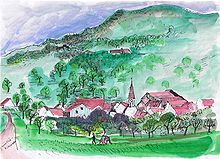
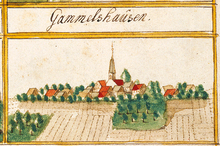
Gammelshausen is a municipality in the district of Göppingen in Baden-Württemberg . It belongs to the Stuttgart region (until 1992 the Middle Neckar region ) and the peripheral zone of the European metropolitan region of Stuttgart . Apart from the village of Gammelshausen, no other places belong to the community.
geography
Geographical location
Gammelshausen is 385 to 722 meters above sea level on the Albtrauf , about nine kilometers south of the district town of Göppingen . The highest point in the municipality is on Sielenwang .
Neighboring communities
Neighboring communities are Heiningen , Eschenbach , Bad Ditzenbach , Gruibingen , Dürnau and Lotenberg, which belongs to Eschenbach (all of the district of Göppingen).
Division of space

According to data from the State Statistical Office , as of 2014.
history
Surname
The place name can be traced back to an earlier Alemannic clan leader Gamold . Today's Gammelshausen developed from the earlier Gamoltzhusen .
20th century
In the competition Our village should become more beautiful , the community of Gammelshausen achieved a gold medal in the state and national competition in 1975.
Religions
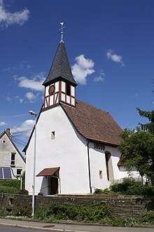
The Protestant church in the center of the village is a branch church in the church district of Göppingen , for which the Dürnau parish is responsible. Politically, Gammelshausen shared the fortunes of the neighboring town of Dürnau, to which it has also been part of the church since 1798 (previously to Boll), until 2012 as an independent parish. A chapel of St. Maria is mentioned in Gammelshausen in 1436. The current church was built in 1700, but has older parts. The parish of Gammelshausen was looked after by the Dürnau parish before the merger.
Population development
Source: Baden-Württemberg State Statistical Office for data from 1970
| date | Residents |
|---|---|
| 1837 | 286 |
| 1907 | 344 |
| May 17, 1939 | 307 |
| September 13, 1950 | 412 |
| May 27, 1970 | 688 |
| December 31, 1983 | 1480 |
| May 25, 1987 | 1485 |
| December 31, 1991 | 1529 |
| December 31, 1995 | 1562 |
| December 31, 2005 | 1415 |
| December 31, 2010 | 1464 |
| December 31, 2015 | 1429 |
politics
Municipal council
The municipal council in Gammelshausen has 10 members. The municipal council consists of the elected voluntary councilors and the mayor as chairman. The mayor is entitled to vote in the municipal council. The local elections on May 26, 2019 led to the following final result:
| Parties and constituencies |
% 2019 |
Seats 2019 |
% 2014 |
Seats 2014 |
||
| FWV | Free voter association Gammelshausen | 54.47 | 5 | 54.28 | 5 | |
| BWV | Civil voters' association Gammelshausen | 45.53 | 5 | 45.72 | 5 | |
| total | 100.0 | 10 | 100.0 | 10 | ||
| voter turnout | 68.60% | 58.7% | ||||
coat of arms
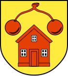
The blazon of the municipal coat of arms of Gammelshausen reads: In gold under a pair of red cherries, a red house .
The cherry pair of part speaking arms indicates growing cherries, which is operated in Gammelshausen. The house stands for the second part of the name in the place name Gammelshausen. The coat of arms and the red and yellow municipal flag were awarded on October 9, 1959 by the Ministry of the Interior.
Partnerships
Gammelshausen has had a partnership with Breil / Brigels in the canton of Graubünden in Switzerland since 1983 .
sport and freetime
At the northern end of Gammelshausen there is a soccer field. Together with the neighboring municipality of Dürnau , Gammelshausen operates a sports and leisure center, which is located in Dürnau on the outskirts of Gammelshausen. Above the community on the Galgenbuckel is an event space that is regularly used for various events such as solstice bonfires. The place is a good starting point for mountain bike tours in the surrounding mountains Fuchseck , Sielenwang , Köpfle and Kornberg .
societies
- Bowling club Gammelshausen; the first women's team currently plays in the 2nd Bundesliga, the first men's team in the association league.
Economy and Infrastructure

traffic
Gammelshausen is connected by country roads with Heiningen , Dürnau , Gruibingen and the Auendorf belonging to Bad Ditzenbach . The connection points Aichelberg and Mulhouse the motorway A 8 are approximately 9 km away. There are several bus routes in Gammelshausen, with which you can u. a. can get to the district town of Göppingen .
Public facilities
The parish hall, completed in 1976, is located near the town hall. There is a bowling alley and, since 2000, a youth room. Gammelshausen also has a public bakery.
education
Gammelshausen does not have its own schools or kindergartens. The Gammelshausen children visit the shared facilities in the neighboring community of Dürnau . These are only about one kilometer away from the outskirts.
Attractions
In Gammelshausen there is an educational fruit trail that was inaugurated in 1974 and runs as far as Dürnau. In more recent times, the first Swabian Spruchweg was added.
Trivia
For the residents of Gammelshausen, the nickname "Spaltela" is passed down. This name supposedly comes from the fact that in the past the young men of Gammelshausen drove away foreign competitors who wanted to hook up with Gammelshausen women by throwing logs at them, in Swabian "Spalterla".
Personalities
- Aloys Henn (1902–1988), Gammelshausen-born publisher, local politician and honorary district administrator
literature
Claus Anshof: “I don't believe in what I see!” Believable and unbelievable stories from a Swabian village . Gammelshausen community, 1986
Individual evidence
- ↑ State Statistical Office Baden-Württemberg - Population by nationality and gender on December 31, 2018 (CSV file) ( help on this ).
- ↑ State Statistical Office, area since 1988 according to actual use for Gammelshausen.
- ↑ gammelshausen.de: A sympathetic community , Gammelshausen community, accessed January 11, 2009
- ^ Website of the Evangelical Church Community Dürnau-Gammelshausen
- ↑ Info on the Internet description of the municipality ( Memento of the original from February 12, 2012 in the Internet Archive ) Info: The archive link was inserted automatically and has not yet been checked. Please check the original and archive link according to the instructions and then remove this notice.


