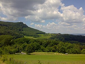
Fox corner
| Fox corner | ||
|---|---|---|
|
The Fuchseck seen from the Gairenhof (2009) |
||
| height | 760.9 m above sea level NHN | |
| location | Baden-Wuerttemberg , Germany | |
| Mountains | Swabian Alb | |
| Coordinates | 48 ° 38 '15 " N , 9 ° 41' 12" E | |
|
|
||
| rock | White Jura | |

The Fuchseck is 760.9 m above sea level. NHN high vantage point on the northern edge of the Swabian Alb and a striking spur of the Albtrauf south-east of Eschenbach and west of Gammelshausen . The Fuchseck is not a pronounced peak, the highest point of the spur is rather a bulge of the spur plateau near the Rottelstein at 780.3 m above sea level. NHN , which is about 500 meters southwest of the Fuchseck and from which the terrain slopes monotonously and without any noteworthy notch height to the Spornspitze. This is where the district boundaries of the communities Schlat (Ostabfall), Heiningen (Westabfall) and Bad Ditzenbach (plateau) meet. Neighboring mountains are the Wasserberg in the east across the Gairenbuckel pass of the L 1218 from Schlat to Reichenbach im Täle , to which the terrain slowly drops over the Hochberg foothills , and the Sielenwang in the southwest.
In 2008, the Eschenbach nature sports group set up a panoramic viewing platform with information boards at the Fuchseck. Among other things, it explains why this place is also called Dr.-Theodor-Engel-Ruhe . The Fuchseck offers a view of the three Kaiser Mountains and the Voralb area.
The Swabian Alb Nordrand-Weg (HW 1), a long-distance hiking trail run by the Swabian Alb Association , leads over the Fuchseck . The Fuchseck is particularly popular with mountain bikers and hikers. The ascent from Eschenbach is considered the most difficult and steepest.
Individual evidence
- ↑ a b Map services of the Federal Agency for Nature Conservation ( information )
- ↑ Geoportal Baden-Württemberg: Geodata Viewer ( Memento of the original from May 7, 2016 in the Internet Archive ) Info: The archive link was inserted automatically and has not yet been checked. Please check the original and archive link according to the instructions and then remove this notice.
- ↑ Bad Ditzenbach newsletter, volume 37, 2008, page 3 PDF file


