Kornberg (Gruibingen)
| Kornberg | ||
|---|---|---|
|
Kornberg near Gruibingen |
||
| height | 779.7 m above sea level NHN | |
| location | Baden-Wuerttemberg , Germany | |
| Mountains | Swabian Alb | |
| Coordinates | 48 ° 37 '11 " N , 9 ° 38' 1" E | |
|
|
||
| rock | White Jura | |
| particularities | Nature reserve | |
The Kornberg is a 779.7 m above sea level. NHN high mountain on the Albtrauf , the northern edge of the Swabian Alb . The summit of the mountain is in the district of Gruibingen in the district of Göppingen .
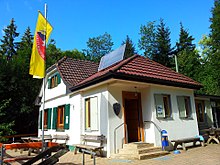
The Kornberghütte, completed in 1922, is located southeast of the summit . Not far north of the Kornberg, on a protruding spur, is the Burg Landsöhr castle , which is part of the Bad Boll district and is also known colloquially as Bertaburg . The long-distance hiking trail Schwäbische Alb-Nordrand-Weg (HW 1) leads past the Kornberg .
Kornberg nature reserve
With the ordinance of the regional council of Stuttgart of July 15, 2004 the Kornberg and its southern foothills Barn were designated as nature reserve Kornberg under number 1.262 . The nature reserve covers an area of 189.8 ha. Protection purpose is
- the maintenance and promotion of an ecologically diverse, small-scale and networked landscape with juniper heaths , succession areas , hedges, extensively used species-rich meadows, some fields and farm meadows and natural deciduous forests with the typical, sometimes endangered animal and plant species;
- the preservation of a cultural landscape as a witness to partly historical forms of use, in particular the preservation of the juniper heaths and the extensively managed meadows;
- the preservation of a particularly varied, charming and typical landscape section of the Swabian Alb.
The area contains the FFH habitat types 5130 (formations of Juniperus communis on limestone heaths and lawns), 6510 (poor lowland hay meadows), 9130 (woodruff beech forests) and 9150 (orchid beech forests).
Former quarry
There used to be a quarry on the northeastern edge of the Kornberg, which was filled up after it was closed. The area is now used as a campsite. In the past, a cable car ran from the quarry to Dürnau , from where the demolition material was transported on via a rail connection.
See also
Individual evidence
- ↑ Map services of the Federal Agency for Nature Conservation ( information )
- ↑ Kornberghütte: www.kornberghuette.de
- ↑ Burgstelle Landsöhr: Medieval castle locations and aristocratic residences in the district of Göppingen ( Memento from November 28, 2014 in the Internet Archive )
- ↑ Schwäbische-Alb-Nordrand-Weg: http://www.schwaebischer-albverein.de/wandern/wanderwege/weitwanderwege/hw1/weggeschichte_hw1.pdf ( Memento from May 14, 2012 in the Internet Archive )
- ↑ Protected area profile . Retrieved August 25, 2018 .
- ↑ Kornberg youth camp: YMCA scouts Esslingen. In: pfadfinder.cvjm-esslingen.de. Archived from the original on August 29, 2016 ; accessed on August 29, 2016 . Info: The archive link was inserted automatically and has not yet been checked. Please check the original and archive link according to the instructions and then remove this notice.
- ^ Förderverein Eislinger Saurierfunde eV: Jurassic Sea and more. In: www.foerderverein-eislinger-saurierfunde.de. Retrieved August 29, 2016 .


