
Old hut
| coat of arms | Germany map | |
|---|---|---|

|
Coordinates: 48 ° 55 ' N , 9 ° 34' E |
|
| Basic data | ||
| State : | Baden-Württemberg | |
| Administrative region : | Stuttgart | |
| County : | Rems-Murr district | |
| Height : | 497 m above sea level NHN | |
| Area : | 18.15 km 2 | |
| Residents: | 4206 (December 31, 2018) | |
| Population density : | 232 inhabitants per km 2 | |
| Postcodes : | 71566, 71549 | |
| Primaries : | 07183, 07192 | |
| License plate : | WN, BK | |
| Community key : | 08 1 19 004 | |
| Address of the municipal administration: |
Rathausplatz 1 71566 Althütte |
|
| Website : | ||
| Mayor : | Reinhold Sczuka | |
| Location of the municipality of Althütte in the Rems-Murr district | ||
  |
||

Althütte is a municipality in the Rems-Murr district in Baden-Württemberg .
geography
Geographical location
Althütte has a share in the natural areas Schurwald and Welzheimer Wald as well as Swabian-Franconian Forest Mountains , both of which belong to the Swabian Keuper-Lias-Land . The state-approved resort is located in the Swabian-Franconian Forest Nature Park at an altitude of 334 to 572 meters. The highest elevation of Althütte, the Hohenstein near Sechselberg, is at the same time the highest elevation of the Murrhardt Forest , the part of the Swabian-Franconian Forest Mountains that includes the Althütte.
Neighboring communities
Neighboring communities Althüttes are (clockwise) Murrhardt in the north, Kaisersbach in the east, Rudersberg in the south and Weissach in the valley and Auenwald in the west (all Rems-Murr-Kreis).
Community structure
The municipality of Althütte with the districts of Althütte and Sechselberg consists of the following villages , hamlets , farms and residential areas :
The Althütte district includes the village of Althütte, the hamlets of Kallenberg, Lutzenberg, Schöllhütte (which have grown together structurally with Althütte since 1971) and Voggenhof and the Nonnenmühle homestead.
The district of Sechselberg includes the village of Sechselberg, the hamlets of Fautspach, Gallenhof , Hörschhof, Schlichenhöfle, Schlichenweiler and Waldenweiler, the farms Glaitenhof, Hörschhofer Sägmühle and the residential area Rottmansberger Sägmühle.
Division of space
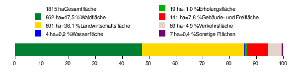
According to data from the State Statistical Office , as of 2014.
history


middle Ages
The Sechselberg , first mentioned in 1027, was probably founded around the year 800 and came to Württemberg in the 14th century to the Ebersberg office.
The Althütte districts of Lutzenberg 1407, Kallenberg 1408 and Schöllhütte 1459 were first mentioned in a document . Until the founding of the community in 1819, the localities of the Althütte district were under the jurisdiction of staff and courts in Unterweissach . The place name Althütte , like many other place names in the Swabian-Franconian Forest, with the name component -hütte refers to the production of forest glass in glassworks . The village emerged from one of these glassworks that had existed here until the end of the 16th century and was first mentioned in 1459. This was an accessory for Reichenberg Castle . The remains of a glassworks were found during excavations.
Modern times
The local population also specialized in the production of wooden rakes , of which around 40,000 are said to have been made here in 1855.
The Althütte community was founded in 1819, as was the Sechselberg community. Both belonged to the Oberamt Backnang in the Kingdom of Württemberg and in the Free People's State of Württemberg . During the district reform during the Nazi era in Württemberg , the villages came to the Backnang district in 1938 . After 1945 the municipalities in the state of Württemberg-Baden were in the American zone of occupation and since 1952 in the new state of Baden-Württemberg .
Swechselberg was incorporated into Althütte on July 1, 1971.
As a result of the district reform in Baden-Württemberg , the municipality of Althütte came from the dissolved Backnang district to the Rems-Murr district on January 1, 1973 .
politics
Municipal council
The local council in Althütte has 14 members. The local elections on May 26, 2019 led to the following final result. The municipal council consists of the elected voluntary councilors and the mayor as chairman. The mayor is entitled to vote in the municipal council.
| Parties and constituencies |
% 2019 |
Seats 2019 |
% 2014 |
Seats 2014 |
||
| FWV | Free electoral association | 55.28 | 8th | 52.33 | 7th | |
| BL | Citizen List | 25.16 | 3 | 28.29 | 4th | |
| FA 2000 | Forum Althütte 2000 | 19.56 | 3 | 19.38 | 3 | |
| total | 100.0 | 14th | 100.0 | 14th | ||
| voter turnout | 65.09% | 57.85% | ||||
Partnerships
Althütte maintains partnership relationships with Obertilliach in East Tyrol in Austria .
Infrastructure
traffic
The state roads L 1119 and L 1120 run through the municipality. The next motorway junction is the Mundelsheim junction of the federal motorway 81 , about 32 km away via Großbottwar .
The public transport is ensured by buses, which in the Stuttgart area at standard rates in the Transport and Tariff Association Stuttgart run.
The nearest train stations are in Murrhardt and Backnang , approx. 11 km and 15 km away on the Waiblingen – Schwäbisch Hall-Hessental railway line .
Long-distance cycle routes
The German Limes Cycle Route runs through the district of Fautspach . It follows the Upper German-Raetian Limes over 818 km from Bad Hönningen on the Rhine to Regensburg on the Danube .
Sons and daughters of the church
- Anna Haag (1888–1982), politician and women's rights activist
- Ernst Leverkus (1922–1998), motorcycle journalist and author
Individual evidence
- ↑ State Statistical Office Baden-Württemberg - Population by nationality and gender on December 31, 2018 (CSV file) ( help on this ).
- ↑ Natural areas of Baden-Württemberg . State Institute for the Environment, Measurements and Nature Conservation Baden-Württemberg, Stuttgart 2009.
- ↑ Geoportal Baden-Württemberg ( references ) on a scale of 1: 10,000. A smaller value of 569.3 m above sea level. NN on some maps is not at the highest point, but at a fork in the road.
- ^ The state of Baden-Württemberg. Official description by district and municipality. Volume III: Stuttgart District, Middle Neckar Regional Association. Kohlhammer, Stuttgart 1978, ISBN 3-17-004758-2 , pp. 504-505.
- ↑ State Statistical Office, area since 1988 according to actual use for Althütte.
- ^ Federal Statistical Office (ed.): Historical municipality directory for the Federal Republic of Germany. Name, border and key number changes in municipalities, counties and administrative districts from May 27, 1970 to December 31, 1982 . W. Kohlhammer, Stuttgart / Mainz 1983, ISBN 3-17-003263-1 , p. 446 .
- ^ Election information from the Stuttgart municipal data center
Web links

Alfdorf | Allmersbach im Tal | Althütte | Aspach | Floodplain forest | Backnang | Berglen | Burgstetten | Fellbach | Großerlach | Kaisersbach | Kernels in the Remstal | Kirchberg an der Murr | Basket | People Bach | Murrhardt | Oppenweiler | Plüderhausen | Remshalden | Rudersberg | Schorndorf | Schwaikheim | Spiegelberg | Sulzbach an der Murr | Urbach | Waiblingen | Weinstadt | Weissach im Tal | Welzheim | Winnenden | Winterbach