
Alfdorf
| coat of arms | Germany map | |
|---|---|---|

|
Coordinates: 48 ° 51 ' N , 9 ° 43' E |
|
| Basic data | ||
| State : | Baden-Württemberg | |
| Administrative region : | Stuttgart | |
| County : | Rems-Murr district | |
| Height : | 487 m above sea level NHN | |
| Area : | 68.52 km 2 | |
| Residents: | 7085 (December 31, 2018) | |
| Population density : | 103 inhabitants per km 2 | |
| Postcodes : | 73553, 73655 | |
| Primaries : | 07172, 07171 | |
| License plate : | WN, BK | |
| Community key : | 08 1 19 001 | |
| LOCODE : | DE ARF | |
| Address of the municipal administration: |
Obere Schlossstrasse 28 73553 Alfdorf |
|
| Website : | ||
| Mayor : | Ronald Krötz | |
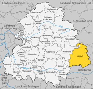
| Location of the municipality of Alfdorf in the Rems-Murr district | ||
  |
||

Alfdorf is a municipality in the Rems-Murr district in Baden-Württemberg .
geography
Geographical location

Alfdorf is about ten kilometers northwest of Schwäbisch Gmünd and 40 kilometers northeast of Stuttgart . The varied landscape of the municipality (altitude from 308 to 560 m above sea level) is located in the Swabian-Franconian Forest nature park with beautiful viewpoints of the Dreikaiserberge and the Swabian Alb, the valleys with the many water mills and the extensive forests, invites you to hike and relax, a cultivated gastronomy to linger. The Welzheimer Forest is in the immediate vicinity .
expansion
The community with its 63 suburbs and districts stretches over a marked area of approx. 6,852 hectares from Adelstetten in the east to Tannhof in the west, from Haselbach in the south to Hellershof in the north.
Neighboring communities
Adjacent to the area Alfdorfs the north Gschwend , east Spraitbach , Durlangen and Mutlangen , south of Schwabisch Gmund and Lorch (all Ostalbkreis ) in the West Plüderhausen , Urbach and Welzheim and in the northwest Kaiserbach (all Rems-Murr-Kreis ).
Community structure

The community of Alfdorf with the districts of Alfdorf, Pfahlbronn , Rienharz and Vordersteinenberg consists of 64 villages , hamlets , farms and houses :
The Alfdorf district includes the village of Alfdorf, the hamlets of Bonholz and Haselbach and the farms Leinhalden, Maierhof, Maierhofer Sägmühle, Schölleshof, Strübelhof and Strübelmühle.
The Pfahlbronn district includes the village of Pfahlbronn, the hamlets of Adelstetten, Brech, Buchengehren, Enderbach, Haselhof and Mittelweiler, the Leinecksmühle and Schenkhöfle farms and the Buchengehrener Sägmühle, Gehäuhaus, Haldenhof, Pfahlbronner Mühle and Voggenberger Sägmühle.
The hamlet Rien resin hamlets Brend, castle wood Haghof, Höldis belong Holz , Rien resin Schmidhof, Tannhof and Voggenberg, the courtyards Burgholzhof, Döllenhof, Fritzhof, Hagmühle, Meuschenmühle, Niederheckenhof, and Schmid Höfle and the houses Burgholzer Sägmühle, Haghofer Ölmühlehof, man Holzer Oil mill, Rienharzer saw mill and Voggenberg mill.
The Vordersteinenberg district includes the villages of Vordersteinenberg, Hintersteinenberg and Kapf , the hamlets of Bruckhof, Hellershof, Hüttenbühl, Steinhaus, Tennhöfle and Wahlenheim, the farms Deschenhof, Dornhalden, Greuthöfle, Greuthof, Hafental, Heinlesmühle, Pfahlenhof, Schotthof, and the house, Stixenhof and Vai Neuwirtshaus.
In the Alfdorf district is the abandoned Haselhof farm.
In Alfdorf the municipal council is elected according to the procedure of the false suburbs . For this purpose, the four districts of Alfdorf, Pfahlbronn, Rienharz and Vordersteinenberg form residential districts within the meaning of the Baden-Württemberg municipal code .
Division of space

According to data from the State Statistical Office , as of 2014.
climate
The annual precipitation is 1044 mm. Precipitation is high and is in the upper quarter of the values recorded in Germany. Lower values are registered at 87% of the measuring stations of the German Weather Service . The driest month is February, with the most rainfall in June. In June there is 1.6 times more rainfall than in February. The rainfall varies greatly. Lower seasonal fluctuations are registered at 71% of the measuring stations.
Population structure
The proportion of foreigners is 6.4%.
6610 of the 7062 inhabitants of Alfdorf are advertised by the State Statistical Office as residents of German origin. 452 residents are of foreign origin.
history

The Romans built from the year 150 AD between the Rhine at Koblenz and the Danube at Regensburg the Upper Germanic-Rhaetian Limes . This border line to the Germanic peoples also ran through the west of today's municipal area of Alfdorf. From the north-northwest, the Limes ran in a straight line over a length of 80 kilometers from the vicinity of Walldürn in the Odenwald to the Alfdorf district of Haghof , where it initially turned abruptly to the east and then swiveled again to the south shortly before the neighboring Alfdorf district of Pfahlbronn, and then to the Strive towards Remstal near Lorch. The next forts were in what is now the city of Welzheim (in the north) and Lorch (in the south). In the municipality of Alfdorf, the Romans built several watchtowers along the Limes, the foundation walls of some of them are still preserved.
The Seventeen near Welzheim are 17 farms from Altersberg, Nardenheim, Seelach, Hintersteinenberg, Vordersteinenberg, Deschental, Wighartsrüte, Kapf and Krettenbach, which today belong to Alfdorf and Gschwend. According to a widespread but refuted legend, in the late Middle Ages they had their own jurisdiction including their own place of execution.
Alfdorf was created during the older expansion period and was first mentioned in a document in 1143, when Bishop Walther von Augsburg confirmed a foundation to the Anhausen an der Brenz monastery ; this property went to the Lorch monastery in 1327 .
In the village of Pfahlbronn, the remains of Leineck Castle lie in a south loop of the Lein on the lower slope of the Bergsporn and just north of the Leinecksmühle .
Until 1805, Alfdorf was a knightly estate of the von Holtz family (since 1628) in the knightly canton of Kocher . In 1805 Alfdorf came under the sole sovereignty of Württemberg and in 1807 was first assigned to the Gmünd Oberamt and finally to the Welzheim Oberamt in 1810 . The administrative reform during the Nazi era in Württemberg led to membership in the Schwäbisch Gmünd district in 1938 . In 1945 the place became part of the American zone of occupation and thus belonged to the newly founded state of Württemberg-Baden , which was incorporated into the current state of Baden-Württemberg in 1952. Today's community was created on January 1, 1972 through the merging of the communities of Alfdorf, Pfahlbronn and Vordersteinenberg. Through the district reform in Baden-Württemberg , Alfdorf came to the newly formed Rems-Murr district in 1973 . In 1971, the state parliament of Baden-Württemberg found a majority of 56 to 55 votes for this decision.
politics
Municipal council
The municipal council in Alfdorf has 22 members. The municipal council consists of the elected voluntary councilors and the mayor as chairman. The mayor is entitled to vote in the municipal council. The local elections on May 26, 2019 led to the following final result:
| Parties and constituencies |
% 2019 |
Seats 2019 |
% 2014 |
Seats 2014 |
||
| FW | Free voters | 55.1 | 12 | 62.1 | 11 | |
| CDU | Christian Democratic Union of Germany | 23.7 | 5 | 37.9 | 7th | |
| UB | Independent citizens | 21.3 | 5 | - | - | |
| total | 100.0 | 22nd | 100.0 | 18th | ||
| voter turnout | 65.0% | 55.1% | ||||
Coats of arms of the districts

Pfahlbronn

Vordersteinenberg

Alfdorf (from 1980)


Town twinning
On August 12, 2011, Alfdorf and the Hungarian municipality of Hosszúhetény entered into a partnership, and on October 2, 2011 with the Thuringian municipality of Reinstädt .
Culture and sights


Buildings
On the territory of the municipality Alfdorf of Haghofs ends near one in Walldürn incipient, 81 km long, straight running south-southeast section of the Limes Germanicus , of the UNESCO - World Heritage belongs. Along the route of the old border, hikers can follow in the footsteps of the Romans on the Limes hiking trail (HW 6) of the Swabian Alb Association . The Mühlenwanderweg also leads through the Alfdorf municipality and touches a number of historic mills , including the Heinlesmühle, the Voggenbergmühle and the Hummelgautsche. The Meuschenmühle, which was built in 1787, is also on the hiking trail. The half-timbered structure of the mill building was restored in 2019, as was the mill wheel. Operations ceased in 1970. Nevertheless, part of the mill equipment is functional and can be viewed.
Another attraction is the Stephanuskirche , which was completed in 1776 .
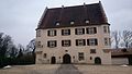
There are two castles in Alfdorf. The new, so-called Upper Castle, is located in the castle park and is now the seat of the municipal administration. The old, better known as the Lower Castle , was built around 1550 on the edge of the Swiss Valley. The builders were the lords of Neuhausen .
The building at Obere Schlossstrasse 43 , built in the middle of the 19th century, housed a privately operated local history museum until the end of the 2000s .
Applied arts
Alfdorf has a long tradition in the pottery trade . In its heyday, Alfdorf potters also delivered their goods to the court in Stuttgart . The old handicraft is still practiced in a traditional way today.
Regular events
- Alfdorf Street Festival (September)
- Alfdorf light market (November)
Economy and Infrastructure
traffic
Alfdorf is part of the Stuttgart Transport and Tariff Association and is part of the OstalbMobil network tariff . The nearest train stations are Lorch (Württ) and Schwäbisch Gmünd on the Remsbahn (Stuttgart– Aalen ), eight and twelve kilometers from Alfdorf, respectively. State roads establish the connection to the national road network ( B 14 in Backnang or Waiblingen, B 29 in Lorch or Schwäbisch Gmünd and A 7 near Aalen, through the B 29 feeder).
Established businesses

ZF Friedrichshafen AG employs around 1,800 people in Alfdorf.
Astorplast Klebetechnik AG , based in Alfdorf, has existed since the mid-1960s, produces technical pressure-sensitive adhesive tapes and employs around 120 people (as of 2010).
education
In Alfdorf there is a primary and secondary school with a Werkrealschule . In the suburbs of Pfahlbronn and Hellershof there is one further elementary school each . The next secondary schools and high schools are in Welzheim, Lorch and Mutlangen. In addition to nine kindergartens, Alfdorf also has a music school and an adult education center.
religion
In Alfdorf there is a Protestant church (St. Stephanus Church), a Catholic church (St. Clemens Maria Hofbauer), a New Apostolic Church, an Evangelical Methodist church, as well as the Alfdorf People's Mission and the Alfdorf People's Mission and the Apis.
Resident associations
The TSV 1921 Alfdorf was founded on March 15, 1921 as the Alfdorf gymnastics club . In 1927 he built a gymnasium and festival hall, which was also used by schools and other clubs. However, this passed into the ownership of the municipality in 1935. In 1947 the association was re-established under its current name. In 1952, the soccer department separated as FC Alfdorf , whose men's department plays in the district league B1 for the 2018/2019 season . The sports facilities in Alfdorf include a gymnasium and festival hall, a sports hall (currently closed for renovation work), a stadium with a tartan track and several tennis courts. The sports facilities in Pfahlbronn include two grass courts, several tennis courts and the club home of the Bundesliga team of the Pfahlbronn friends of tug-of-war. The sports facilities in Vordersteinenberg include two grass courts, four tennis courts and the club house of the Hintersteinenberg sports club.
Personalities
Sons and daughters of the church
- Gottfried Kinkel (1871–1932), member of the Württemberg state parliament
- Wilhelm Weismann (1900–1980), composer and musicologist
- Max Krämer (* 1990), German men's golf champion 2011
- Florian Schöbinger (* 1986), former handball player in the Bundesliga (currently: San Francisco CalHeat Team Handball Club)
- Fabian Bruck (* 1992), musician
Personalities who work on site
- Rüdiger Gamm (* 1971), memory and mental trainer

Town Hall (Upper Castle)

Arch to the Stephanuskirche
Lower castle, seat of the von Holtz family

Old Town Hall

Pottery Schöffel


Individual evidence
- ↑ State Statistical Office Baden-Württemberg - Population by nationality and gender on December 31, 2018 (CSV file) ( help on this ).
- ↑ How to reach Alfdorf: Municipality of Alfdorf. Retrieved May 15, 2019 .
- ↑ How to reach Alfdorf: Municipality of Alfdorf. Retrieved May 15, 2019 .
- ^ The state of Baden-Württemberg. Official description by district and municipality. Volume III: Stuttgart District, Middle Neckar Regional Association. Kohlhammer, Stuttgart 1978, ISBN 3-17-004758-2 , pp. 493-497.
- ↑ TK 50; Sheet L 7124 "Schwäbisch Gmünd".
- ^ Main statute of the municipality of Alfdorf from May 19, 1998, last amended on September 21, 2009
- ↑ State Statistical Office, area since 1988 according to actual use for Alfdorf.
- ↑ Population by nationality - quarterly. Statistical State Office Baden-Württemberg, September 30, 2018, accessed on March 16, 2019 .
- ^ Federal Statistical Office (ed.): Historical municipality directory for the Federal Republic of Germany. Name, border and key number changes in municipalities, counties and administrative districts from May 27, 1970 to December 31, 1982 . W. Kohlhammer, Stuttgart / Mainz 1983, ISBN 3-17-003263-1 , p. 455 .
- ↑ How Alfdorf quickly changed the district , in: 60 Jahre Gmünder Tagespost ( online )
- ^ Election information for the community of Alfdorf .
- ↑ Coat of arms of Alfdorf - detail page - LEO-BW. Retrieved May 15, 2019 .
- ↑ Partnership agreement signed . Alfdorf and Hosszuheteny now have an official partnership. In: Municipality of Alfdorf (Ed.): Official Journal Alfdorf . Pfahlbronn and Hintersteinenberg. No. 34 . Einhorn-Verlag, Schwäbisch Gmünd August 25, 2011, p. 1 .
- ↑ Amelie Seck: Driven by wind and water - Schwäbische Mehlfabrik , In: Monumente , edition 3/2020, page 21.
- ↑ Heimatmuseum Alfdorf , kunst-und-kultur.de, accessed July 24, 2011.
- ↑ Ask landowners if they are interested , Gmünder Tagespost , article from October 14, 2009.
- ↑ Alfdorfer pottery , Alfdorf community, accessed on June 18, 2017.
- ↑ Astorplast: Chairman of the Supervisory Board becomes CEO , Heilbronn-franken-wirtschaft.de, accessed September 17, 2010.
- ^ Club chronicle of the TSV ( Memento from January 2, 2014 in the Internet Archive ), Turn- und Sportverein Alfdorf 1921 e. V., accessed November 29, 2010.
- ^ Sports facilities: Municipality of Alfdorf. Retrieved May 15, 2019 .
Web links
- ditto von Vorder-Steinenberg in the description of the Oberamt Gaildorf from 1852
- Alfdorf at LEO-BW

Alfdorf | Allmersbach im Tal | Althütte | Aspach | Floodplain forest | Backnang | Berglen | Burgstetten | Fellbach | Großerlach | Kaisersbach | Kernels in the Remstal | Kirchberg an der Murr | Basket | People Bach | Murrhardt | Oppenweiler | Plüderhausen | Remshalden | Rudersberg | Schorndorf | Schwaikheim | Spiegelberg | Sulzbach an der Murr | Urbach | Waiblingen | Weinstadt | Weissach im Tal | Welzheim | Winnenden | Winterbach