
Same lake
| Same lake | |||||||
|---|---|---|---|---|---|---|---|
 |
|||||||
|
|||||||
|
|||||||
| Coordinates | 49 ° 8 '2 " N , 9 ° 32' 29" E | ||||||
| Data on the structure | |||||||
| Height of the barrier structure : | 3.5 m | ||||||
| Crown length: | 210 m | ||||||
| Data on the reservoir | |||||||
| Altitude (at congestion destination ) | 422 m above sea level NN | ||||||
| Water surface | 1.4 ha | ||||||
| Reservoir length | 140 m | ||||||
| Reservoir width | 210 m | ||||||

The Gleichener Lake (also known as New Gleichener lake called) is a 1.4 ha large reservoir in Baden-Wuerttemberg ( Germany ), about 5.6 km southeast of Pfedelbach in mainhardt forest .
geography
The Gleichener See lies on the edge of the Swabian-Franconian Forest Nature Park and is located in the district of Pfedelbach im Hohenlohekreis at 422 m above sea level. NN . The Gleichener See shows all natural silting belts from the open water to the reed stands, large and small sedge meadows up to the initial stages of raised bog. There are three small islands in it. The water is no more than 2 m deep, the length of the dam is approximately 210 m and the water surface takes up about 13,000 m². It takes its name from the town of Gleichen . The Volkersbach rises from the Gleichener See.
history
In the 18th century, Hohenlohe-Pfedelbach and Hohenlohe-Bartenstein bought farm ownership in Gleichen to create a zoo and a new lake. In 2003 the lake was drained and desludged. The lake is located in the Mainhardt Forest and has been an FFH area of the European Union since 2004 . The route of the Upper German-Raetian Limes , which has been on the UNESCO World Heritage List since 2005, runs through Lake Gleichen . Digital terrain models , which were generated on the basis of data collected from Lidar measurement flights in 2009 , show two buildings in the ground relief near Lake Gleichen, which could be small Roman forts based on the ground plan .
Old Gleichener Lake
A so-called Alter Gleichener See is located in Obergleichen and is now just a pond . There were 96 shares in the Alten Gleichener See. The Pfedelbach community has acquired all the shares in recent years. In 2014, the Alt Gleichener See was renatured by the municipality of Pfedelbach.

The old Gleichener See in Obergleichen

The new Gleichener See

The new Gleichener See
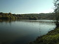
The new Gleichener See


literature
- Gerhard Taddey (Red.): Pfedelbach 1037–1987. From past and present (= research from Württembergisch-Franken. Vol. 30). Published by the Pfedelbach community. Thorbecke et al., Sigmaringen et al. 1987, ISBN 3-921429-30-7 .
Individual evidence
- ^ Website of the Pfedelbach community with information on Lake Gleichen (accessed October 30, 2009)
- ↑ Stephan Bender: Traces of small forts at Lake Gleichen? (PDF; 3.3 MB) In: The Limes. Volume 3, Issue 2, 2009, ISSN 1864-9246 , pp. 10-11, (accessed on January 23, 2010).