
Hörschbach (Murr)
|
Hörschbach left upper course : Mähderbach |
||
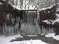
 Hörschbachtal in winter |
||
| Data | ||
| Water code | DE : 23838154 | |
| location |
Swabian-Franconian forest mountains
|
|
| River system | Rhine | |
| Drain over | Murr → Neckar → Rhine → North Sea | |
| confluence |
Mähderbach (left) / Langenwaldbach (right) about 0.7 km northwest of the hamlet of Hörschhof von Althütte 48 ° 57 ′ 30 ″ N , 9 ° 32 ′ 56 ″ E |
|
| Source height | approx. 410 m above sea level NHN confluence of the upper reaches
|
|
| muzzle | in western Murrhardt from the left and south into the upper Murr Coordinates: 48 ° 59 ′ 5 ″ N , 9 ° 33 ′ 39 ″ E 48 ° 59 ′ 5 ″ N , 9 ° 33 ′ 39 ″ E |
|
| Mouth height | approx. 282 m above sea level NHN | |
| Height difference | approx. 128 m | |
| Bottom slope | approx. 23 ‰ | |
| length | 5.5 km confluence of the upper reaches |
|
| Catchment area | 8.818 km² | |
The Hörschbach is a 5 km long stream with its longer upper course Mähderbach in the Rems-Murr-Kreis in northeastern Baden-Württemberg , which flows into the Murr from the left and south in Murrhardt . The right source stream is called Langenwaldbach . The Hörschbach is well known for its two waterfalls , the upper rear and the lower front waterfall .
geography
course
The Hörschbach rises in the southern Murrhardt Forest and runs quite steadily in a northerly direction. It is fed by two brooks, of which the left Mähderbach is called and the right Langenwaldbach , at the very top perhaps also the Mähderbach ; both arise on the plateau of the Murrhardt Forest north and east of Sechselberg (municipality of Althütte ). Most of the water in the left brook consists of treated wastewater from the municipality of Sechselberg, as the brook serves as a receiving water for the sewage treatment plant. The streams flow on both sides of the Hörschhof in a northerly direction until, after about a kilometer at the edge of the forest, they begin to cut deeply into the plateau. The steep gradient at these points gave rise to the construction of two sawmills , the Rottmannsberger sawmill on the left and the Hörschhöfer sawmill on the right stream.
Within the next 600 meters, both streams lose 40 meters in height and merge at the rear waterfall. The left brook falls over a hard sandstone bank, initially three meters in free fall and then in cascades a further nine meters into the depth. Once at the bottom, it meets the right source stream, which falls over its own, smaller waterfall into the gorge. On the left Bach lies directly above the waterfall a reservoir can be emptied the (popularly called "Kläpple") with a small flap to at low water for a short time an impressive, by offset drop steps gischtreichen to observe waterfall.
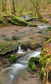
The now united stream continues to flow in a northerly direction through a narrow gorge. On this two-kilometer section, he is accompanied by a narrow, unpaved path that can only be walked with sturdy shoes and sometimes also leads over stepping stones in the water. There are many hikers on this section of the stream, as it connects the rear with the front waterfall, which is at the lower end of the path. Here the Hörschbach falls over an erosion-resistant layer of the gypsum keuper 5 m in a hollow.
Less than a kilometer later, the Hörschbach leaves the forest and soon flows into the Murr coming from the east in the western settlement area of the city of Murrhardt .
Catchment area
The dewatered Hörschbach an area of 8.8 square kilometers, which predominantly in murrhardt forest lies with the lowermost parts little upstream of the mouth in Bitzer , Geographically seen both subspaces of Schwäbisch-Fränkischen Waldberge . The highest point is above the Althüttener Gallenhof at about 567 m above sea level. NHN at a water reservoir on the northern slope of the Hohenstein , which is 572 m above sea level at the summit . Reached NHN .
The right watershed from here to the mouth separates initially from the upper source brooks of the Murr in the east, after the summit of the Hoblersberg ( 539.2 m above sea level ) then from the little upstream of the Hörschbach also in the settlement area of Murrhardt into the upper Murr flowing Großkehbach . Along the left watershed from Hohenstein to the mouth of the river, first in the southwest the right upper course Glaitenbach of the large tributary Weißach of the middle Murr, then the deeper Weißach tributary Brüdenbach in the west, in the northwest the latter, the larger brook still from the left into the upper Murr Eschelbach flowing in , almost all via tributaries. Behind the northern border of the catchment area, on this side of the Hörschbach, only insignificant sloping streams run to the Murr.
Tributaries and lakes
Hierarchical list of tributaries and ![]() lakes from source to mouth. Length of water, lake area, catchment area and altitude according to the corresponding layers on the LUBW online map. Other sources for the information are noted. Selection.
lakes from source to mouth. Length of water, lake area, catchment area and altitude according to the corresponding layers on the LUBW online map. Other sources for the information are noted. Selection.
Confluence of Hörschbachs to about 410 m above sea level. NHN under the rear waterfall in the beginning Hörschbach gorge about 0.7 km northwest of the Hörschhof.
-
Mähderbach , left and southern main strand upper reaches, 2.1 km and approx. 2.1 km². Arises at about 483 m above sea level. NHN on the northern edge of Sechselberg ( 48 ° 56 ′ 43 ″ N , 9 ° 32 ′ 59 ″ E ).
- (Inflow from a small wood), from the right and east to about 468 m above sea level. NHN at the Sechselberger sewage treatment plant, 0.4 km and approx. 0.2 km². Arises below 490 m above sea level. NHN west of the forest sports field north of Gallenhof .
- Seebach , from the left and at about 451 m above sea level. NHN at the Rottmannsberger Sägmühle, 1.0 km and about 0.7 km². Arises below 485 m above sea level. NHN a little northwest of Sechselberg on the edge of the woods .
- Rear waterfall (of the Mähderbach), less than 0.2 km before the confluence.
-
Langenwaldbach , maybe (only on the upper course?) Also Mähderbach , right and southeastern main course upper course, 1.8 km and about 1.3 km². Arises at about 493 m above sea level. NHN at the edge of the forest north of Gallenhof.
- (Waldbach), from the right and east-northeast to about 467 m above sea level. NHN next to the Fautspach - Hörschhof road , 0.6 km and approx. 0.2 km². Arises at about 488 m above sea level. NHN in the forest area Storchwiese at the southern foot of the Hoblersberg .
- (Waldbach), from the right and east-northeast to about 464 m above sea level. NHN again in the forest below the street mentioned, 0.4 km and below 0.1 km². Arises at about 505 m above sea level. NHN on the southwest slope of the Hoblersberg in the Langenwald forest .
- (Waldbach), from the right and east-northeast to about 462 m above sea level. NHN at the beginning of the small clearing at the Hörschhofer Sägmühle , 0.6 km and approx. 0.1 km². Arises at about 510 m above sea level. NHN on the southwest slope of the Hoblersberg in the Langenwald forest .
- (Waldbach), from the right and east-northeast to about 445 m above sea level. NHN again in the forest below the small clearing, 0.6 km and below 0.2 km². Arises at about 515 m above sea level. NHN at the western slope of the Hoblersberg in the forest Won Hoblersberg .
- Rear waterfall (of the Langenwaldbach), less than 0.1 km before the confluence.
- (Waldklingenbach), from the right and east-southeast to about 380 m above sea level. NHN in the Hörschbach Gorge, 0.6 km and approx. 0.4 km². Rises at about 485 m above sea level. NHN on the northwest slope of the Hoblersberg in the Mühlhalde forest area next to the Hörschhofer Sägmühle- Waltersberg forest path .
- Saubächle , from the left and west-northwest to over 360 m above sea level. NHN in the Hörschbach Gorge, 1.5 km and approx. 0.8 km². Arises at about 483 m above sea level. NHN in Waldgewann Kohl between the clearing islands around the Trailhof and around Siebenknie .
- Front waterfall
-
Seebach , from the left to about 322 m above sea level. NHN at the former Hörschbachmühle , 2.0 km and approx. 1.1 km². Arises at about 485 m above sea level. NHN a little southwest of Siebenknie at the edge of the forest.
-
 Flows through at about 478 m above sea level. NHN a little southeast of Siebenknie a pond dammed behind a path, 0.1 ha.
-
- → (exit of the mill canal of the Schwarzenmühle), to the right to about 310 m above sea level. NHN right after the last change in the hallway.
- Siebenkniebach , from the left to about 298 m above sea level. NHN just below the Schwarzenmühle, 1.6 km and approx. 0.6 km². Arises inconsistently at about 475 m above sea level. NHN at a fork in the field a little northeast of Siebenknie.
- ← (return of the mill canal of the Schwarzenmühle ), from the right to about 298 m above sea level. A few meters after the previous one, 0.3 km and below 0.1 km².
- (Graben), from the right and south-southeast to about 292 m above sea level. NHN next to the K 1808 Siebenknie – Murrhardt, 0.8 km and approx. 0.2 km². Arises at about 380 m above sea level. NHN on the Waltersberg slope under the hiking trail on the middle slope from the Vordere Wasserfall to Murrhardt.
Mouth of the Hörschbach from the left and west-southwest to about 282 m above sea level. NHN in the western urban area of Murrhardt in the upper Murr , a little above the Murr bridge there of the Murrbahn . The brook is 5.5 km with the longer left upper course Mähderbach , from its confluence with the right upper course Langenwaldbach another 3.3 km and drains an area of 8.8 km².
geology
The source streams of the Hörschbach arise in the upper Mittelkeuper above the silica sandstone ( Hassberge formation ). Shortly before they unite, they fall over hard sandstone banks at the rear waterfall. Plenty of sintered lime has deposited on the steps . The front waterfall falls further downwards over an edge formed by the dolomitized and therefore more erosion-resistant Corbula Bank (former name "Engelhofer Platte") of the deeper gypsum keuper ( Grabfeld formation ). The gypsum keuper is also the deepest Triassic layer in the catchment area. The stream then flows into the upper Murr in the Quaternary strip of floodplain sediment deposited on both sides of the river.
natural reserve
The Hörschbach lies entirely in the Swabian-Franconian Forest Nature Park . The two headwaters are in addition in the conservation area murrhardt forest . The areas from the entry into the forest at the two sawmills to the exit from the forest at Murrhardt, which have been combined in the 46.4 hectare Hörschbachschlucht nature reserve since 1995, are particularly protected .
According to the ordinance, the purpose of the nature reserve is "to preserve the gorge with its natural geological outcrops and striking rock formations as a scientifically remarkable geological phenomenon" as well as the preservation of natural habitats in the Keuperklingen and its natural forest. In fact, according to various counts, between 130 and 250 plant species live in the gorge; the fauna is enriched by stone crabs , brown trout , fire salamanders and dippers .
photos

Reservoir
Front waterfall
Hörschbach with hiking trail
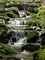
Water stairs in the Hörschbach valley


Individual evidence
LUBW
Official online waterway map with a suitable section and the layers used here: Course and catchment area of the Hörschbach
General introduction without default settings and layers: State Institute for the Environment Baden-Württemberg (LUBW) ( notes )
- ↑ a b c d e f g Height according to the contour line image on the background layer topographic map .
- ↑ a b c Length according to the waterway network layer ( AWGN ) .
- ↑ a b Catchment area according to the basic catchment area layer (AWGN) .
- ↑ Height according to black lettering on the background layer topographic map .
- ↑ Lake area after the layer standing waters .
- ↑ Catchment area measured on the background layer topographic map .
- ↑ Name Mähderbach for the upper right Hörschbach Headwaters of the map labels on the background layer topographical map and after the Layer WMS ATKIS Digital Topographical map on Geoportal Baden-Wuerttemberg ( notes ). The LUBW's own map layers, on the other hand, only and exclusively name this upper course Langenwaldbach .
Other evidence
- ↑ a b Geology roughly based on: Map server of the State Office for Geology, Raw Materials and Mining (LGRB) ( notes )
- ↑ Hansjörg Dongus : Geographical land survey: The natural spatial units on sheet 171 Göppingen. Federal Institute for Regional Studies, Bad Godesberg 1961. → Online map (PDF; 4.3 MB)
- ↑ Geotope profile of the rear waterfall
- ↑ Geotope profile of the front waterfall
literature
- Topographic map 1: 25,000 Baden-Württemberg, as single sheet No. 7023 Murrhardt
- Topographic map 1: 50,000 Baden-Württemberg, sheet L 7122 Backnang
- Hiking map Schwäbisch Hall - Backnang , M = 1: 35,000, publisher Schwäbischer Albverein , sheet 8, ISBN 978-3-920801-75-9
- Paul Strähle: Swabian-Franconian Forest Nature Park . Revised by Theo Müller . 4th, revised and expanded edition. Theiss, Stuttgart 2006, ISBN 3-8062-2033-6 .
- Dieter Buck: excursion destination Swabian-Franconian Forest. Hiking - cycling - discovering . Silberburg-Verlag, Tübingen 2005, ISBN 3-87407-648-2 .
Web links
- Map of the course and catchment area of the Hörschbach on: State Institute for the Environment Baden-Württemberg (LUBW) ( information )
- Tourist map of the Hörschbach Gorge on: Geoportal Baden-Württemberg ( information )
- Measuring table sheet 7023 Murrhardt from 1903, 2010 in the Deutsche Fotothek
- State Office for the Environment, Measurements and Nature Conservation - List of Protected Areas
- Hiking map and description from the "WanderWalter"