
Weißach (Murr)
|
Weißach upper reaches: Glaitenbach, Brucher Bach |
||
 The bike and footpath to the school center runs parallel to the river under the road between Aichholzhof and Seemühle / Weissach in the valley. |
||
| Data | ||
| Water code | DE : 238384 | |
| location |
Neckar basin
|
|
| River system | Rhine | |
| Drain over | Murr → Neckar → Rhine → North Sea | |
| source | Confluence of several streams at Oberweissach 48 ° 55 ′ 24 ″ N , 9 ° 30 ′ 13 ″ E |
|
| Source height | 274 m above sea level NN | |
| muzzle | near Backnang in the Murr Coordinates: 48 ° 56 '54 " N , 9 ° 26' 46" E 48 ° 56 '54 " N , 9 ° 26' 46" E |
|
| Mouth height | 244 m above sea level NN | |
| Height difference | 30 m | |
| Bottom slope | 2.4 ‰ | |
| length | 12.3 km with OL Glaitenbach | |
| Catchment area | 52.549 km² | |
The Weißach is a 12 km long left tributary of the Murr in Baden-Württemberg with its main upper course . It arises from several streams in the eastern part of the Backnang Bay and runs entirely in the Rems-Murr district .
Surname
The name "Weißach" is of Germanic origin and characterizes the water as a stream with white, d. H. foaming water. The brook was first mentioned in 1027 in a document from Emperor Conrad II as "Wizzaha".
In addition to the spelling "Weißach", which is used on official topographic maps, the spelling "Weissach" is also in use. The latter form appears in the names of the towns of Unterweissach and Oberweissach, which are located on the creek and which are combined with other places in the Weissach im Tal community. The addition to the name “im Tal” refers to the name “Weissacher Tal”, which is used for the entire catchment area of the stream with all its side valleys, to which the communities Allmersbach im Tal and Auenwald also belong.
course
The Weißach flows together from numerous small brooks that arise in the eastern half of the Backnang Bay on the edge of the Keuper lower level. The course of the brook from Oberweissach, where the Glaitenbach, the Däfernbach and the Buchwiesenbach (the latter both flow over their common short lower course Brucher Bach) is called Weißach. With a length of 5.8 km, the Glaitenbach is the slightly longer upper branch, but the Bucher Bach contributes a sub-catchment area that is more than half the size.
Between the Weissach districts of Oberweissach and Aichholzhof, the stream crosses the nature reserve at Seegut (see below). At Aichholzhof it takes up the water of the Gruppenbach stream coming from the south, which in turn has a clump of differently named upper courses, and then changes its direction of flow permanently from west to northwest. After flowing through Unterweissach, the stream runs for a long time over the open fields, reaching the harder shell limestone soils and merging into a winding course characteristic of this layer. The Weißach passes the Sachsenweiler district of Backnang on the right slope . On the eastern outskirts of Backnang, at the former Adolff spinning mill (now an industrial park), it flows 6.3 km downstream from the confluence of its upper reaches near Oberweissach from the left into the middle Murr.
Tributaries
From the source to the mouth. Selection, partly also with higher inflows.
Origin of the Weißach on the eastern edge of Oberweissach from the confluence of the Glaitenbach and the Däfernbach , which shortly before received the Bucher Bach .
- Glaitenbach , right upper reaches of the Weißach, 6.0 km and 5.6 km². Arises in a blade south of Sechselberg.
-
Brucher Bach , left upper course of the Weißach, 0.1 km, with longer own right upper course Däfernbach together 5.2 km and 9.0 km².
- Däfernbach , right upper reaches of the Brucher Bach, 5.1 km and approx. 4.9 km². Made in a blade at Schöllhütte.
- Bubwiesenbach , left upper reaches of the Brucher Bach, 3.6 km and approx. 4.0 km². Made in a blade near Lutzenberg.
- Wattenbach , from the left in the Seegut-Semmlersberg nature reserve , 3.8 km with the upper reaches of Seelöchlesbach and 2.4 km².
-
Gruppenbach , from the left opposite the Aichholzhof, 1.4 km and together with each of its two upper reaches 4.7 km and 11.6 km². The Weißach bends at this tributary to the northwest.
- Horbach , left upper course of the Gruppenbach, 3.3 km and 2.5 km². Created at Horbach
- Allmersbach , right upper reaches of the Gruppenbach, 3.3 km and 4.3 km². Created under the Stöckenhof in Öschelbronn.
- Horbetsbach , from the left in Unterweissach between Welzheimer and Stuttgarter Strasse, 2.2 km and about 1.7 km².
-
Brüdenbach , from the right in Unterweissach near the town hall, 7.3 km with its upper reaches Alter Haubach and 13.9 km². The old Haubach is being built south of Siebenknie.
- Heslachbach , from the left in Oberbrüden , 2.8 km and approx. 3.0 km². Develops near the Trailhöfle.
- Holzbach , from the left in Unterbrüden , 3.4 km and approx. 2.1 km². Originates near Rottmannsberg.
- Hametsbächle , from the right just before the Lower Mill of Unterweissach, 0.8 km and approx. 0.4 km²
- Dresselbach , from the right at the beginning of Sachsenweiler, 1.7 km and about 1.6 km².
- Mädlesbach , from the left a stone's throw after the previous one, 1.1 km, together with an inconsistent upper course Etzlensbach , below which the course is initially diluted , even about 1.5 km and about 1.6 km². The Etzlensbach arises between the sports fields on the eastern edge of Backnang and the Ungeheuerhof.
- (Bach from the northern edge of Sachsenweiler), from the right through Sachsenweiler to the sewage treatment plant, 0.9 km and about 0.6 km².
Mouth of Weißach in eastern Backnang through an industrial zone around the Eugen-Adolf-Straße. The brook is 6.3 km long from the source brook confluence, from the source of the Glaitenbach furthest away from the mouth it is 12.3 km long and has an area of influence of 52.5 km.
Catchment area
The catchment area of the Weißach lies in the eastern half of the Backnang Bay. It forms a distinctive, semicircular valley basin surrounded by the mountains of the Swabian-Franconian Forest , which is strongly divided by the many small, incised streams. In the north it is the Murrhardter Wald , in the east the Welzheimer Wald , and in the south it is the mountains , on the steep slopes of which the tributaries of the Weißach arise. The catchment area is a good 50 km² and extends (clockwise) from the Brüdenbach in the north to the Horbach in the southwest. The Brüdenbach, which flows into Unterweissach, is also the longest tributary at 7.3 km. Neighboring catchment areas of the Weißach are several other tributaries of the Murr and the Wieslauf in the southeast.
Todays use
traffic
The Weissacher Tal, a bulge of the Neckar basin , lies in the traffic shadow of the larger connecting paths that run on the edge of the valley via Backnang. Only a few district roads run through the area, in the valley of the Weißach itself between Unterweissach and up to Däfern (municipality of Auenwald).
State of development
The Weißach is classified as a second order body of water along its entire length . According to the Water Act for Baden-Württemberg, this means that the river bed is the public property of the municipalities concerned and that they are responsible for maintaining the water body.
Individual sections of the tributaries are twisted within the places through which they flow . B. the Glaitenbach in Lippoldsweiler and the Allmersbach in the place of the same name. The Weißach itself is also routed underground through the old spinning mill just before its mouth.
To cope with flood protection, the three communities in the Weissacher Valley founded a joint association in 2000. In addition to drafting an overall concept for flood protection, it is the task of the association to build and operate a series of retention basins , most of which are still to be built.
natural reserve
The eastern and northern edges of the Weissacher Valley are part of the Swabian-Franconian Forest Nature Park , and the slopes on the southern and eastern edges are extensively protected as the Southern Weissacher Tal and Berglen landscape protection area.
In 1999 the landscape protection area between Oberweissach and Aichholzhof was upgraded and declared a nature reserve. This NSG Seegut-Semmlersberg covers an area of 18.3 hectares on both sides of the Weißach. According to the Nature Conservation Ordinance, this area is "one of the last larger wetlands in the Rems-Murr district with floodplain forest and reed areas" of great ecological importance. Also worth mentioning are several impact slopes in the Muschelkalk section near Sachsenweiler, which are considered to be extensive natural monuments .
In the 2004 water report, the water of the Weißach and some tributaries were examined. While the Däfernbach in the village of Däfern was able to certify quality class I-II ("slightly polluted") and for the Gruppenbach (in Cottenweiler) and Brüdenbach (in Unterweissach) it was still enough for class II ("moderately polluted"), the Weißach itself had to in Unterweissach the predicate "critically polluted" (Class II-III) are awarded, making it one of the most polluted waters in the Murr catchment area.
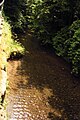
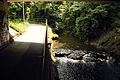
Pictures from the Weißach
Shortly after the tributary of the Gruppenbach
Under the Aichholzhof – Seemühle road bridge

The mouth of the Brüdenbach (from the left) into the Weißach (from behind) in Unterweissach

The long bridge in Unterweissach

View from the New Bridge in Unterweissach towards the Long Bridge

After Unterweissach at the lower mill

On the slope at the foot of Sachsenweiler

Entry to the site of the former Adolff spinning mill
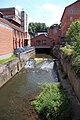
View from the bridge in the spinning mill area just before the estuary

View up the river Weissach over the confluence with the Murr


Individual evidence
- ↑ a b c State Institute for the Environment Baden-Württemberg (LUBW) ( information )
- ^ History of the community Weissach im Tal
- ↑ Name of the Etzlensbach derived from that of the eponymous Gewann am Lauf.
- ↑ Water Act for Baden-Württemberg in the version of January 20, 2005 ( page no longer available , search in web archives ) Info: The link was automatically marked as defective. Please check the link according to the instructions and then remove this notice. (PDF, 717 KB)
- ^ Statutes of the special purpose association "Flood Protection Weissacher Tal" (PDF file; 26 kB)
- ↑ State Office for the Environment, Measurements and Nature Conservation - Protected Areas Directory ( Memento of the original from July 29, 2017 in the Internet Archive ) Info: The archive link has been inserted automatically and has not yet been checked. Please check the original and archive link according to the instructions and then remove this notice.
- ↑ Biological water quality map 1: 350,000 of the State Institute for Environmental Protection Baden-Württemberg (PDF; 11.7 MB)
Further geographical information according to official topographic maps 1: 25,000 and 1: 50,000
Web links
- Map of Weißach and its catchment area on: State Institute for the Environment Baden-Württemberg (LUBW) ( information )
-
Geoportal Baden-Württemberg ( information ), especially with the partial maps / layers
- the State Institute for the Environment, Measurements and Nature Conservation Baden-Württemberg (LUBW)
- "LUBW-FG10": River 1: 10,000
- "LUBW-GEZG": water catchment areas
- the State Institute for the Environment, Measurements and Nature Conservation Baden-Württemberg (LUBW)