
Floodplain forest
| coat of arms | Germany map | |
|---|---|---|

|
Coordinates: 48 ° 56 ' N , 9 ° 30' E |
|
| Basic data | ||
| State : | Baden-Württemberg | |
| Administrative region : | Stuttgart | |
| County : | Rems-Murr district | |
| Height : | 280 m above sea level NHN | |
| Area : | 19.76 km 2 | |
| Residents: | 6779 (December 31, 2018) | |
| Population density : | 343 inhabitants per km 2 | |
| Postal code : | 71549 | |
| Primaries : | 07191, 07192 | |
| License plate : | WN, BK | |
| Community key : | 08 1 19 006 | |
| LOCODE : | DE UAD | |
| Address of the municipal administration: |
Lippoldsweiler Strasse 15 71549 Auenwald |
|
| Website : | ||
| Mayor : | Karl Ostfalk | |
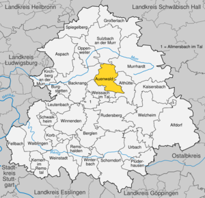
| Location of the municipality of Auenwald in the Rems-Murr district | ||
  |
||

Auenwald is a municipality in the Rems-Murr district in Baden-Württemberg . The seat of the municipal administration is in the Unterbrüden suburb.
geography
Geographical location
Auenwald is located on the eastern edge of the natural area Neckarbecken belonging Backnanger bay against the murrhardt forest , which forms part of the natural environment -Schwäbisch Franconian Forest forms. The municipality is located at an altitude of 269 to 520 meters and stretches from Löss to the west and Gipskeuper to the east of the Brüdenbach (tributary to the Murr ) over reed and silica sandstone on the Keuperrand up to the Stubensandstein of the Murrhardt Forest, without reaching tuberous marl or Black Jura .
Neighboring communities
Alluvial forest borders Backnang in the northwest, Sulzbach an der Murr in the north, Murrhardt in the northeast, Althütte in the southeast and Weissach in the valley in the southwest.
Community structure
The community Auenwald consists of 16 villages, hamlets, farms and houses and was formed in the 1970s from the four previously independent communities Ebersberg , Lippoldsweiler , Oberbrüden and Unterbrüden .
To Ebersberg include the village of Ebersberg and the Ebersberg Castle .
To Lippoldsweiler include the village Lippoldsweiler, the hamlet Däfern and scorn hamlet and the farm Sauerhof.
To Oberbrüden include the village Oberbrüden, the hamlet Heslachhof, Mittelbrüden, Rottmann Mountain, Tiefental, Trailhof, Trail Höfle and Utzenhof and the living space Schmoll mill.
To Unterbrüden the village belongs Unterbrüden.
The abandoned village of Schnarrenberg is in the Hohnweiler area .
Division of space

According to data from the State Statistical Office , as of 2014.
history
Brüden and Rottmannsberg, which today belongs to Oberbrüden , were first mentioned in 1245 in a document from Pope Innocent IV . In the course of the late Middle Ages, most of the area of today's municipality came to Württemberg and was the responsibility of the Backnang office. However, individual localities were pledged to other rulers by the Württemberg rulers. So in 1439 Unterbrüden with the Reichenberg Castle was pledged to the Hohenberg emergency. After the Reformation took place in Altwürttemberg in 1534, only the town of Ebersberg returned to the Catholic faith in 1654 at the behest of the Winterstetten taverns , which at the time owned Ebersberg Castle . All places of today's municipality of Auenwald belonged to the Oberamt Backnang at the time of the Kingdom of Württemberg . During the district reform during the Nazi era in Württemberg , the villages came to the Backnang district in 1938 . In 1945 the area became part of the American zone of occupation and thus belonged to the newly founded state of Württemberg-Baden , which was merged into the present state of Baden-Württemberg in 1952. After the war, settlements of refugees and displaced persons emerged in Lippoldsweiler and Unterbrüden, where mainly Hungarian and Sudeten Germans found a new home. On January 1, 1971, Ebersberg was incorporated into Lippoldsweiler. On July 1, 1971, Lippoldsweiler, Oberbrüden and Unterbrüden merged to form the new municipality of Auenwald. In 1973 the district reform took place in Baden-Württemberg , when the Auenwald became part of the Rems-Murr district.
Religions
Since Schenk von Winterstetten introduced the Counter-Reformation in Ebersberg in 1654, this part of the village is the only one that is still Roman Catholic today; the rectory next to the Herz-Jesu-Kirche , which is located in the Lippoldsweiler district, is the administrative seat of the Catholic parish Auenwald-Althütte and is responsible not only for Auenwald but also for the Catholics of the Althütte community . In the other districts, the Evangelical Lutheran denomination prevails with churches in Oberbrüden ( Peterskirche ), Unterbrüden ( Kreuzkirche ) and Lippoldsweiler (Lutherkirche). After all, there is a New Apostolic congregation each in Lippoldsweiler and Unterbrüden .
politics
Municipal council
The municipal council in Auenwald has 18 members. The municipal council consists of the elected voluntary councilors and the mayor as chairman. The mayor is entitled to vote in the municipal council. The local elections on May 26, 2019 led to the following final result:
| Parties and constituencies |
% 2019 |
Seats 2019 |
% 2014 |
Seats 2014 |
Local elections 2019
% 40 30th 20th 10
0
37.24%
26.32%
22.81%
13.63%
BWA
NLA
UWA
FWA
Gains and losses
compared to 2014
% p 30th 25th 20th 15th 10 5
0
-5 -10 -15 -13.09 % p
+ 26.32 % p.p.
-3.60 % p
-3.17 % p.p.
BWA
NLA
UWA
FWA
|
|
| BWA | Civic voter association Auenwald | 37.24 | 7th | 50.33 | 9 | |
| NLA | New Auenwald list | 26.31 | 5 | - | - | |
| UWA | Independent voter community Auenwald | 22.81 | 4th | 26.41 | 5 | |
| FWA | Auenwald Free Electoral Association | 13.63 | 2 | 16.80 | 3 | |
| SPD | Social Democratic Party of Germany | nk | - | 6.46 | 1 | |
| total | 100.0 | 18th | 100.0 | 18th | ||
| voter turnout | 64.44% | 52.89% | ||||
Community partnerships
A partnership between Auenwald and Beaurepaire in the Isère department in the Auvergne-Rhône-Alpes region , France, has existed since 1987 .
Culture and sights
music
Since 1985, three classical concerts have been held annually under the title Ebersberg Concerts in the district of the same name.
Buildings
- The remains of the Hohenstaufen castle Ebersberg lie above the suburbs Ebersberg and Lippoldsweiler. The castle was first mentioned in 1226. In 1551 the two- wing Ebersberg Castle was added, the remains of which can be seen in today's building. In 1714 a fire destroyed the palace complex. In the rebuilt building from 1719, the educational and meeting place of the German Scouting Society Saint Georg in the Diocese of Rottenburg-Stuttgart has been located since 1966 (no visits possible). From the mountain spur there is a beautiful view of the Backnang Bay with the Weissacher Valley .
- Lambachpumpanlage (Lambach pump), a water column machine that supplied the mountain community of Lutzenberg (now part of Althütte ) with water from 1928 to 1958 . It is located in the "Däfernwald" (near the Auenwald district of Däfern). The water from the Mastwiesen spring was pumped through a 30 m water column with the help of the machine the 130 m up to Lutzenberg. The Lambach pump was restored by the Bürgererverein Ebersberg eV and is still looked after and maintained by him to this day.
education
In Lippoldsweiler, Oberbrüden and Unterbrüden there is a primary school and several kindergartens . Secondary schools can be visited in Weissach im Tal .
Personalities
- Hermann Bäuerle (1869–1936), born in Ebersberg, Catholic theologian and church musician
- Karl Stolz (1913–2001), born in Unterbrüden, District Administrator, President of the Württemberg Savings Banks and Giro Association
- Karl Kühnle (1923–2003), born in Unterbrüden, 143rd District Apostle of the New Apostolic Church
Web links
Footnotes
- ↑ State Statistical Office Baden-Württemberg - Population by nationality and gender on December 31, 2018 (CSV file) ( help on this ).
- ^ The state of Baden-Württemberg. Official description by district and municipality. Volume III: Stuttgart District, Middle Neckar Regional Association. Kohlhammer, Stuttgart 1978, ISBN 3-17-004758-2 , pp. 508-510.
- ↑ State Statistical Office, area since 1988 according to actual use for alluvial forest.
- ^ Federal Statistical Office (ed.): Historical municipality directory for the Federal Republic of Germany. Name, border and key number changes in municipalities, counties and administrative districts from May 27, 1970 to December 31, 1982 . W. Kohlhammer, Stuttgart / Mainz 1983, ISBN 3-17-003263-1 , p. 446 .
- ^ Election information from the Stuttgart municipal data center .
- ↑ [1]

Alfdorf | Allmersbach im Tal | Althütte | Aspach | Floodplain forest | Backnang | Berglen | Burgstetten | Fellbach | Großerlach | Kaisersbach | Kernels in the Remstal | Kirchberg an der Murr | Basket | People Bach | Murrhardt | Oppenweiler | Plüderhausen | Remshalden | Rudersberg | Schorndorf | Schwaikheim | Spiegelberg | Sulzbach an der Murr | Urbach | Waiblingen | Weinstadt | Weissach im Tal | Welzheim | Winnenden | Winterbach