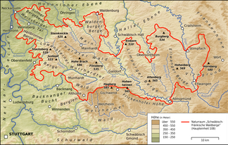
Sulmer mountain range
| Sulmer mountain range | ||
|---|---|---|
|
Sulmer mountain range in the north-west of the Swabian-Franconian Forest Mountains |
||
| Highest peak | Mountainous area ( 338.8 m above sea level ) | |
| location | Heilbronn district ; Baden-Württemberg ( Germany ) | |
| part of |
Löwenstein Mountains in the Swabian-Franconian Forest |
|
|
|
||
| Coordinates | 49 ° 12 ′ N , 9 ° 19 ′ E | |
| Type | Mountain country | |
| rock | Keuper | |


The Sulmer mountains in the Heilbronn district are up to 338.8 m above sea level. NHN high northern foothills of the Löwenstein Mountains in Baden-Württemberg . Together with the Heilbronner Mountains to the southwest, they are often referred to as the Heilbronner Bergland .
geography
location
The Sulmer mountain range forms the northern foothills of the Löwenstein mountains in the northwest of the Swabian-Franconian Forest Mountains.
The landscape stretches between the lower reaches of the Kocher in the northwest and north with Neuenstadt am Kocher , the lower reaches of the Brettach in the northeast and east with Langenbrettach , with the Hohenloher Plain to the northeast and the Mainhardt Forest to the east, beyond Bretzfeld , the lower reaches of the sulm in the south with the other side of the Weinberger valley in Weinberg and Erlenbach situated Heilbronner mountains and the middle reaches of the River Neckar in the west Neckarbecken with Neckarsulm and bath Friedrichshall .
The following localities are located within the landscape: Amorbach , Buchhorn , Cleversulzbach , Dahenfeld , Eberstadt , Gellmersbach , Holz , Oedheim , Schwabbach , Siebeneich and Wimmental .
Natural allocation
In terms of natural space, the Sulmer Bergebene (number 108.11) with the Weinsberger Valley (108.12) and the Heilbronner Mountains (108.13) as parts of the Löwenstein Mountains (108.1) in the Swabian Keuper-Lias-Land (10) belong to the Swabian-Franconian Forest Mountains (108 ).
mountains
The elevations and slope spurs of the Sulmer mountain range include - sorted by height in meters (m) above sea level (NHN):
- Bergebene ( 338.8 m ), 1.5 km southeast of Dahenfeld
- Geißberg ( 324.6 m ), 1 km southwest of Gellmersbach
- Wildenberg ( 316.4 m ), 1.5 km south of Eberstadt
- Scheuerberg ( 310.2 m ), 2.2 km east-northeast of Neckarsulm
- Sommerberg ( Stromberg ; 307.4 m ), 2.2 km north of Erlenbach
- Schauberg ( 303.8 m ), directly south of Dahenfeld
- Wooden level ( 296.3 m ), 1.3 km north-northeast of Holz
Flowing waters
The flowing waters of the Sulmer mountain range or its foothills include:
- Neckar , rises near Schwenningen , flows west of the mountain range through Neckarsulm and flows into the Rhine near Mannheim
- Kocher , rises on the Swabian Alb near Oberkochen , touches the mountain range to the north at Neuenstadt , flows northwestwards and flows into the Neckar at Bad Friedrichshall
- Brettach , rises near Mainhardt -Lachweiler, touches the mountain range east and northeast at Bretzfeld and Langenbrettach , flows northwest and flows into the Kocher at Neuenstadt
- Sulm , rises near Löwenstein, touches the mountain range southwest at Weinsberg in the Weinsberger Tal , flows northwest and flows into the Neckar at Untereisesheim
- Attichsbach , which rises as Lautenbach near Dahenfeld , leaves the mountain range, passing Amorbach with Plattenwald , westwards and flows into the Neckar at Neckarsulm
- Erlenbach , rises near the village of Erlenbach , leaves the mountain range southwards and flows into the Sulm in the village of Erlenbach
- Eberbach , which has its source near Holz , leaves the Sulmer mountain range flowing through Eberstadt and flows into the Sulm at the village of Erlenbach
- Schwabbach , which rises near Siebeneich , leaves the mountain range flowing through the village of Schwabbach and flows into the Brettach in Bretzfeld
- Sülzbach , rises near Wimmental , leaves the mountain range southwards and flows into the Sulm near Sülzbach
- Sulzbach , rises above Cleversulzbach , leaves the mountain range northwards and flows below Cleversulzbach into the Brettach
geology
From a geological point of view, the Sulmer Bergebene ranks as part of the Löwenstein Mountains in the Swabian Keuper-Lias-Land to the Germanic Triassic of the Mesozoic and can be assigned to the Keuper, i.e. it was formed about 220 million years ago. Their surveys are isolated Black Jura hilltops that the Knoll marl rest. The Heilbronn sandstone comes from their landscape .
nature
Flora and economy
The Sulmer mountain range is particularly forested in its high areas, and viticulture and agriculture are practiced in lower areas .
Protected areas
Be in the Sulmer mountain plain, part of the 54.27 km² large Fauna Flora Habitat type region Löwensteiner and Heilbronner mountains (FFH no. 7021-341) and parts of 23.91 square kilometers of FFH area Lower Jagst and lower Kocher (FFH No. 6721-341). There are also the Sulzbachtal-Berg conservation area, founded in 1982 and covering 0.65 km², and the LSG Brettachtal, founded in 1986 and measuring 2.58 km² . In addition, the 0.49 km² nature reserve Wildenberg, founded in 1992, is located on the edge of the landscape .
Worth seeing and cultural
The attractions and distinctive spots of the Sulmer mountain range and its foothills include:
- Brambacher Hof , Hofgut near Kochertürn
- Lautenbach , farm near Oedheim
- Oedheim military airfield , near Oedheim
- Wood tunnel ( A 81 ), for wood
Individual evidence
- ↑ a b c Map services of the Federal Agency for Nature Conservation ( information )
- ↑ Natural spatial main units of Germany - natural area numbers 10-19 , on wikipedia.de


