
Abtsgmünd
| coat of arms | Germany map | |
|---|---|---|

|
Coordinates: 48 ° 54 ' N , 10 ° 0' E |
|
| Basic data | ||
| State : | Baden-Württemberg | |
| Administrative region : | Stuttgart | |
| County : | Ostalbkreis | |
| Height : | 375 m above sea level NHN | |
| Area : | 71.6 km 2 | |
| Residents: | 7417 (Dec. 31, 2018) | |
| Population density : | 104 inhabitants per km 2 | |
| Postal code : | 73453 | |
| Area code : | 07366 | |
| License plate : | AA, GD | |
| Community key : | 08 1 36 002 | |
| LOCODE : | DE AGD | |
| Address of the municipal administration: |
Rathausplatz 1 73453 Abtsgmünd |
|
| Website : | ||
| Mayor : | Armin Kiemel | |
| Location of the community of Abtsgmünd in the Ostalb district | ||
  |
||

Abtsgmünd is a municipality at the confluence of the Lein and Kocher rivers in the Ostalbkreis in eastern Baden-Württemberg . The large community consists of the main town Abtsgmünd and the five sub-towns Neubronn, Laubach, Untergröningen , Hohenstadt and Pommertsweiler and a few other localities and hamlets. The community is a state-approved resort in the Swabian-Franconian Forest Nature Park .
geography
Geographical location
Abtsgmünd has a share in the natural areas of the Eastern Alb foreland and the Swabian-Franconian Forest Mountains , both of which are part of the Swabian Keuper-Lias-Land . With 71.6 km², the municipality of Abtsgmünd is the largest municipality in the Ostalb district after the towns .
The main town Abtsgmünd lies at the mouth of the river Lein in the Kocher. The suburb of Untergröningen lies in two river bends on both sides of the Kocher at 372 m above sea level. NN in eastern Baden-Württemberg.
Neighboring communities
Abtsgmünd borders in a clockwise direction in the north on Adelmannsfelden , in the east on Neuler and a small exclave of Hüttlingen , in the south-east on Aalen , in the south on Heuchlingen , in the south-west on Schechingen and Obergröningen , in the west on Eschach (all Ostalbkreis ) and in the north-west on Sulzbach -Laufen ( district of Schwäbisch Hall ).
Community structure

The formerly independent communities Abtsgmünd, Hohenstadt , Laubach , Neubronn , Pommertsweiler and Untergröningen with a total of almost 80 villages , hamlets , farms and houses belong to the current municipality of Abtsgmünd .
- The Abtsgmünd part of the municipality includes the village of Abtsgmünd, the hamlets of Altschmiede, Hangendenbuch, Neuschmiede, Schäufele, Vorderbüchelberg, Wilflingen and Wöllstein, the Birkholz farmstead and the Ausägmühle, Fischbach, oil and sawmill and powder mills.
- The village of Hohenstadt, the hamlets of Börrat, Butzenberg, Christhäuser, Kocherhof, Köhrhof, Maisenhäuser, Reichertshofen, Rötenbach, Schafhäuser and Steinreute and the farms Bernhardtshof, Brastelhof, Fischhaus, Frauenhof and Sandhof are in the Hohenstadt district.
- The village of Laubach, the hamlets of Berg, Haag and Leinroden, the village of Roßnagel, the farms of Blumenhof, Eichhornhof, Kauhof and Schneiderhaus and the residential area of Lustenau are located in the Laubach part of the municipality.
- The village of Neubronn and the farms Eiderhalden, Kellerhaus and Spatzenmühle are located in the Neubronn part of the municipality.
- In the municipality of Pommertsweiler are the village of Pommertsweiler, the hamlets Hinterbüchelberg, Höfenhölzle, Hohenhöfen, Lutstrut, Seelach, Straßdorf, Wildenhäusle, Wildenhof and Zimmerberg, the farms Altweiher, Hammerschmiede, Herrenwald, Mittelhohlenbach (partly also to the municipality Untergröningen), Neumühle and Oberhohlenbach residential area (partly also to the Untergröningen part of the municipality).
- In the municipality of Untergröningen are the village of Untergröningen, the hamlets of Billingshalden (Schweizerhof), Burren, Dinkbühl, Letten, Öchsenhof, Rötenbach, Rötenberg and Wegstetten and the residential areas Amselhöfle, Bach, Gschwendhof, Herrenfeld, Märzenhäusle, Mittelhohlenbach (partly also to the municipality of Pommertsweiler), Oberhohlenbach (partly also to the municipality of Pommertsweiler) and Tyrol.
Outbound , which no longer exists villages are Wisemberg (Bisems?) Bläsihof and a castle in the community town of Abtsgmünd, long pile in the community town of Neubronn, Buelenberg, Otolfsweiler, Deschental and lower caves creek in the community town of Pommertsweiler and Hurrenhof or stone Höfle, mill, saw-mill on Ochsenbach, when Gschwendhof , Steinhalden and Spitz in the Untergröningen part of the municipality.
Division of space
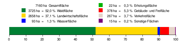
According to data from the State Statistical Office , as of 2014.
history
Until the 18th century
Abtsgmünd was probably founded from Ellwangen . The place gets its name from the confluence of the Lein in the Kocher and its affiliation to the monastery Ellwangen (The Gemunden of the abbot, in distinction to other Gemunden places ). This means that Abtsgmünd is very likely a Ellwangian foundation after the 7th century. An exact time is not known.
The Ellwangen monastery laid out the site to secure its forest area to the southwest. Abtsgmünd is mentioned with the name Gemunden in a property register of the Ellwangen Monastery from 1136. In the 13th century the name was changed to Abtzgemunde to avoid confusion with the later imperial city of Gmünd . The name first appeared in 1251 in a document from King Conrad IV .
The late Romanesque ground floor of the parish church tower, which was built around 1200, shows that the settlement existed earlier.
Wöllstein Castle was built from Abtsgmünd to secure the rule against the Limpurg taverns . The owners changed frequently, but the feudal sovereignty of the prince provost of Ellwangen remained. A Vogt, who was based in Wöllstein, was used for administration. In 1609 Heuchlingen , Abtsgmünd and Wöllstein formed the Ellwangische Amt Heuchlingen in the seat of the bailiff in Abtsgmünd.
As a member of the Prince Provosty of Ellwangen, Abtsgmünd remained Catholic during the Reformation , while the Kochertal from Schwäbisch Hall up to Untergröningen was reformed and evangelical in 1544 by the reformer Johannes Brenz .
In the 17th century the prince provosts founded iron works . In Abtsgmünd, a blast furnace was built in the old forge in 1611 and later a hammer forge . It went down in the Thirty Years' War , but was rebuilt in 1667 as a hammer forge. In 1699 the factory was relocated from the Altschmiede district to the Neuschmiede .
19th and 20th centuries
During the secularization , Abtsgmünd fell to the territories of Neuwuerttemberg in 1803 and came with them to the Kingdom of Württemberg in 1806 . The ironworks in Abtsgmünd merged with the Swabian ironworks based in Wasseralfingen . From 1803 to 1934 Abtsgmünd belonged to the Aalen District Office . During the administrative reforms during the Nazi era in Württemberg , Abtsgmünd came to the Aalen district in 1934 and to the newly structured Aalen district in 1938 . In 1945 the place became part of the American zone of occupation and thus belonged to the newly founded state of Württemberg-Baden , which was incorporated into the current state of Baden-Württemberg in 1952. Through the district reform in Baden-Württemberg in 1973, Abtsgmünd became part of the Ostalb district.
Incorporations
In the course of the municipality reform in Baden-Württemberg, five formerly independent municipalities were incorporated into Abtsgmünd. The size of the community and the number of residents more than doubled the size of the original community of Abtsgmünd.
| Incorporations | date | Marking area |
|---|---|---|
| Neubronn | 1st January 1971 | 473 ha |
| Laubach | 1st January 1971 | 479 ha |
| Untergröningen | 1st September 1971 | 1127 ha |
| Hohenstadt | February 29, 1972 | 1266 ha |
| Pommertsweiler | July 1, 1972 | 1762 ha |
| For comparison | Abtsgmünd | 2052 ha |
politics
Municipal council

The municipal council was last elected in the Baden-Württemberg municipal elections on May 26, 2019 with a fake partial location choice. It consists of 22 members whose term of office is five years. The seats are distributed among the individual parties and groups as follows. The turnout was 59.5% (2014: 53.8%).
| fraction | Election result | Strength | 2014 result |
|---|---|---|---|
| Free voters | 35.25% | 8 seats | 34.27%, 9 seats |
| CDU / UB | 36.55% | 8 seats | 33.42%, 8 seats |
| SPD | 28.20% | 8 seats | 32.31%, 8 seats |
coat of arms
Blazon : In a split shield in front in red a silver abbot's staff rising from the lower edge, with the curve turned towards the gap, in the back in silver three red balls one above the other.
The abbot's staff reminds of the place name as well as the monastery and prince provost of Ellwangen . The three red spheres come from the coat of arms of the Hack von Wöllstein, who had their castle seat in Abtsgmünd .
The municipality flag is white and red.
Between 1911 and 1917, Abtsgmünd adopted a seal image that showed an abbot's staff and a sword crossed diagonally over a town view in a divided shield, which were covered by a small shield. The little sign showed the Württemberg deer sticks . A continuous, overturned rafter bar stood for the Kocher and Lein rivers.
On November 26, 1956, the Baden-Württemberg Ministry of the Interior awarded the municipality the coat of arms and flag that are valid today.
Community logo
The community has had a community logo since the mid-1990s. On it is a green A for Abtsgmünd and the two rivers Lein and Kocher, at the mouth of which Abtsgmünd was once founded, are shown in blue as a dash of the letter A.
Partner communities
Abtsgmünd has had an official partnership with the Italian municipality of Castel Bolognese , Emilia-Romagna region , Ravenna province , since 2007 . Every year there is an exchange with the Italian twin city.
Judiciary
Abtsgmünd is in the district of the Aalen district court ; The District Court of Ellwangen and the Higher Regional Court of Stuttgart are superordinate to this within the ordinary jurisdiction . The competent court for labor jurisdiction is the Stuttgart Labor Court , and that for social justice is the Ulm Social Court . In addition, the Stuttgart Administrative Court is locally responsible for disputes under public law from Abtsgmünd .
Economy and Infrastructure
traffic
Abtsgmünd is on federal highway 19 between Aalen and Schwäbisch Hall . The connection to the federal motorway 7 at Westhausen is about 15 kilometers away. The Untergröningen district was the end point of the Upper Kocher Valley Railway from Gaildorf, which was closed in 2005 and largely dismantled in 2009 .
Established businesses
The defining company in the main town of Abtsgmünd is Kessler + Co. GmbH & Co. KG, a special factory that has existed since 1950 with over 400 employees for the production of axles and gearboxes for special vehicles.
In the suburb of Untergröningen, the company Holopack Verpackungstechnik GmbH is active, which manufactures products for the pharmaceutical industry or packs them in suitable containers.
Educational institutions
With the Friedrich-von-Keller-Schule , Abtsgmünd has a primary , secondary and secondary school , to which the Wasenschule , a pure primary school, also belongs as a branch . In addition, the St. Jakobus Gymnasium (sponsored by the “Catholic Free School Foundation of the Rottenburg-Stuttgart Diocese”) has been in operation since 2010. There are also primary schools in Hohenstadt, Pommertsweiler and Untergröningen. For the youngest residents of Abtsgmünd, there is a Roman Catholic kindergarten (St.Josef Kindergarten), two Protestant and a forest kindergarten which was opened in 2016.
Social facilities
- Senior Center Hallgarten of the Haus Lindenhof Foundation - nursing home
- Social station Abtsgmünd gGmbH - outpatient care service
Culture and sights
Because of its many sub-locations, there are numerous clubs and organizations in the entire community of Abtsgmünd.
Culture
- Laubach Castle Cultural Association
- Art in Untergröningen Castle - KISS
Attractions
The Catholic parish church of St. Michael Abtsgmünd is a neo-Gothic basilica with a late Romanesque tower basement. The Rechberg Cross has been erected in front of the church since 1994; this cross, dated 1331, is the second oldest stone cross in Baden-Württemberg. It was probably created by a sideline of the Counts of Rechberg .

St. Michael Church

Portal of the Church

Rechberg Cross


- The tiled room of Hohenstadt Castle was named Monument of the Month for February 2006 by the Baden-Württemberg Monument Foundation.
- The former tithe barn is now used as a library and event center.
- Castle and pilgrimage church of the Sacrifice of the Virgin Mary in Hohenstadt
- Lustgarten Hohenstadt, the oldest hedge garden in Europe
- Untergröningen Castle
- Laubach Castle
- Neubronn Castle
- Leinroden tower hill castle
- Jakobuskapelle Wöllstein

Tithe shy

"Lusthaus" in the palace garden of Abtsgmünd-Hohenstadt

Laubach Castle

Neubronn Castle

Leinroden tower hill castle


societies
- The Abtsgmünd local group of the Swabian Alb Association , founded in 1893, was awarded the Eichendorff plaque in 2003.
leisure
- Hammerschmiedesee Pommertsweiler
- Laubbach reservoir Abtsgmünd
- Hiking trails in the valley of the blind red
Personalities
Born in Abtsgmünd
- Konrad Adelmann von Adelmannsfelden (1462–1547), canon and humanist
- Caspar Adelmann von Adelmannsfelden (1464–1541), humanist and canon
- Johann Christoph Freiherr Adelmann von Adelmannsfelden (1640–1687), provost of the prince provost of Ellwangen
- Joseph Anselm Freiherr Adelmann von Adelmannsfelden (1728–1805), politician
- Jakob Salat (1766–1851), theologian and philosopher
- Ferdinand Joseph Schliz (1778–1844) born in Untergröningen, lawyer, senior administrator in Württemberg
- Joseph Christian von Schliz (1781–1861), born in Untergröningen, Oberamtmann of Württemberg, member of the state parliament
- Jacob Kull (1818–1880), draftsman, painter, lithographer and photographer
- Franz Xaver Zimmer (1821–1883), painter
- Franz Xaver von Funk (1840–1907), priest and professor of patrology
- Maria Lerch (1884–1962), draftsman and sculptor
- Karl Allmendinger (1891–1965), General of the Wehrmacht
- Albert Schnez (1911–2007), General of the Bundeswehr or Wehrmacht
- Erwin Holl (* 1957), painter and graphic artist
Associated with Abtsgmünd
- Eduard Schweickhardt (1805–1868), economist and politician, was a hut clerk in Abtsgmünd from 1826 to 1834
- Alfred Bast (* 1948), painter and artist; founded the art monastery in 1995 . in Abtsgmünd
literature
- ditto for the formerly independent communities of Hohenstadt , Laubach , Neubronn and Pommertsweiler .
Web links
swell
- ↑ State Statistical Office Baden-Württemberg - Population by nationality and gender on December 31, 2018 (CSV file) ( help on this ).
- ↑ Natural areas of Baden-Württemberg . State Institute for the Environment, Measurements and Nature Conservation Baden-Württemberg, Stuttgart 2009.
- ^ The state of Baden-Württemberg. Official description by district and municipality. Volume IV: Stuttgart district, Franconian and East Württemberg regional associations. Kohlhammer, Stuttgart 1980, ISBN 3-17-005708-1 , pp. 676-682.
- ↑ State Statistical Office, area since 1988 according to actual use for Abtsgmünd.
- ^ Federal Statistical Office (ed.): Historical municipality directory for the Federal Republic of Germany. Name, border and key number changes in municipalities, counties and administrative districts from May 27, 1970 to December 31, 1982 . W. Kohlhammer, Stuttgart / Mainz 1983, ISBN 3-17-003263-1 , p. 445 .
- ↑ Heinz Bardua: The communal coat of arms of the Ostalb district . Ostalb-Einhorn 10 (1983), pp. 75-88.
- ↑ Heinz Bardua: District and community arms in Baden-Württemberg. Volume 1: The district and community coats of arms in the Stuttgart administrative region . Landesarchivdirektion Baden-Württemberg (ed.), Konrad Theiss Verlag Stuttgart, 1987, ISBN 3-8062-0801-8 .
- ↑ Abtsgmünd , suehnekreuz.de, accessed on June 8, 2008.
- ↑ Eichendorff badge 2003 in Blätter des Schwäbischer Albverein, issue 2/2004, p. 31

Basking | Abtsgmünd | Adelmannsfelden | Bartholomä | Böbingen an der Rems | Bopfingen | Durlangen | Ellenberg | Ellwangen (Jagst) | Eschach | Essingen | Göggingen | Gschwend | Heubach | Hypocrites | Hüttlingen | Iggingen | Jagstzell | Kirchheim am Ries | Lauchheim | Leinzell | Lorch | Mögglingen | Mutlangen | Neresheim | Newbie | Obergröningen | Oberkochen | Rainau | Riesbürg | Rosenberg | Ruppertshofen | Schechingen | Schwäbisch Gmünd | Spraitbach | Stödtlen | Panel red | Tannhausen | Unterschneidheim | Waldstetten | Westhausen | Words