
Ruppertshofen (Ostalbkreis)
| coat of arms | Germany map | |
|---|---|---|

|
Coordinates: 48 ° 53 ' N , 9 ° 49' E |
|
| Basic data | ||
| State : | Baden-Württemberg | |
| Administrative region : | Stuttgart | |
| County : | Ostalbkreis | |
| Height : | 510 m above sea level NHN | |
| Area : | 14.22 km 2 | |
| Residents: | 1845 (December 31, 2018) | |
| Population density : | 130 inhabitants per km 2 | |
| Postal code : | 73577 | |
| Area code : | 07176 | |
| License plate : | AA, GD | |
| Community key : | 08 1 36 061 | |
| Address of the municipal administration: |
Erlenstrasse 1 73577 Ruppertshofen |
|
| Website : | ||
| Mayor : | Peter Kühnl | |
| Location of the municipality of Ruppertshofen in the Ostalb district | ||
  |
||

Ruppertshofen is a municipality in Baden-Württemberg and belongs to the Ostalb district .
geography
Geographical location
Ruppertshofen is located on the Frickenhofer Höhe around 15 km north of Schwäbisch Gmünd . The marking area itself shows considerable differences in height. While the main town 511 m above sea level. NN , the districts of Hönig are 429 m above sea level. NN and Birkenlohe with 434 m above sea level. NN in the valley of the "Gschwender" red significantly lower.
Neighboring communities
The community borders Gschwend in the north, Eschach in the east, Täferrot in the south, Durlangen in the southwest and Spraitbach in the west .
Community structure
In addition to the main town of Ruppertshofen, the municipality of Ruppertshofen includes the districts of Birkenlohe , Hönig , Steinenbach and Tonolzbronn as well as the farms / residential areas Bittelhof , Boschenhof, Fohlenhof, Fuchsreute, Haldenhaus, Hofstatt, Höllhof, Jakobsberg, Krebenhaus, Lindenhof, Lettenhäusle, and Ulrich, Ölmühle and Striet the abandoned villages of Hegnesbach (until 1977), Hilgartshofen, Götzenlehen, Reichenbacher Sägmühle (until 1977) and Wolfertshofen.
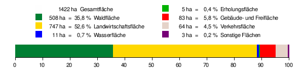
Division of space
According to data from the State Statistical Office , as of 2014.
history
Until the 18th century
Finds show that people were already on the Frickenhofer Höhe in prehistoric times and probably lived there. The finds go back to around 15,000 BC. Free peasants formed a Waibelhube , which had its seat in Ruppertshofen. In documents from the 14th century this association is called "the Waibelhube ob Gemünde" or "the Waibelhube which is located on the forest above Lorch ".
The fact that Ruppertshofen was first mentioned in a sales deed from 1344 was proven to be an error in 2019 by Klaus Graf . A fief book entry about the Waibelhube in 1344 does not yet name the place name, only a further fief book entry around 1369. The originals of both are no longer available, as the Württemberg fief book A was destroyed in the Second World War. The oldest surviving original document dates from 1380.
A particular stroke of fate struck Ruppertshofen in the spring of 1609, when 30 houses fell victim to a fire due to inattention. The chapel dedicated to St. Nicholas also burned down. But it was rebuilt as early as 1610. 212 people died of the plague in 1635. A census in 1785 brought the following result: Ruppertshofen has 68 Limpurgian and 60 Württemberg residents, today's Tonolzbronn district has 43 Limpurgian, 23 Württemberg and 1 Lorchian residents, and today's Hönig district has 36 Limpurgian residents.
On the occasion of the 675 year anniversary of Ruppertshofen (October 18 to 20, 2019), Klaus Graf gave a lecture on the history of Ruppertshofen on October 18, 2019, in which he particularly looked at the time before the 18th century.
19th and 20th centuries
The history of Ruppertshofen is marked by frequent changes of ownership between monasteries, the bars of Limpurg and the aristocratic family of the Württemberg people . The Reichskreis affiliation was also different: Limpurg belonged to the Franconian Empire , while Württemberg was part of the Swabian Empire . In 1806 the limpurgic part of Ruppertshofen finally comes to the Kingdom of Württemberg and belongs to the Oberamt Gmünd as a mayor's shop and in 1809 is assigned to the Oberamt Gaildorf . In 1938 it was incorporated into the Gmünd district . This goes up in 1973 in the Ostalb district, see also Baden-Württemberg district reform 1973 .
Population development
| year | 1790 | 1839 | 1852 | 1871 | 1900 | 1925 | 1950 | 1975 | 1990 | 1995 | 2000 | 2005 | 2010 | 2012 | 2014 | 2016 | 2018 | 2019 |
|---|---|---|---|---|---|---|---|---|---|---|---|---|---|---|---|---|---|---|
| Residents | 700 | 1117 | 1173 | 1121 | 1143 | 1045 | 1351 | 1290 | 1412 | 1689 | 1871 | 1871 | 1833 | 1814 | 1814 | 1816 | 1845 | 1861 |
Assignments
On January 1, 1977, in the course of a voluntary change of area, the districts of Hinterlintal, Hegenreute and Eigenhof were changed to Spraitbach and Hafental to Alfdorf .
Religions
For a long time the church conditions in Ruppertshofen were unusual and complicated. At first Ruppertshofen was assigned to Täferrot . Around 1579 the place was assigned to the parish of Frickenhofen . When the church in Frickenhofen burned down during the Thirty Years' War , the parish of Täferrot (1634–1650) was again responsible. In the following years both were responsible for Ruppertshofen. In 1835 Ruppertshofen was parceled out by Täferrot and completely connected with Frickenhofen. It was not until 1892 that the consistory approved the conversion into a permanent parish . Only a few Catholics lived in Ruppertshofen at that time. There is seldom anything about them in the church registers. In the book by Hermann Kissling you can read about it: “In 1909 parish administrator Friedrich Löwe wrote in a report: 'Our relationship with the Catholic Church, which has parish offices in the neighboring towns of Spraitbach and Zimmerbach, is good, that is, we ignore them and they ignore us . '"
In addition to the Protestant church, there is now a New Apostolic church in town.
politics
Municipal council
The municipality council of Ruppertshofen consists of twelve elected citizens of the municipality and the separately elected mayor as chairman. The local elections on May 26, 2019 led to the following result with a turnout of 61.2%:
- Citizen-friendly list: 6 seats, share of votes 48.3%
- New list: 6 seats, 51.7% of the votes
mayor
Until 1919 the mayor was called Schultheißen, then mayor.
|
|
Administrative affiliation
From 1806 to 1809 Ruppertshofen was part of the Gmünd Oberamt as a mayor's shop . In the course of an administrative reform, Ruppertshofen was assigned to the Oberamt Gaildorf in 1809 . In 1938 the Oberamt Gaildorf was dissolved and Ruppertshofen came to the district of Schwäbisch Gmünd. Due to the district reform in 1973 , the district in the Ostalbkreis was on.
Administrative association
The community is since 1971 member of the local government association Swabian Forest based in Mutlangen .
coat of arms
Blazon : in blue an eight-spoke silver plow wheel, above it a silver scythe leaf lying to the left .
The plow wheel and scythe blade refer to agriculture as well as to the formerly free farmers of Ruppertshofen as well as to the participation of the local population in the Peasants' War in 1525. Blue and silver are the coat of arms colors of the local history taverns of Limpurg .
The municipality flag is white and blue.
In 1930 an unheraldic stamp image of the mayor's office seal showed the initial "R" and two small houses, which were apparently intended to refer to the name component "-hofen". Later official seals also showed the houses in a shield-shaped border, but this image motif was not developed into an officially valid coat of arms.
On March 28, 1958, the Baden-Württemberg Ministry of the Interior awarded the municipality the coat of arms and flag that are valid today.
Partnerships
Since 1992 there has been a community partnership with the former community of Gehringswalde in Saxony, since January 1, 1999 part of the city of Wolkenstein (Ore Mountains) , which continues this partnership.
Attractions

Nikolaus Chapel in Ruppertshofen

Stephanus Church, Tonolzbronn


Nikolaus Chapel (Käppele)
The Nikolaus Chapel, dedicated to St. Nicholas , is located in the center of Ruppertshofen. Its hillside location is secured by low, massive support pillars. The popular name “Käppele” can be derived from this location. The chapel is first mentioned in 1480 and 1507. This means that the construction of the chapel can be dated to the late Middle Ages (before 1500).
Stephen Church
The oldest part is the tower and was probably built in the middle of the 14th century. A wooden structure was attached to it as a long house. The church received its present form around 1500. The church, originally built in the Romanesque style , was rebuilt in the late Gothic style . Between 1997 and 2003 the church was extensively renovated.
Natural monuments

The Götzenloch - often referred to as a hollow stone on maps - is an erosion cave . This lies in a side blade of the Götzenbachtal about 2.5 km east of Ruppertshofen. It is a small cave in the soft sandstones of the upper Stubensandstein. The cave was created by the fact that softer sandstones were eroded under a harder sandstone bank and the cave niche was formed. At the end of the cave, which is now around 4 m deep, a small spring rises, which is responsible for the creation of the cave. The Götzenloch is just a few steps away from the green path cycle path "Around the Leintal and Frickenhofer Höhe" which leads from Ruppertshofen to the Götzenbach reservoir . It is one of the oldest protected natural monuments in the district.
Sports
The Green Path cycle path - around the Leintal and Frickenhofer Höhe - has existed since 2004 . It can be divided into a total of six circuits, which are selected in such a way that intermediate stops can be made again and again. Around 50 information boards are set up along the green path. The central starting point is in Ruppertshofen at the Ostalb vocational training center or at the sports field.
The 147 km long “ Idyllische Straße ” cycle path leads from Eschach via Tonolzbronn, Hönig and Birkenlohe through the municipality.
The Saurier Park archery course is located at Jakobsberg. The archery course has 50 archery targets, divided into four zones of Katzenwald, Krokodilbach, Saurier-Park and Bärenberg, each with ten archery targets. Another ten bow targets are distributed with green plaques at the bow stations.
Regular events
Käppeleslauf, every first Sunday in April. After a two-year break, the eleventh Käppeleslauf took place in 2011. The start is based on age groups and different route lengths. The longest run is 10 km.
Economy and Infrastructure
Ruppertshofen is a typical residential community. There are almost 200 jobs locally, and 600 employees earn their living outside the community.
Resident companies
In March 2007, Pahling Kabelkonfektion GmbH , Ruppertshofen was awarded the ELR project of the month by the Ministry of Food and Rural Areas of Baden-Württemberg as part of the Rural Areas Development Program (ELR).
education
There is a primary school in Ruppertshofen , the closest secondary school (with Werkrealschule ) is in Mutlangen, secondary schools are in Leinzell and Mutlangen. Secondary schools are located in Schwäbisch Gmünd.
Ruppertshofen is the seat of the Ostalb vocational preparation center of Jugendhilfe Ruppertshofen e. V. That concentrates on accompanying and supporting young people on their way to independence and professional life. In October 2010 it celebrated its 60th anniversary.
Personalities
- Jonathan Zenneck (1871–1959), born in Ruppertshofen, physicist, co-inventor of the cathode ray tube and pioneer of German radio technology. The primary school in Ruppertshofen bears his name. In 1952 he received the honorary citizenship of the community.
- Doris Jannausch (1925–2017), German writer, theater actress and cabaret artist, lived in Ruppertshofen-Birkenlohe.
literature
- Albert Deibele : On the history of Ruppertshofen . In: 100 Years of the Ruppertshofen Male Choir eV 1864–1964. Schwäbisch Gmünd 1964 ( Internet Archive ). Manuscript ibid .
- Aloys Schymura: Ruppertshofen through the ages . Ruppertshofen 1995
Web links
Individual evidence
- ↑ State Statistical Office Baden-Württemberg - Population by nationality and gender on December 31, 2018 (CSV file) ( help on this ).
- ^ Daniela Berroth: Age-related dialect use, change and continuity in a Central Swabian dialect , Franz Steiner Verlag, Stuttgart, 2001.
- ^ Housing directory Ostalbkreis , District Office Ostalbkreis, Aalen, 2002.
- ^ The state of Baden-Württemberg. Official description by district and municipality. Volume IV: Stuttgart district, Franconian and East Württemberg regional associations. Kohlhammer, Stuttgart 1980, ISBN 3-17-005708-1 . Pp. 757-759.
- ↑ Mentioned as a desert near Hinterlintal with the date on leo-bw.de .
- ↑ 1446 mentioned: https://digi.ub.uni-heidelberg.de/diglit/nitsch1966bd1/0226 . Lutz Reichardt: Place name book of the Ostalb district. Part I: AL. Stuttgart 1999, ISBN 3-17-015351-X , p. 222 has no direct source evidence, although he proves the document from 1446 and even a document "Getzenlehen" 1464 in the article Hönig p. 307.
- ↑ https://archivalia.hypotheses.org/101082 .
- ^ Lutz Reichardt: Place name book of the Ostalb district. Part II: M-Z. Stuttgart 1999, ISBN 3-17-015352-8 , p. 305 without the reference "Wolperßoffen" in the Augustinian copy book around 1488 Wikimedia Commons .
- ↑ State Statistical Office, area since 1988 according to actual use for Ruppertshofen.
- ↑ https://archivalia.hypotheses.org/97501 .
- ↑ digital copy : http://www.landesarchiv-bw.de/plink/?f=2-2553394-1 .
- ↑ a b c d e f g h i j Aloys Schymura: Ruppertshofen through the ages . Ruppertshofen municipality, 1995.
- ↑ a b c d e Hermann Kissling : The church in Tonolzbronn and the chapel in Ruppertshofen / Ostalbkreis , Evangelical Church Ruppertshofen, 1988 ( online Heidelberg University Library ).
- ↑ Lecture by Klaus Graf “Ruppertshofen and the Waibelhube in History” , accessed on November 24, 2019
- ↑ Baden-Württemberg State Statistical Office.
- ^ Community of Ruppertshofen - Public announcement of the result of the election of the local council on May 26, 2019
- ↑ Heinz Bardua: The communal coat of arms of the Ostalb district . Ostalb-Einhorn 10 (1983), pages 75-88.
- ↑ Heinz Bardua: District and community arms in Baden-Württemberg. Volume 1: The district and community coats of arms in the Stuttgart administrative region . Landesarchivdirektion Baden-Württemberg (ed.), Konrad Theiss Verlag Stuttgart, 1987, 158 pages, ISBN 3-8062-0801-8 .
- ^ Geotopes in the Stuttgart administrative region , State Office for Environmental Protection Baden-Württemberg, Karlsruhe, 2002.
- ^ Geotope cadastre of the state of Baden-Württemberg.
- ↑ " Documentation of the Schwäbisch Gmünd District 1970 " in einhorn 100/101. Jubilee book , Eduard Dietenberger KG, Schwäbisch Gmünd, 1970, p. 272.
- ↑ green path "... around the Leintal and Frickenhofer Höhe" , Ostalbkreis, accessed on March 12, 2008.
- ↑ Idyllische Straße Cycle Route , accessed on April 9, 2012.
- ↑ Saurian Park archery course
- ↑ Jakobsberg Dinosaur Park
- ↑ Press release from the Ministry for Food and Rural Areas Baden-Württemberg , Stuttgart, accessed on March 12, 2008.
- ^ Vocational Preparation Center Ostalb , Ruppertshofen, accessed on March 12, 2008.

Basking | Abtsgmünd | Adelmannsfelden | Bartholomä | Böbingen an der Rems | Bopfingen | Durlangen | Ellenberg | Ellwangen (Jagst) | Eschach | Essingen | Göggingen | Gschwend | Heubach | Hypocrites | Hüttlingen | Iggingen | Jagstzell | Kirchheim am Ries | Lauchheim | Leinzell | Lorch | Mögglingen | Mutlangen | Neresheim | Newbie | Obergröningen | Oberkochen | Rainau | Riesbürg | Rosenberg | Ruppertshofen | Schechingen | Schwäbisch Gmünd | Spraitbach | Stödtlen | Panel red | Tannhausen | Unterschneidheim | Waldstetten | Westhausen | Words