Panel red
| coat of arms | Germany map | |
|---|---|---|

|
Coordinates: 48 ° 51 ' N , 9 ° 50' E |
|
| Basic data | ||
| State : | Baden-Württemberg | |
| Administrative region : | Stuttgart | |
| County : | Ostalbkreis | |
| Height : | 425 m above sea level NHN | |
| Area : | 12 km 2 | |
| Residents: | 1005 (December 31, 2018) | |
| Population density : | 84 inhabitants per km 2 | |
| Postal code : | 73527 | |
| Primaries : | 07175, 07176 | |
| License plate : | AA, GD | |
| Community key : | 08 1 36 070 | |
| Address of the municipal administration: |
Durlanger Strasse 2 73527 Täferrot |
|
| Website : | ||
| Mayor : | Markus Bareis | |
| Location of the municipality of Täferrot in the Ostalb district | ||
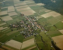
Täferrot is a municipality in Baden-Württemberg and belongs to the Ostalb district .
geography
Geographical location
Täferrot is located in the upper Leintal at the confluence of the Rot in the Lein , between Welzheimer Wald and Frickenhofer Höhe , about 7 km northeast of Schwäbisch Gmünd .
Neighboring communities
The community borders in the north on Ruppertshofen and Eschach , in the east on Göggingen and Leinzell , in the southeast on Iggingen , in the south on the city of Schwäbisch Gmünd and in the west on Durlangen .
Community structure
The community consists of the main town Täferrot, located in the Leintal, the two hilltop hamlets Tierhaupten and Utzstetten as well as the farms Buchhof, Koppenkreut and the Rehnenmühle as well as the abandoned village of Mähderschafhaus.
Division of space

According to data from the State Statistical Office , as of 2014.
history
Until the 19th century
Täferrot was created on cleared ground during the Staufer period. Mentioned in 1293 as Roth , the place was first named Afrenrot in 1298 . At that time the place belonged to the Lords of Weinsberg , later the Lords of Rechberg . In 1357 they sold the patronage rights and the parish property to the Lorch monastery .
In 1560, after the Reformation , the first school was established in the village; it was housed in the town hall. Schoolrooms were also located in the town hall, which was newly built in 1842.
Administrative history
In 1818, Täferrot was one of the few places in Old Württemberg that were assigned to the new Gmünd Oberamt , from 1934 the Schwäbisch Gmünd district . In 1973 the community came to the new Ostalbkreis .
Surname
The place bears its name after the church patron Saint Afra . The place name has developed over time from Afrenrot via Dafrenrot and Tefferrot (1525) to Täferrot .
Religions
When the Reformation was introduced in Württemberg in the 16th century , Täferrot also received the new Evangelical Lutheran denomination. Even today, the St. Afra Church is a member of the Evangelical Regional Church . The few Catholics are looked after from Durlangen and Leinzell .
politics
Administrative association
The community is a member of the Swabian Forest community administration association based in Mutlangen .
Municipal council
The municipal council consists of eight citizens and the mayor.
mayor
With a turnout of 77.4 percent, Markus Bareis was elected as the new mayor in May 2019 with 50.6 percent of the valid votes. Predecessor Daniel Vogt had prevailed in the election of the mayor of Herbrechtingen in March 2019 after four years in office .
coat of arms
The coat of arms shows a stylized St. Afra in the middle of flames on a red background, as she is said to have died by fire. Below that, the confluence of the rivers Rot and Lein is symbolically represented in white in a symmetrical form.
Buildings worth seeing
- Today's Protestant St. Afra Church was built in 1491. The tower is older and comes from a previous church.
- The Täferrot flood retention basin is located on the Lein around one kilometer above the town, in a south-westerly direction. The Rehnenmühle der Rot flood retention basin is located between the Tierhaupten and Durlangen districts .
education
Täferrot has a primary school and a kindergarten .
Web links
Individual evidence
- ↑ State Statistical Office Baden-Württemberg - Population by nationality and gender on December 31, 2018 (CSV file) ( help on this ).
- ^ The state of Baden-Württemberg. Official description by district and municipality. Volume IV: Stuttgart district, Franconian and East Württemberg regional associations. Kohlhammer, Stuttgart 1980, ISBN 3-17-005708-1 . Pp. 726-728.
- ↑ State Statistical Office, area since 1988 according to actual use for Täferrot.
- ↑ a b Diethelm Winter (Ed.): The Ostalbkreis . Theiss, Stuttgart 1992, ISBN 3-8062-0891-3 , pp. 367 f .
- ^ Täferrot ( Memento from July 28, 2010 in the Internet Archive ), Täferrot volunteer fire department.
- ↑ https://www.staatsanzeiger.de/de/staatsanzeiger/wahlen/buergermeisterwahlen/taeferrot/


