
Newbie
| coat of arms | Germany map | |
|---|---|---|

|
Coordinates: 48 ° 56 ' N , 10 ° 4' E |
|
| Basic data | ||
| State : | Baden-Württemberg | |
| Administrative region : | Stuttgart | |
| County : | Ostalbkreis | |
| Height : | 518 m above sea level NHN | |
| Area : | 36.27 km 2 | |
| Residents: | 3177 (Dec. 31, 2018) | |
| Population density : | 88 inhabitants per km 2 | |
| Postcodes : | 73491, 73479 | |
| Primaries : | 07961, 07963 | |
| License plate : | AA, GD | |
| Community key : | 08 1 36 046 | |
| LOCODE : | DE N2R | |
| Address of the municipal administration: |
Hauptstrasse 15 73491 Neuler |
|
| Website : | ||
| Mayoress : | Sabine Heidrich | |
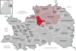
| Location of the municipality of Neuler in the Ostalb district | ||
  |
||

Neuler is a municipality in the Ostalbkreis in Baden-Württemberg .
geography
Geographical location
Neuler is located on a ridge between Kocher and Jagst , about seven kilometers southwest of Ellwangen . It is part of the natural areas of the Eastern Alb foreland and the Swabian-Franconian Forest Mountains , both of which are part of the Swabian Keuper-Lias region .
Neighboring communities
The community borders in the north on Rosenberg , in the northeast on the city of Ellwangen, in the east on Rainau , in the south on Hüttlingen , in the southwest on Abtsgmünd and in the west on Adelmannsfelden .
Community structure
The municipality of Neuler includes the village of Neuler, the hamlets of Bronnen, Ebnat, Gaishardt , Leinenfirst, Ramsenstrut and Schwenningen, the Haldenhof farmstead and the Adlersteige, Binderhof, Burghardsmühle, Burgstall, Himmelreich, Kohlwasen, Pfaffenhölzle and Schönberger Hof villages and the villages of Burgstall, Gladly, Oberbrandhof, Schlierhof, Schliermühle, Schöffelhöfe and Schönenberg.
Division of space

According to data from the State Statistical Office , as of 2014.
history
Local history
Neuler was first mentioned in a document in 1113 . In 1746 the baroque parish church was built on the foundation walls of a Gothic church. The place initially belonged to the prince provost of Ellwangen . When this fell to the Kingdom of Württemberg with the secularization due to the Reichsdeputationshauptschluss in 1803 , Neuler was assigned to the Oberamt Ellwangen . As part of the district reform in 1938, Neuler came to the Aalen district , which was merged into the newly created Ostalb district as a result of the district reform in 1973 . After the Second World War , the formerly agricultural place developed into a workers' community.
Incorporations
On January 1, 1977, the area of the hamlet of Schwenningen, which had almost 200 inhabitants at that time and which had belonged to the neighboring community of Rainau, was incorporated.
Population development
The population figures from 1852 to 1970 are census results and from 1980 official updates of the State Statistical Office (only main residences ).
|
|
Religions

Even after the Reformation was introduced in other parts of Germany, Neuler remained Catholic. Even today, the majority of the residents are parishioners of the Roman Catholic Church of St. Benedict. The few evangelical believers belong to the parish of Ellwangen .
politics
The community is a member of the agreed administrative community of the city of Ellwangen (Jagst) .
mayor
Manfred Fischer was elected mayor for the first time in December 1985 and was re-elected in 1993, 2001 and 2009.
Sabine Heidrich was elected mayor in November 2017.
coat of arms
Blazon : "In red a left-facing silver plow with double wheel and coulter."
Culture and sights
Sports
The most famous sports club in Neuler is the Neuler gymnastics club.
Regular events
Neuler is known for its carnival parade. Every year on Shrove Sunday, numerous people, according to the Neulermer Narren 1906 association up to 25,000, line the streets to watch the carnival parade with the many themed wagons and foot groups.
Economy and Infrastructure
education
In Neuler there is a primary school with the Brühlschule . Secondary schools are located in Ellwangen. There are also two Roman Catholic kindergartens in town.
Personalities
Sons and daughters of the church
- Johann Leonhard Bayrhammer (1828–1881), member of the Reichstag and Landtag, mayor of Ellwangen
- Stephan Jakob Neher (1829–1902), Catholic theologian and church historian
- Helmut Dietterle (* 1951), soccer player (VfB Stuttgart)
Web links
Individual evidence
- ↑ State Statistical Office Baden-Württemberg - Population by nationality and gender on December 31, 2018 (CSV file) ( help on this ).
- ↑ Natural areas of Baden-Württemberg . State Institute for the Environment, Measurements and Nature Conservation Baden-Württemberg, Stuttgart 2009.
- ^ The state of Baden-Württemberg. Official description by district and municipality. Volume IV: Stuttgart district, Franconian and East Württemberg regional associations. Kohlhammer, Stuttgart 1980, ISBN 3-17-005708-1 , pp. 711-713.
- ↑ State Statistical Office, area since 1988 according to actual use for Neuler.
- ↑ http://neuler.de/gemeinde/geschichte.php History of Neulers
- ^ Federal Statistical Office (ed.): Historical municipality directory for the Federal Republic of Germany. Name, border and key number changes in municipalities, counties and administrative districts from May 27, 1970 to December 31, 1982 . W. Kohlhammer, Stuttgart / Mainz 1983, ISBN 3-17-003263-1 , p. 472 .
- ↑ census results on Leo-BW
- ↑ https://www.ostalbkreis.de/sixcms/detail.php?template_id=102&_topnav=68&id=170381&detail_presse=1 ( page no longer available , search in web archives ) Info: The link was automatically marked as defective. Please check the link according to the instructions and then remove this notice.
- ↑ Sabine Heidrich wins mayoral election . In: Swabian . ( schwaebische.de [accessed on April 23, 2018]).

Basking | Abtsgmünd | Adelmannsfelden | Bartholomä | Böbingen an der Rems | Bopfingen | Durlangen | Ellenberg | Ellwangen (Jagst) | Eschach | Essingen | Göggingen | Gschwend | Heubach | Hypocrites | Hüttlingen | Iggingen | Jagstzell | Kirchheim am Ries | Lauchheim | Leinzell | Lorch | Mögglingen | Mutlangen | Neresheim | Newbie | Obergröningen | Oberkochen | Rainau | Riesbürg | Rosenberg | Ruppertshofen | Schechingen | Schwäbisch Gmünd | Spraitbach | Stödtlen | Panel red | Tannhausen | Unterschneidheim | Waldstetten | Westhausen | Words