Schechingen
| coat of arms | Germany map | |
|---|---|---|

|
Coordinates: 48 ° 52 ' N , 9 ° 55' E |
|
| Basic data | ||
| State : | Baden-Württemberg | |
| Administrative region : | Stuttgart | |
| County : | Ostalbkreis | |
| Height : | 478 m above sea level NHN | |
| Area : | 11.87 km 2 | |
| Residents: | 2268 (December 31, 2018) | |
| Population density : | 191 inhabitants per km 2 | |
| Postal code : | 73579 | |
| Area code : | 07175 | |
| License plate : | AA, GD | |
| Community key : | 08 1 36 062 | |
| LOCODE : | DE S3B | |
| Address of the municipal administration: |
Marktplatz 1 73579 Schechingen |
|
| Website : | ||
| Mayor : | Werner Jekel | |
| Location of the community Schechingen in the Ostalb district | ||
Schechingen is a municipality in Baden-Württemberg and belongs to the Ostalb district .
geography
Geographical location
Schechingen is located north of Schwäbisch Gmünd on the Frickenhofer Höhe , a ridge that runs south of the Kocher .
Neighboring communities
The community borders in the north on Obergröningen , in the east on Abtsgmünd , in the south on Heuchlingen , in the southwest on Göggingen and in the northwest on Eschach .
Community structure
The community of Schechingen includes the village of Schechingen, the hamlets of Haghof, Klotzhöfe, Leinweiler and Sebastiansweiler, the farms of Mühlholz and Zeirenhof and the Haldenhaus house as well as the locality of Marbach, which has been abandoned .
Division of space

According to data from the State Statistical Office , as of 2014.
history

From 1435 Schechingen was part of the domain of the Count Adelmann von Adelmannsfelden at Schechingen Castle . Between 1789 and 1790 the place suffered from the cattle disease. In 1860 the Holzhausener Tor and the gate in Kronengasse were demolished, and in 1908 the Schießberger Tor. In 1914 Schechingen was connected to the power grid and in 1919 to the state water supply. 1931 Leinweiler is incorporated. As part of the mediation due to the Reichsdeputationshauptschluss , the place fell in 1806 to the Kingdom of Württemberg , where it came to the Oberamt Aalen , which in 1934 became the Aalen district, which was transferred to the Aalen district in 1938 . However, Schechingen moved to the district of Schwäbisch Gmünd , with which it was opened up by the district reform in 1973 in the new Ostalb district.
Towards the end of the Second World War, enemy low-flying planes bombed the place, causing the Schießberg to catch fire. On April 23, 1945, American soldiers occupied Schechingen. In 1962 the Aussiedlerhof was built in Hirtenfeld. On August 3, 1978, an F3 tornado damaged around 70 houses, some severely. A 50 meter wide and 600 meter long aisle with severe damage ran through Schechingen. There were six slightly injured, but no deaths. In 1993, the Schafwiesen II building area was expanded and the Kesselfeld building area , which was built on from 1994, was developed. The Schlossgarten building areas followed later and, from 2001 to 2002, the Western Schlossgarten . In 2014, the development of the Am Horner Weg building area began . In 2016, the Kappelfeld industrial park was opened up .
Population development
The population figures from 1852 to 1970 are census results and from 1980 official updates of the State Statistical Office (only main residences ).
|
|
Religions
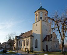
The Reformation passed Schechingen by, so the place remained Catholic. Even today there is only the Roman Catholic Church of St. Sebastian in the village. The few evangelical believers belong to the parish of Obergröningen .
politics
Administrative association
The community is a member of the Leintal-Frickenhofer Höhe community administration association based in Leinzell .
mayor
- until 1965: Josef Schäffner
- 1966–1996: Jürgen Schaich
- since 1996: Werner Jekel, his current term of office ends in 2020
Municipal council
The municipal council consists of 10 citizens who were last elected by majority vote on May 25, 2014.
Economy and Infrastructure
Schechingen is a typical residential community. There are around 220 jobs locally, and almost 900 workers earn their living outside the community.
education
In Schechingen there is only one primary school , the secondary school of the municipal administration association and a secondary school are located in Leinzell. Secondary schools are available in Schwäbisch Gmünd. There is a communal and a Roman Catholic kindergarten for the youngest Schechingers .
Attractions
Easter fountain
An Easter fountain is built in Schechingen every Easter time. It is now the largest Easter fountain in East Württemberg. With its approx. 11,000 hand-painted eggs, it attracts thousands of visitors every year (approx. 50,000 visitors in 2014) to the small town.
outdoor pool
Where the Schechingen open-air swimming pool stands today, there was once a pond, the so-called Schlossgartenweiher. It served as a lake of fire and was used as a trough for the cattle in dry years. In April 1945, shortly before the end of the war, people threw weapons and ammunition into the lake for fear of the approaching Americans. In 1955, the community received the requirement to clean the lake of fire. At that time, the school suggested to Mayor Schäffner to renew the lake so that one could swim in it at the same time. The state only gave grants if the bath had a certain size. So the local council decided to build today's swimming pool. Construction began in 1962. In July 1964 you could bathe for the first time, but at your own risk. The Schechingen open-air swimming pool was completely rebuilt between 1984 and 1986 and brought up to the latest technology. In 2000, the old sanitary building was demolished and a new building with a sanitary room was built that meets today's hygiene requirements.
Personalities
Sons and daughters of the church
- Bernhard Adelmann von Adelmannsfelden (1457 or 1459–1523), humanist
- Joseph Vogt (1895–1986), ancient historian
- Thomas Tauporn (* 1991), sport climber
literature
Web links
Individual evidence
- ↑ State Statistical Office Baden-Württemberg - Population by nationality and gender on December 31, 2018 (CSV file) ( help on this ).
- ^ The state of Baden-Württemberg. Official description by district and municipality. Volume IV: Stuttgart district, Franconian and East Württemberg regional associations. Kohlhammer, Stuttgart 1980, ISBN 3-17-005708-1 , pp. 746-748.
- ↑ State Statistical Office, area since 1988 according to actual use for Schechingen.
- ↑ http://www.schechingen.de/info/geschichte/ History of Schechingen
- ↑ census results on Leo-BW


