
Kirchheim am Ries
| coat of arms | Germany map | |
|---|---|---|

|
Coordinates: 48 ° 53 ' N , 10 ° 24' E |
|
| Basic data | ||
| State : | Baden-Württemberg | |
| Administrative region : | Stuttgart | |
| County : | Ostalbkreis | |
| Height : | 485 m above sea level NHN | |
| Area : | 21.05 km 2 | |
| Residents: | 1820 (Dec. 31, 2018) | |
| Population density : | 86 inhabitants per km 2 | |
| Postcodes : | 73467, 73441 | |
| Area code : | 07362 | |
| License plate : | AA, GD | |
| Community key : | 08 1 36 037 | |
| Address of the municipal administration: |
On the Wört 7 73467 Kirchheim am Ries |
|
| Website : | ||
| Mayor : | Willi Feige | |
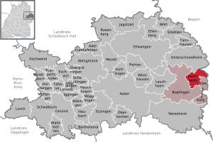
| Location of the municipality of Kirchheim am Ries in the Ostalb district | ||
  |
||

Kirchheim am Ries is a municipality in Baden-Württemberg and belongs to the Ostalb district .
geography
Geographical location
Kirchheim am Ries is located on the edge of the eastern Swabian Alb , on the western edge of the Nördlinger Ries in the Ries Geopark , at the foot of the Blasienberg.
Neighboring communities
The community borders in the north on Unterschneidheim , in the east on Wallerstein in the Bavarian district of Donau-Ries , in the southeast on Riesbürg and in the south and west on the city of Bopfingen .
Community structure
The municipality of Kirchheim am Ries with the formerly independent municipalities Benzenzimmern and Dirgenheim includes nine villages, hamlets and farms. The village of Benzenzimmern belongs to the former community of Benzenzimmern. The village of Dirgenheim and the homestead Kreuthof as well as the abandoned villages of Stolzenberg and the "castle of the local aristocracy", which was probably within Dirgenheim, belong to the former municipality of Dirgenheim . The village of Kirchheim am Ries, the hamlets of Jagstheim and Osterholz and the farms of Heerhof, Kalkofen and Weihermühle as well as the abandoned villages of Goldbach and Ziegelhütte belong to the municipality of Kirchheim am Ries in the territorial status of December 31, 1971.
Division of space

According to data from the State Statistical Office , as of 2014.
history

Early history
On the western edge of the village is an Alemannic burial ground. According to the excavation results from 1962 to 1964, it consists of a large main and a smaller side cemetery as well as a clearly separated aristocratic burial site. 518 graves with at least 570 burials were found. While the dead were usually buried in simple earth graves on the main burial ground, large wooden chambers were also found in the aristocratic cemetery. The cemetery was occupied from the middle of the 6th to the 8th century. The separate cemetery was established towards the end of the 7th century, although the majority of these originally magnificent graves were robbed early on.
middle Ages
Count Ludwig von Öttingen founded the Assumption Monastery in 1267 .
Modern times
In 1552 the Protestant Count Ludwig von Öttingen-Öttingen enforced in the Passau Treaty that the village of Kirchheim became Protestant, whereas the monastery was allowed to remain Catholic. In 1731 the Catholic Count Josef Anton Karl von Öttingen-Wallerstein took over the bailiwick, so that the monastery was able to convert most of the villagers back to Catholicism in the following period.
In 1802 the monastery and village fell under the rule of the underage Prince Ludwig von Öttingen-Wallerstein in the course of secularization . In 1805 the monastery was closed. In 1806 Kirchheim came to the Kingdom of Bavaria and in 1810 to the Kingdom of Württemberg . Kirchheim was subordinated to the Württemberg Oberamt Neresheim . During the district reform in Württemberg during the Nazi era , Kirchheim came to the Aalen district in 1938 . In 1945 the place came into the American zone of occupation and thus belonged to the newly founded state of Württemberg-Baden , which was incorporated into the current state of Baden-Württemberg in 1952. In 1973 the district reform took place in Baden-Württemberg , when Kirchheim became part of the Ostalb district.
Incorporations
![]() On January 1, 1972, the previously independent community of Benzenzimmern was incorporated.
On January 1, 1972, the previously independent community of Benzenzimmern was incorporated.
![]() On January 1, 1973, the previously independent municipality of Dirgenheim was added.
On January 1, 1973, the previously independent municipality of Dirgenheim was added.
politics
mayor
In December 2013, Willi Feige was re-elected for a third term.
Municipal council
After the 2014 election, the municipal council has 14 members.
Administrative community
The community is a member of the agreed administrative community of the city of Bopfingen .
Partnerships
Kirchheim am Ries maintains partnership relationships with the municipality of Solarolo in Emilia-Romagna in Italy .
Culture and sights

theatre
- Every three years the Passion Play takes place in the Dirgenheim district in St. George's Church. The next games are scheduled for March and April 2022.
Buildings
- Chapel of St. Martin
- An upside-down Roman sacrificial stone serves as an altar.
- Cistercian convent of the Assumption of Mary in Kirchheim am Ries
- Jagstheim pilgrimage chapel
Economy and Infrastructure
traffic
The state road L 1060, which runs from the Bavarian border to Ellwangen , runs through the two towns of Dirgenheim and Benzenzimmern .
Personalities
Sons and daughters of the church
- Viktor von Sandberger (born April 10, 1835 in the Benzenzimmern district; † May 12, 1912 in Stuttgart), theologian, president of the consistory of the Evangelical Church in Württemberg
- Dietrich Bundschuh (born January 26, 1930 in Kirchheim am Ries), lawyer, judge at the Federal Court of Justice
literature
- U. Knapp: Monastery church Mariae Himmelfahrt in Kirchheim, Ries. Observations on building history. Rieser Kulturtage 10, 1995, 430–477
- Ch. Neuffer-Müller: The Alemannic aristocratic burial ground and the row graveyards of Kirchheim am Ries. Research u. Ber. Before u. Mornings Bad-Württ. 15 (Stuttgart 1983)
Web links
Individual evidence
- ↑ State Statistical Office Baden-Württemberg - Population by nationality and gender on December 31, 2018 (CSV file) ( help on this ).
- ^ The state of Baden-Württemberg. Official description by district and municipality. Volume IV: Stuttgart district, Franconian and East Württemberg regional associations. Kohlhammer, Stuttgart 1980, ISBN 3-17-005708-1 . Pp. 691-694
- ↑ State Statistical Office, area since 1988 according to actual use for Kirchheim am Ries.
- ↑ a b Federal Statistical Office (ed.): Historical municipality register for the Federal Republic of Germany. Name, border and key number changes in municipalities, counties and administrative districts from May 27, 1970 to December 31, 1982 . W. Kohlhammer, Stuttgart / Mainz 1983, ISBN 3-17-003263-1 , p. 445 .
- ↑ https://www.staatsanzeiger.de/staatsanzeiger/wahlen/buergermeisterwahlen/kirchheim-am-ries/
- ↑ http://www.kirchheim-am-ries.de/index.php?id=69

Basking | Abtsgmünd | Adelmannsfelden | Bartholomä | Böbingen an der Rems | Bopfingen | Durlangen | Ellenberg | Ellwangen (Jagst) | Eschach | Essingen | Göggingen | Gschwend | Heubach | Hypocrites | Hüttlingen | Iggingen | Jagstzell | Kirchheim am Ries | Lauchheim | Leinzell | Lorch | Mögglingen | Mutlangen | Neresheim | Newbie | Obergröningen | Oberkochen | Rainau | Riesbürg | Rosenberg | Ruppertshofen | Schechingen | Schwäbisch Gmünd | Spraitbach | Stödtlen | Panel red | Tannhausen | Unterschneidheim | Waldstetten | Westhausen | Words