Hönig (Ruppertshofen)
|
Honey
Ruppertshofen municipality
Coordinates: 48 ° 53 '30 " N , 9 ° 47' 55" E
|
|
|---|---|
| Height : | 435 (429-445) m |
| Area : | 2.78 km² |
| Residents : | 177 |
| Population density : | 64 inhabitants / km² |
| Postal code : | 73577 |
| Area code : | 07176 |
Hönig (until the 19th century also Höneck ) is a suburb of the municipality of Ruppertshofen in the Ostalbkreis in eastern Baden-Württemberg .
geography
location
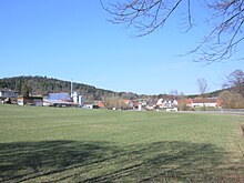
Hönig is located in the broad Auental valley of the Gschwender Rot , which flows to the south-east and which is just below the village at 429 m above sea level. NN from the left and northeast of the Auerbach flows , whereupon it continues south and separates the Frickenhofer Höhe in the east with the municipality capital Ruppertshofen ( 511 m above sea level ) in the east from the next Liasplatte of the Welzheimer forest in the west around Spraitbach .
The greater part of the village lies in the angle of the mouth on the flat valley floor or at the lower foot of the slope of the mouth spur at a maximum of 445 m above sea level. NN . The smaller one with the Hönigmühle and a few other buildings stands between a left Mühlkanal of the inflowing Rot and this itself or even to the right of this also at the foot of the slope. Hönig is about 1½ km to the north-west from the main town of Ruppertshofen, Gschwend is about 6 km to the north-west, Spraitbach is less than 3 km to the west- south- west (as the crow flies).
The Bittelhof, Boschenhof, Fuchsreute, Krebenhaus, Lettenhäusle and Ulrichsmühle residential areas belong to the Hönig district.
history
After the first colonization of Ruppertshofen , Ilgertshofen, Tonolzbronn , Steinenbach and Hönig by the king's servants, a servant with royal permission built the Hönigmühle around 1100 AD. Over the centuries, the Hönigmühle changed hands several times and was called Ulrichsmühle from 1696, when Ulrich Barth took over the Hönigmühle. The importance of the mill as a grinding and sawmill grew when about 100 years later the farmers of the Weibelhube who were not cleared of clearing, set up their farms. The Hönigmühle was initially a fief of the Limpurg taverns . In the morning hours of May 5, 1812, the original Ulrichsmühle burned down completely, and the family perished in the flames.
The individual property rights in the place changed frequently. The taverns of Limpurg, the Lorch monastery , the imperial city of Schwäbisch Gmünd, the Dominican convent of Gotteszell and the gentlemen of Rechberg-Heuchlingen owned and had rights in Hönig.
In 1360 Heinrich von Rechberg-Heuchlingen sold together with the Kirchsatz in Spraitbach and Zimmerbach his large and small tithe in Hönig to the Gotteszell monastery.
The chaplain Maria Magdalena in the Holy Cross Church in Schwäbisch Gmünd bought an estate in Hönig in 1418.
In 1552 the two goods belonging to the Weibelhube were divided into seven goods. In 1556 Limpurg bought two goods from the imperial city of Schwäbisch Gmünd and in 1557 their remaining rights in the place. The Limpurg taverns acquired two further goods from Ulrich von Rechberg in 1567 . Bittelhof and the Ulrichsmühle belonged to Gotteszell Monastery. The Lords of Limpurg-Gaildorf owned a part of the small tithe, another part belonged to the parish Spraitbach, which also had the rights to all tithe of the Boschenhof.
In 1785 Limpurg had 36 subjects in town. In 1807 78 residents belonged to the Weibelhube, 12 to the Lorch monastery and 6 to Gmünd.
After Württemberg took control of this area, Hönig and the surrounding farmsteads were initially assigned to the Gmünd Oberamt , but on April 26, 1808, they were spun off and incorporated into the Gaildorf Oberamt . The upper official limit ran at Lettenhäusle and Boschenhof. In terms of church law, however, Hönig remained a branch of the Spraitbach parish in the Oberamt Gmünd with Boschenhof, Steinenbach and Hönigmühle.
In 1844 the construction of the road from Ruppertshofen to Spraitbach began. The course was laid by Hönig, whereby the small town was connected to a paved road for the first time.
In the middle of the 19th century there were 193 residents in Hönig and Krebenhaus. There were also 19 residents of the Bittelhof, 15 of the Ulrichsmühle, 14 in Lettenhäusle and 7 residents of the Fuchsreute. The majority of the inhabitants were Protestants, only 17 Catholics were counted in Lettenhäusle and Fuchsreute, which at that time were still considered independent residential areas of Ruppertshofen.
With the district reform in 1938, Hönig came to the Schwäbisch Gmünd district .
Towards the end of the Second World War , a telephone department of the Wehrmacht was briefly stationed in Hönig . From the beginning of April 1945, the small town was more often the target of low-level aircraft attacks, which the population called "cow hunts". On April 19, 1945, the Volkssturm was convened in Hönig , but the call was no longer obeyed. On the same day, US troops appeared at the entrance to the town. The French prisoners of war in Hönig vouched for the inhabitants, so that the place was occupied without a fight. When the machines and vehicles left behind at the construction site of the planned runway near Steinenbach were blown up on April 20, 1945, some power poles were unintentionally destroyed. As a result, the Hönig pumping station failed. Ruppertshofen and the surrounding area then remained without a water supply for several weeks.
In 1980 the municipality of Ruppertshofen successfully fought against a retention basin planned by the Kocher-Lein water association in the Auerbachtal.
Economy and Infrastructure
A sawmill, a timber processing company and two wood processing companies have settled here at larger companies.
traffic
Coming from Gschwend in the northwest, the district road K 3253 runs through Hönig via Ruppertshofen to Leinzell . From here the K 3254 branches off to Spraitbach , where it reaches the B 298 . Lower-ranking streets lead to scattered courtyards in the area.
A FahrBus Gmünd line connects the place with Schwäbisch Gmünd and Gaildorf .
Culture and sights
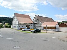
The residents of Hönig joined forces in 1989 to form the Hönig village community . Together they run the Hönig village house, which is open Wednesday, Saturday and Sunday. The former stable was converted into today's village house by the village community in voluntary hours and officially inaugurated on February 10, 1995.
Hönig is a stage on the 147 km long “ Idyllische Straße ” cycle path .
A round tour of the Green Path cycle path also leads through Hönig - around the Leintal and Frickenhofer Höhe . It can be divided into a total of six circuits, which are selected in such a way that intermediate stops can be made again and again. Around 50 information boards are set up along the green path. The central starting point is in Ruppertshofen at the Ostalb vocational training center or at the sports field.
A hiking trail of the Swabian Alb Association leads along the Rot through the town towards Schwäbisch Gmünd.
swell
- ↑ a b c “ Description of the Oberamt Gaildorf . Issued by the Royal Bureau of Statistics and Topography. With three tables and a map of the Oberamt, along with a cover picture and a woodcut. “, JB Müller's Verlagshandlung, Stuttgart, 1852.
- ↑ Geoportal Baden-Württemberg ( information )
- ^ Daniela Berroth: Age-related dialect use, change and continuity in a Central Swabian dialect , Franz Steiner Verlag, Stuttgart, 2001.
- ↑ Aloys Schymura: Ruppertshofen through the ages . Ruppertshofen municipality, 1995.
- ↑ Karl Eduard Paulus, Eduard Paulus, Hermann Bauer: Description of the Oberamt Gmünd . Stuttgart: H. Lindemann, 1870, page 323f.
- ↑ Albert Deibele : " The end of the war in 1945 in the Schwäbisch Gmünd district ", Schwäbisch Gmünd, 1966.
- ↑ Chronicle of the Ostalbkreis in Ostalb Einhorn. Quarterly booklets for home and culture in the Ostalbkreis , No. 25, Schwäbisch Gmünd, 1980, p. 80.
- ↑ Hans-Wolfgang Bächle : " Culture and history in the Gmünder area ", Remsdruckerei Sigg, Härtel & Co., Schwäbisch Gmünd, 1982, p. 302.
- ↑ " Brochures, T-Shirts and Engagement. Even in its 20th year of existence, the Höniger village community is a sworn troop ”in Gmünder Tagespost from July 15, 2008.
- ↑ “ A close cohesion ” in Gmünder Tagespost of July 12, 2007.
- ↑ Idyllische Straße Cycle Route , accessed on April 9, 2012.
- ↑ green path "... around the Leintal and Frickenhofer Höhe" , Ostalbkreis, accessed on March 12, 2008.

