Tonolzbronn
|
Tonolzbronn
Ruppertshofen municipality
Coordinates: 48 ° 53 ′ 21 ″ N , 9 ° 49 ′ 27 ″ E
|
|
|---|---|
| Height : | 529 m above sea level NN |
| Area : | 3.32 km² |
| Postal code : | 73577 |
| Area code : | 07176 |
|
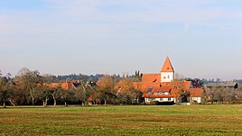
Tonolzbronn, looking north
|
|
Tonolzbronn is a suburb of the municipality of Ruppertshofen in the Ostalbkreis in eastern Baden-Württemberg and is located around one kilometer northeast of the main municipality.
The place name Tonolzbronn is based on a location. Bronnen = source of the Haldenbach - a source brook of the Brühlbach, which flows into the Rot near Hönig . Tonolz, presumably an indication of the location of a settlement in a wooded area. Previously common spellings of Tonolzbronn were Tunoltzbronn, Tunensprunn, Tuonspronn, Tunsprunn, Thunolzbrunn, Tonnesbronn, Thünoltzbronn, Donasprun, Tonaspronn, Donnolzbronn, Donolzbronn, Danasbrun, Thonolzbronn, Donasprung.
geography
Landscape image
On the flat plateau around Tonolzbronn agriculture dominates with fields and meadows. There is forest on the slopes of the Brühlbach valley, which flows into the Auerbaches .
history
The beginnings of Tonolzbronn - like those of the main town Ruppertshofen - extend into the 9th / 10th. Century back. Up to the 12th century the development of the two places should have been the same. Only then did Ruppertshofen receive a sustainable development boost and grew from a hamlet to a village. The trigger for this was the reorganization of the Hohenstaufen estate, which Friedrich I of Staufen initiated and grandson Friedrich I (Barbarossa) continued.
A special feature of the community of Ruppertshofen is that the church is not in the main town, but in the suburb of Tonolzbronn. The church, built around 1500, is dedicated to St. Stephen. The Nikolaus Chapel is located in Ruppertshofen itself .
The lost place Wolfertshofen was between Tonolzbronn and Ruppertshofen.
At the end of 1944, at the end of the Second World War , the Nazi construction team Organization Todt set up a large construction site on the level between Seifertshofen , Steinenbach , Helpertshofen and Kemnaten , with the aim of building a 2.5 km long concrete runway for jet fighters of the Messerschmitt Me 262 type to build. Around 600 workers, mostly prisoners of war , were deployed, barracks were built in the surrounding villages and wooded areas were cut down. Due to the advance of the US Army, construction work was canceled on April 18, 1945.
Economy and Infrastructure
The suburb is purely agricultural.
traffic
The distance to the main town is about 1 km. Tonolzbronn is on the K 3328, which leads from the south ( Täferrot , Ruppertshofen) to the north, where it reaches the L 1080 after the Ziegelhütte. A FahrBus Ostalb line connects the town with Schwäbisch Gmünd and Gaildorf .
Web links
Individual evidence
- ^ Hermann Kissling: The church in Tonolzbronn and the chapel in Ruppertshofen . Evangelical parish Ruppertshofen, Deanery Schwäbisch Gmünd, Ruppertshofen 1988, p. 71 ( uni-heidelberg.de ).
- ^ Hermann Kissling: The church in Tonolzbronn and the chapel in Ruppertshofen . Evangelical parish Ruppertshofen, Deanery Schwäbisch Gmünd, Ruppertshofen 1988, p. 5 ff .
- ^ Hermann Kissling: The church in Tonolzbronn and the chapel in Ruppertshofen . Evangelical parish Ruppertshofen, Deanery Schwäbisch Gmünd, Ruppertshofen 1988, p. 63 ff .
- ↑ “ Description of the Oberamt Gaildorf. Issued by the Royal Bureau of Statistics and Topography. With three tables and a map of the Oberamt, along with a cover picture and a woodcut. “, JB Müller's Verlagshandlung, Stuttgart, 1852.
- ^ Walter Hees: The Americans are coming ... Verlag Manfred Hennecke, Remshalden 2006, ISBN 3-927981-84-2 , p. 133 ff .

