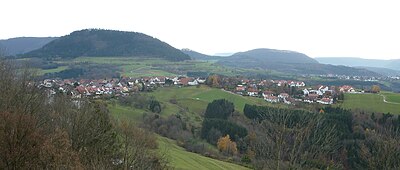
Foreland of the eastern Swabian Alb
The foreland of the eastern Swabian Alb , also known as the Eastern Alb foreland , is a natural area (main unit 102) of the Swabian Keuper-Lias-Land in the south-west of Germany .
location
The Eastern Alb foreland covers approximately 751 km², it extends around 66 kilometers along the Alb eaves . To the north it borders on the natural areas 107 Schurwald and Welzheimer Wald and 108 Swabian-Franconian Forest Mountains . To the south the area borders on the natural area 96 Albuch and Härtsfeld . The most important cities in the east-west direction are Göppingen , Schwäbisch Gmünd , Aalen and Bopfingen . It is broken down as follows:
- 102.0 Albuch foreland
- 102.00 Roe foothills
- 102.01 Rehgebirge
- 102.02 Lias plates over Rems and Lein
- 102.03 Frickenhofer Höhe
- 102.04 Welland
- 102.1 Härtsfeldvorland
- 102.10 Plate by Neuler
- 102.11 Goldshöfer terrace slabs
- 102.12 Pfahlheim-Rattstädter Lias plates
- 102.13 Hills of Baldern
- 102.14 Western giant forecourts
geology
The Eastern Alb foreland is a poorly modeled landscape with shallow valleys. The main features are the mighty elevations of the Braunjura hill country with the Rehgebirge , Welland and the hill country of Baldern with a height of up to 750 m above sea level. NN. In between there are large lias surfaces . In the Härtsfeldvorland, the lias plates accompany the Braunjura hill country of Baldern as an evenly broadly developed strip. Middle and upper lias are more common in the Eastern Alb foreland. Lias and Keuperland are more closely interlocked than in the Middle Alb foreland. The eastern part drains over the Wörnitz to the Danube , the western area is drained by Jagst , Kocher and Rems over the Neckar to the Rhine . The soils of the Lias plates are very fertile and are therefore also known as so-called arable plates. Therefore arable farming predominates in the area. The open country character is dominated by fields and pastures and is only replaced by a forest landscape on the mountain ranges. Grassland farming is practiced in the more humid depressions. Due to the high proportion of arable and green areas, the focus of the nature conservation significance of the landscape is here. However, there is also the risk of monostructure and species impoverishment.
climate
Compared to the thermally somewhat more favorable Middle Alb foreland , the east is set off by around 1 degree lower temperatures and thus comes closer to the Keuper forest areas to the north. In the Keuperbergland the precipitation drops to 850–900 mm; the Eastern Alb foreland is consequently only slightly more rainy than the Middle Alb foreland.
Protected areas
Due to their high agricultural importance, only a few areas are designated as nature reserves or FFH areas. In particular in the Rehgebirge and on the Albtrauf there are still sloping forests in need of protection. In addition, there are numerous torrent and stream biotopes, some of which are near-natural. In the southwest there are several larger and contiguous protected landscape areas.
| Protected area shares | % Total landscape area |
|---|---|
| FFH areas | 4.91 |
| European bird sanctuaries | 0.03 |
| Nature reserves | 1.02 |
| Other protected areas | 0 |
| Effective proportion of the protected area | 5.18 |
Source: Federal Agency for Nature Conservation, as of 2010.
Individual evidence
- ^ Wolf Dieter Sick: Geographical land survey: The natural space units on sheet 162 Rothenburg od Tauber. Federal Institute for Regional Studies, Bad Godesberg 1962. → Online map (PDF; 4.7 MB)
- ↑ Hansjörg Dongus: Geographical land survey: The natural spatial units on sheet 171 Göppingen. Federal Institute for Regional Studies, Bad Godesberg 1961. → Online map (PDF; 4.3 MB)
- ↑ Ralph Jätzold: Geographical land survey: The natural space units on sheet 172 Nördlingen. Federal Institute for Regional Studies, Bad Godesberg 1962. → Online map (PDF; 3.9 MB)
Web links
- Natural area profile of the Eastern Alb foreland (102) (Note: The small BW share of the (Nördlinger) Ries (103) is integrated here.) - LUBW (PDF; 10.5 MB; notes )
- Landscape profile of the BfN
