
Bühler (river)


The Bühler is an almost 49 km long river in northeastern Baden-Württemberg , which flows into the Kocher from the right and south-southeast near Geislingen am Kocher in the municipality of Braunsbach in the district of Schwäbisch Hall .
Surname
The name of the river is derived from the Celtic bilerna (the shimmering one).
geography
The Bühler is one of the few larger rivers that could form between the Kocher and Jagst rivers .
Source area


The Bühler has its origin on the eastern slopes of the Büchelberger Grat near Pommertsweiler in the Ostalb district . There are a number of water leaks from the marl tuber .
The “Berrothsbrunnen” was set as the source for the Bühler.
course
The at about 467 m above sea level. The Bühler river, which rises from the NHN, flows very steadily to the north-north-west, nowhere does its course deviate by more than 3 km from the straight line between the origin and the mouth.
As far as the Bühlertanner suburb of Kottspiel , the Bühler runs in a gentle meadow valley in the heavily wooded forest mountains of the Middle Keuper , made up of alternating layers of sandstone and marl . It rises in the Sulzbacher Wald , which is part of the Limpurger Berge sub-area of the Swabian-Franconian Forest Mountains, and soon afterwards it draws the border between this area on the left and the Ellwanger Berge sub-area in the east on a north-western to northern course . Below Pommertsweiler, the Bühler is dammed to the Hammerschmiedeseen . On the last stretch before Kottspiel, the Fischach Bay, which is also part of the Limpurger Berge sub-area, and the edge heights extend to the left bank.
After this hamlet, where the large left tributary Fischach flows, it crosses into the Vellberger Bay sub-area of the Hohenlohe plain. The flood plain widens noticeably, from here it first flows in the Unteren Keuper , but already below Bühlertann and in front of its neighboring village Obersontheim, the hard layers of the Upper Muschelkalk can be found in the valley, which is narrowing between the open plains above the upper bend in the slope , which then in briefly dive back into the extensive subsidence zone of the Neckar-Jagst furrow that crosses the valley . At Untersontheim, the initially very narrow meander valley begins in the second half of the run , in which the river soon passes in a narrow loop at the foot of the fortress Vellberg. From the Sulzdorf hamlet of Anhausen , where the Schwarzenlachenbach flows from the village and where the spurs of the Keuperberge end above and next to the accompanying plateaus, you can locate the border to the next sub-area of the Haller Plain . Forest is now almost exclusively on the valley slope.
After the Ilshofener Mühlenweiler Oberscheffach the large right tributary Schmerach flows . The valley floor is deepened there as far as the Middle Muschelkalk , the winding valley turns to the northwest and enters the last natural area , which is part of the sub-area Middle Kocher and Lower Bühlertal of the Kocher-Jagst plains, in the Hopfach valley from about Wolpertshausen the river in the Lower Muschelkalk flows. From here, the valley profile often shows the typical tripartite division of the slope with a steep upper section, a flatter middle section in the area of the less erosion-resistant layers of the Middle Muschelkalk and a steep one again in that of the harder layers of the Lower Muschelkalk.
At Geislingen am Kocher , now more than 150 meters deep dug into the plateau of the Haller level left and right, it flows out at about 247.4 m above sea level. NHN about one kilometer above the Kochertal bridge over its valley from the right into the middle Kocher .
After its 48.6 km long run with an average bed gradient of 4.5 ‰, the Bühler flows about 220 meters below its source.
Catchment area
The catchment area of the Bühler covers 278 km² and , in terms of natural space , the parts of the Swabian-Franconian Forest Mountains , the Hohenloher Plain and the Kocher-Jagst Plains , one after the other . It is bounded by the catchment area of the Kocher in the south-west and west, opposite which the watershed runs for the most part on the plateau of the Limpurger Mountains ; in the east in the southern part of the slender catchment area of the nearby counter-rotating Blinden Rot , which is located in the Ellwang Mountains, which initially reach the right bank of the Bühler, as well as that of the distant Jagst in the northeast, which competes across tributaries .
The highest point of the catchment area is in the Sulzbacher Wald at 564.7 m above sea level. NHN high summit of the Altenberg standing on the southwestern edge, on which the Altenberg tower, which can be seen from afar, stands.
Tributaries
The two longest tributaries Fischach and Schmerach of the Bühler are about 14 km long. It is noteworthy that the valleys of the larger tributaries flow preferably in the opposite direction to the current direction of flow of the Bühler, an indication of the earlier affiliation of the Bühler to the Danubian river system as well as the orientation of the Blind Red, which flows almost parallel to the upper reaches of the Bühler at a distance of no more than 7 km but to the south .
Diagram of the Bühler tributaries
- with a length of 5 km and more, listed from the source to the mouth .

environment
fauna
The fire salamander is native to the deep gorge-like side valleys of the Bühler. You can rarely see the kingfisher . More often, however, the dipper goes on the hunt for aquatic insects under the surface of the water. Lizards bask in the sun on the stone bars of the lower Bühlertal , on the south-facing slopes of the valley you can sometimes meet an adder in summer. Several bat species have been identified: two-colored bat , pug bat , pipistrelle and the great mouse- eared bat . Bullheads , streamers , crayfish and caddis fly larvae live in the Bühler itself . It is uncertain whether the river lamprey still occurs.

fire salamander
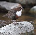
Dipper

Bullhead

Noble cancer

Adder


flora
On its course, the flora changes with the change of geological layers. In the upper Bühlertal there is a coniferous forest on the sandy soils ( Stuben sandstone , silica sandstone , reed sandstone ).
- In moist places you can often find the peat moss ( Sphagnum sp. ), The Blueberry ( Vaccinium myrtillus ), the club moss ( Lycopodium sp. ), Less frequently the fern ( spicant Blechnum ).
- The rough carnation ( Dianthus armeria ) can often be found on warm forest edges .
- Arnica ( Arnica montana ) is very rare .
Even in the gypsum keuper , the flora is similar to that of the shell limestone , but still has its own character. The forests now consist mainly of deciduous trees.
- In the central Bühlertal, the gnat-handelwort ( Gymnadenia conopsea ) and the common fringed gentian ( Gentianopsis ciliata ) grow on a few small heather areas.
The vegetation changes again on the steep slopes of the Muschelkalk.
- The stinking hellebore ( Helleborus foetidus ) often begins to bloom in February .
- In early spring, the bulbous larkspur ( Corydalis cava ) and the wild garlic ( Allium ursinum ) cover large areas in the deciduous forests.
- The liverwort ( Hepatica nobilis ), the wild hop ( Humulus lupulus ), the Turkish lily ( Lilium martagon ) and the clematis ( Clematis vitalba ) are not all that rare .
- On the other hand, the deer-tongue fern ( Phyllitis scolopendrium ) and the moon violet ( Lunaria rediviva ) are very rare .
- The narrow-lipped stendellum ( Epipactis leptochila ) was detected for the first time in 2005.
- Coming from Kochertal, the two-leaved squill ( Scilla bifolia ) has migrated a little into the Bühlertal.
- The forest yellow star ( Gagea lutea ) often grows in its vicinity .

Forest yellow star

Two-leaved squill

Smelly hellebore
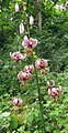
Turk's cap lily


Attractions
Castles and Palaces
The steep slopes of the Muschelkalktal valley from Untersontheim provided natural protection for the eight castles that lined the valley, especially between Vellberg and Geislingen. Apart from their neck trenches, there is hardly anything left of them today; some maps show more castle locations, in some cases the typical cuts in the spur location could also be of natural origin. From the source down, the locations in the valley and on the edge of the valley are:
- Kottspiel moated castle , on the outskirts of Bühlertann - Kottspiel , a still recognizable castle hill is located on the left in a river arch in a surrounding depression
- Tannenburg , Staufer shield wall castle near Bühlertann - Halden on a spur of the Ellwang Mountains , preserved and inhabited
- Obersontheim Castle , formerly the residence of a branch of the Limpurg tavern in Obersontheim , left a little above the river, is now a country hotel
- Castle or Veste Vellberg , in a prime location in front of the "Städtle" of Vellberg , lying on a spur above a 180 ° left loop of the river , has been preserved and is now used by the city administration
- Stöckenburg , opposite on the spur of the mouth of the Aalenbach , Celtic and later facilities, all removed, built on in the late Middle Ages with the town church on the outside
- Burg Buch , Spornburg to the left above the mouth of the Hirtenbach , a little north of Schwäbisch Hall - Buch , only the remains of the moat and hill can still be seen
- Anhausen castle ruins , on the left eaves below Schwäbisch Hall- Anhausen , remains of the castle hill and reconstructed wall fragment
- Hohenstein castle ruins , spur system on the left above a loop of the river near Schwäbisch Hall- Hohenstadt , rock moat and castle hill carved out of the rock
- Burgstall Hohenstatt , opposite the previous one on the flat Umlaufberg above a long, abandoned loop of the river, only a dump of rubble is recognizable
- Unterscheffach water castle , immediately before Wolpertshausen - Unterscheffach at the foot of the chapel, remains of a hill in a small depression
- Burgstall above the Heinlesklinge , south of Wolpertshausen- Reinsberg , hardly anything recognizable
- Burgstall Reinsburg , north via Unterscheffach and southwest of Reinsberg on a right-hand valley spur above the valley path, castle hill and rubble dump
- Burgstall north of the Kressenklinge , east of Wolpertshausen- Hopfach , in the spur position, hardly anything recognizable
- Hopfach castle ruins , north of Hopfach on the right Eichelberg mountain spur , installation on a large sloping clod in the Upper Muschelkalk, with a naturally formed neck ditch
- Bielriet castle ruins , north-north-west of Schwäbisch Hall- Wolpertsdorf on a left spur above Cröffelbach in the valley and the long and important valley path, in the Middle Ages the seat of Limpurg's taverns, neck ditch and rocky castle hill with few remains of walls
- Löwenburg castle ruins , spur system above the Bühler estuary at the beginning of the plateau, south via Braunsbach - Geislingen am Kocher , remains of the neck ditch, depression in a small rocky hill and debris pile on the spur ridge
Other sights

- In the valley near Neunbronn near Sulzdorf , the tusk of a mammoth was found in the 16th century , which was then interpreted as the horn of a unicorn . The tusk is still in the church of St. Michael in Schwäbisch Hall today .
- Dinosaur bones have been found in Geislingen am Kocher (see Geislingen am Kocher Bridge Museum ).
See also
Individual evidence
- ↑ Topographic map 1: 25,000 sheets 7025 Sulzbach-Laufen
- ↑ Geoportal Baden-Württemberg ( information )
- ↑ a b c State Institute for the Environment Baden-Württemberg (LUBW) ( information )
- ^ Flood forecast center , State Institute for the Environment Baden-Württemberg
- ↑ a b c Only the municipalities of Bühlerzell, Bühlertann, Obersontheim and Vellberg have the main towns on the river.
literature
- B. Kunz: The Bühler from the source to the mouth . Swiridoff Verlag 2003, ISBN 3-89929-007-0 .
Web links
- Map of the Bühler course and catchment area on: State Institute for the Environment Baden-Württemberg (LUBW) ( Notes )
- Measuring table sheets in the Deutsche Fotothek :
- 6824 Hall from 1930
- 6825 Ilshofen from 1937
- 6924 Gaildorf from 1930
- 6925 Obersontheim from 1936
- 7024 Gschwend from 1904
- 7025 Untergröningen from 1935
- 7026 Ellwangen from 1935
- Bühlertal tourism