
Ilshofen
| coat of arms | Germany map | |
|---|---|---|

|
Coordinates: 49 ° 10 ' N , 9 ° 55' E |
|
| Basic data | ||
| State : | Baden-Württemberg | |
| Administrative region : | Stuttgart | |
| County : | Schwäbisch Hall | |
| Height : | 441 m above sea level NHN | |
| Area : | 54.87 km 2 | |
| Residents: | 6584 (Dec. 31, 2018) | |
| Population density : | 120 inhabitants per km 2 | |
| Postal code : | 74532 | |
| Primaries : | 07904, 07905, 07906 | |
| License plate : | SHA, BK , CR | |
| Community key : | 08 1 27 043 | |
| LOCODE : | DE ICN | |
| City structure: | 7 districts | |
City administration address : |
Haller Strasse 1 74532 Ilshofen |
|
| Website : | ||
| Mayor : | Martin Blessing | |
| Location of the city of Ilshofen in the Schwäbisch Hall district | ||
  |
||

Ilshofen is a small town in the district of Schwäbisch Hall in the Franconian north-east of Baden-Württemberg , between the district town of Schwäbisch Hall and Crailsheim .
geography
Geographical location
The city of Ilshofen has a share in the natural areas of the Swabian-Franconian Forest Mountains , Kocher-Jagst Plains and Hohenloher-Haller Plains . Ilshofen is located on the plateau of the Hohenlohe plain between the valleys of Bühler in the southwest, Kocher in the west and Jagst in the north and east. In the south, the nearby Burgberg forms the last significant elevation of Burgberg foothills and Speltach Bay in front of the more distant Ellwang Mountains . A little to the south, the Schmerach flows past the city towards the west, it soon turns to the south-west and digs a steep, finally 100 m deep forest valley into the plateau before its confluence with the Bühler.
City structure
The district of Ilshofen is divided by the Dünsbach area ; the Obersteinach district, with a smaller area, is located west of the rest of the city, with the areas of the city of Gerabronn and the municipality of Wolpertshausen touching in between .
The city of Ilshofen consists of the districts Eckartshausen , Ilshofen, Obersteinach , Ruppertshofen and Unteraspach, which are spatially identical to the formerly independent municipalities with a total of 25 separately located villages . The city districts are officially named by the prefixed name of the city and, separated by a hyphen, followed by the name of the city quarters. The districts form residential districts in terms of the Baden-Württemberg municipal code . The town of Unterschmerach, which belongs to the Ilshofen district, is assigned to the Eckartshausen residential district for local elections.
- The Eckartshausen district includes the village of Eckartshausen and the hamlets of Großallmerspann and Oberschmerach as well as the abandoned village of Gaichshausen (Gaishausen).
- The Ilshofen district includes the town of Ilshofen, the hamlet of Unterschmerach and the Klingenhof farmstead, as well as the abandoned villages of Burg , Alt-Ilshofen and Erlach .
- The Obersteinach district includes the village of Obersteinach, the hamlets of Altenberg , Niedersteinach, Sandelsbronn, Windisch-Brachbach and Söllbot.
- The Ruppertshofen district includes the village of Ruppertshofen and the hamlets of Hessenau and Leofels as well as the abandoned villages of Birken (Hohebirken Castle?) And Guttershofen.
- The Unteraspach district includes the villages of Unteraspach, Gaugshausen and Oberaspach, the hamlets of Großstadel, Kerleweck, Oberscheffach and Steinbächle with the Burgstall castle ruins of Klingenfels and the farms of Kleinstadel, Lerchenhof and Lerchenmühle.
Division of space
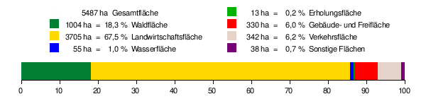
According to data from the State Statistical Office , as of 2014.
Neighboring communities
Neighboring cities and municipalities of Ilshofen are ( clockwise , starting in the north): Gerabronn, Kirchberg an der Jagst , Crailsheim, Vellberg , Schwäbisch Hall and Wolpertshausen. The northwestern exclave of Obersteinach is surrounded by Langenburg , Gerabronn , Wolpertshausen and Braunsbach . All neighboring communities belong to the Schwäbisch Hall district.
history


Early history
Ilshofen was first mentioned in 1288 as a property of the Count of Flügelau . In 1330 Ulleshoven was granted town charter by Emperor Ludwig the Bavarian , as Schwäbisch Hall already enjoyed. Due to the indebtedness of the owner, Count Ulrich von Hohenlohe, he had to sell the city to the imperial cities of Dinkelsbühl , Schwäbisch Hall and Rothenburg ob der Tauber in 1398 . During the First Margrave War , Ilshofen was besieged by Albrecht Achilles von Ansbach in 1449 and finally burned down.
In 1562 the imperial city of Schwäbisch Hall became the sole owner of Ilshofen (see Amt Ilshofen ).
The residents of Ilshofen suffered heavily in the Thirty Years' War. After the battle of Nördlingen , marauding troops spread the plague in southern Germany in 1634; In Ilshofen, around 80 people died of the introduced epidemic in just eleven weeks, and around 130 people died in the entire year 1634. Many residents of Ilshofen fled to nearby towns that seemed better fortified.
The territory of the imperial city of Schwäbisch Hall was occupied by Württemberg troops in the course of the coalition wars in 1802 and, in the course of mediatization , was annexed to the Duchy of Württemberg in 1803 . In 1802 Ilshofen also came under Württemberg rule.
Württemberg period from 1802 to 1945
In 1803 there were around 550 inhabitants living in Ilshofen, mainly from agriculture, as well as 29 horses and 232 cattle.
According to the new administrative structure in the Kingdom of Württemberg founded in 1806 , Ilshofen was assigned to the new Oberamt Hall .
The old town fortifications of Ilshofen were removed from 1841 with the exception of a few remains. Only the Hall gate tower from 1609 remained.
With the construction of the Hall – Crailsheim line from December 10, 1867, Ilshofen did not have a direct connection to the Württemberg railway network via the Eckartshausen station .
During the administrative reform during the Nazi era in Württemberg , Ilshofen came to the Schwäbisch Hall district in 1938 .
In the last days of World War II , almost two-thirds of the city was destroyed after fighting with scattered units of the Waffen-SS and subsequent American shelling and bombardment.
post war period
From 1945 Ilshofen belonged to the state of Württemberg-Baden in the American occupation zone .
After the formation of the Federal Republic of Germany and the state of Baden-Württemberg, the formation of the Ilshofen plain brought a series of changes. In addition to the establishment of a water association, the neighboring school association Ilshofner Ebene was set up in 1967. In the course of community reform in the 1970s, today's districts of Eckartshausen, Unteraspach, Obersteinach and Ruppertshofen were incorporated.
On October 14, 1995, the Ilshofen declaration of the FDP / DVP was passed in Ilshofen .
Incorporations
- December 1, 1971: Eckartshausen
- January 1, 1972: Obersteinach
- January 1, 1973: Ruppertshofen
- January 1, 1975: Unteraspach
Religions
Since the Reformation , Ilshofen has been predominantly evangelical; There are a total of four Protestant parishes, one each in Ilshofen, Oberaspach, Obersteinach and Ruppertshofen. The Catholic Church is represented in Großallmerspann, the New Apostolic Church in Ilshofen.
politics
Municipal council
The 2009 local elections led to the following result:
- Free electorate - Independent citizens' list 43.6% (+ 1.4) - 11 seats (+ 1)
- CDU and Free Voters 42.5% (- 1.3) - 11 seats (+ 1)
- Open list / SPD 14.0% (± 0.0) - 3 seats (=)
Local election 2018:
- After the 2018 election, the municipal council has 24 members.
mayor
From 1986 to 2018 Roland Wurmthaler headed the community. He was confirmed in office for a further eight years on January 24, 2010 with a voter turnout of 34% with over 95% of the votes. Martin Blessing followed him in 2018.
coat of arms
The blazon of the coat of arms reads: "In silver on a green ground a standing Lady Justice with a silver blindfold, blue dress and red cloak, in her raised left hand a golden balance, in the lowered right holding a golden sword."
Town twinning
- Kleinsölk (Austria), since 1972
- Pockau-Lengefeld (Saxony), since 1990
Culture and sights

Buildings
One of the most important castle ruins of the Staufer period in southwest Germany is Leofels Castle above the Jagsttal, which is owned by the city.
The Church of St. Petronella, built in 1830, has a tower that dates from the 16th century. It is the only church in Baden-Württemberg with this unusual name , although there is a similar variant at the Kaiserstuhl .
A donation made it possible in 2001 to convert the city tower into a culture tower . Regular exhibitions of local artists and local history topics take place here.
Ilshofen also has a modern town hall, now called Roland-Wurmthaler-Halle, which was built from 2004 to 2007 through extensive renovation and expansion of a previous town hall near the Hall gate tower by the Stuttgart architects Heckmann + Jung, formerly Heckmann. Kristel. Young , arose.

Economy and Infrastructure
traffic
Ilshofen is connected to the national road network via the federal motorway 6 ( Saarbrücken - Waidhaus ). In the Eckartshausen district there is a stop on the Crailsheim – Heilbronn railway line .
The city has several bus routes , including a. line 23 to Schwäbisch Hall and line 66 to Crailsheim (as of November 2004). It belongs to the Verkehrsverbund KreisVerkehr Schwäbisch Hall .
education
In 1971 the first construction phase of the rural education center in Ilshofen was completed, which has been expanded several times until today. Today pupils from the communities of Ilshofen, Wolpertshausen and Vellberg attend the Hermann Merz elementary , secondary and secondary school ; In addition, there is the Maria Montessori - special school . There are also four kindergartens in the city.
power supply
There are several wind turbines at Ruppertshofen .
Public facilities
In Ilshofen there is a police station, a notary's office, a branch of the district office with agricultural and veterinary office and the Ilshofen volunteer fire brigade .
freetime and sports
The TSV Ilshofen 1862 e. V. is the third largest association in the Schwäbisch Hall district with around 1,600 members in 30 departments. In addition to the large sports hall, a hard court and a 400 m tartan track, there are also three football fields available. In the Unteraspach district there is an outdoor pool with a children's pool and a 50-meter lane.
Personalities
Sons and daughters of the church
- Wilhelm Augst (1853–1913), coppersmith, member of the German Reichstag
- Dieter Fritz (* 1956), journalist at SWR
Web links
- all three in the description of the Oberamt Hall from 1847
- both in the description of the Oberamt Gerabronn from 1847
- Map of the urban area of Ilshofen on: State Institute for the Environment Baden-Württemberg (LUBW) ( information )
- Map of the city of Ilshofen on: Geoportal Baden-Württemberg ( information )
Individual evidence
- ↑ State Statistical Office Baden-Württemberg - Population by nationality and gender on December 31, 2018 (CSV file) ( help on this ).
- ↑ Natural areas of Baden-Württemberg . State Institute for the Environment, Measurements and Nature Conservation Baden-Württemberg, Stuttgart 2009
- ↑ Main statute of the city of Ilshofen from March 14, 2005 ( Memento from January 2, 2014 in the Internet Archive ). Accessed on July 20, 2020
- ↑ Ein Gewann Alt-Ilshofen is located between Ilshofen and Ruppertshofen a little east of the K 2542 on the upper Scherrbach ( 49 ° 11 ′ N , 9 ° 55 ′ E ).
- ↑ Ein Gewann Erlich is located about 1.7 km northwest of the city center, it mainly comprises a large forest island crossed by the motorway ( 49 ° 11 ′ N , 9 ° 54 ′ E ).
- ↑ A Won Guttershofen is close to some of the newer livestock buildings south of Leofels on the upper stone Gassenbach west of the Rothölzles ( 49 ° 12 ' N , 9 ° 55' O ).
- ^ The state of Baden-Württemberg. Official description according to districts and municipalities as well as the lost village of Bonazhof. Volume IV: Stuttgart district, Franconian and East Württemberg regional associations. Kohlhammer, Stuttgart 1980, ISBN 3-17-005708-1 . Pp. 491-496
- ↑ State Statistical Office, area since 1988 according to actual use for Ilshofen.
- ^ Regesta Imperii of Emperor Ludwig of Bavaria from August 7, 1330
- ^ Ilshofen declaration. Decision of the State Main Committee on October 14, 1995 in Ilshofen. FDP, accessed on June 22, 2016 .
- ↑ a b Federal Statistical Office (ed.): Historical municipality register for the Federal Republic of Germany. Name, border and key number changes in municipalities, counties and administrative districts from May 27, 1970 to December 31, 1982 . W. Kohlhammer, Stuttgart / Mainz 1983, ISBN 3-17-003263-1 , p. 456 .
- ^ Federal Statistical Office (ed.): Historical municipality directory for the Federal Republic of Germany. Name, border and key number changes in municipalities, counties and administrative districts from May 27, 1970 to December 31, 1982 . W. Kohlhammer, Stuttgart / Mainz 1983, ISBN 3-17-003263-1 , p. 457 .
- ^ Federal Statistical Office (ed.): Historical municipality directory for the Federal Republic of Germany. Name, border and key number changes in municipalities, counties and administrative districts from May 27, 1970 to December 31, 1982 . W. Kohlhammer, Stuttgart / Mainz 1983, ISBN 3-17-003263-1 , p. 468 .
- ^ Municipal council since 2018. Accessed on July 20, 2020
- ^ Elisabeth Schweikert: Martin Blessing appointed as the new BM . swp.de, March 22, 2018

Blaufelden | Braunsbach | Bühlertann | Bühlerzell | Crailsheim | Fichtenau | Fichtenberg | Frankenhardt | Gaildorf | Gerabronn | Ilshofen | Kirchberg an der Jagst | Kreßberg | Langenburg | Mainhardt | Michelbach an der Bilz | Michelfeld | Oberrot | Obersontheim | Rose garden | Red at the lake | Satteldorf | Schrozberg | Schwäbisch Hall | Stimpfach | Sulzbach-Laufen | Untermünkheim | Vellberg | Wallhausen | Wolpertshausen
District Eckartshausen : Eckartshausen | Großallmerspann | Oberschmerach
District Ilshofen: Ilshofen | Klingenhof | Unterschmerach
District Obersteinach : Altenberg | Niedersteinach | Obersteinach | Sandelsbronn | Söllbot | Windisch-Brachbach
District Ruppertshofen : Hessenau | Leofels | Ruppertshofen
Unteraspach district: Gaugshausen | Großstadel | Kerleweck | Kleinstadel | Lerchenhof | Lerchenmühle | Oberaspach | Oberscheffach | Steinbächle | Unteraspach