
Rose garden (Schwäbisch Hall district)
| coat of arms | Germany map | |
|---|---|---|

|
Coordinates: 49 ° 4 ' N , 9 ° 44' E |
|
| Basic data | ||
| State : | Baden-Württemberg | |
| Administrative region : | Stuttgart | |
| County : | Schwäbisch Hall | |
| Height : | 370 m above sea level NHN | |
| Area : | 31.01 km 2 | |
| Residents: | 5060 (December 31, 2018) | |
| Population density : | 163 inhabitants per km 2 | |
| Postal code : | 74538 | |
| Area code : | 0791 | |
| License plate : | SHA, BK , CR | |
| Community key : | 08 1 27 100 | |
| Address of the municipal administration: |
Hauptstrasse 39 74538 Rosengarten am Kocher |
|
| Website : | ||
| Mayor : | Julian Exchange | |
| Location of the community Rosengarten in the district of Schwäbisch Hall | ||
  |
||

Rosengarten is a municipality in the district of Schwäbisch Hall in the Franconian north-east of Baden-Württemberg . The community was formed on January 1, 1972 through the merger of the previously independent communities Rieden , Uttenhofen and Westheim .
geography
Geographical location
Rosengarten is part of the natural areas of the Swabian-Franconian Forest Mountains and Hohenloher-Haller Ebene . The community is located on the Kocher , the Bibers tributary to the Kocher and the flat area in between.
Neighboring communities
The community borders in the north and west on the district town of Schwäbisch Hall , in the east on Michelbach an der Bilz , in the south on the town of Gaildorf and Oberrot .
Community structure
The community Rosengarten consists of the formerly independent communities Westheim, Uttenhofen and Rieden. The former municipality of Rieden includes the village of Rieden , the hamlet of Sanzenbach with Sanzenbach castle stables , the Dendelbach, Kastenhof and Zimmertshaus farms, as well as the abandoned Landturm and Johanniterforsthaus villages . The former municipality of Uttenhofen includes the village of Uttenhofen , the hamlets of Raibach, Tullau and Wilhelmsglück , the Renkenbühl homestead and the Blumenhof house. The former municipality of Westheim includes the village of Westheim and the hamlets of Berghof, Vohenstein with the Vohenstein castle stables and brick mill, as well as the abandoned town of Walbruderhaus. The administration is based in Uttenhofen.
see also Rieden Castle (Schlösschen)
Buildings
Significant buildings in the community are the historic Marienkirche in Rieden, the Protestant Church of St. Martin in the Westheim district, which is dominant from the south due to its exposed location, the water tower in the Uttenhofen district, the castle in the Tullau district and the Sigismund chapel in the district Uttenhofen. There is also the churchyard chapel in the Westheim district and the Wolfgang Church in the Tullau district.
Division of space
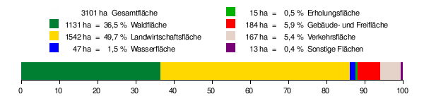
According to data from the State Statistical Office , as of 2014.
politics
mayor
- Ernst Weidner (1924–2012), 1972–1988
- Jürgen König (* 1961), 1988–2019
- Julian Tausch (* 1985), since 2019
Mayor Julian Tausch (non-party) was elected in May 2019 with 54.3% of the vote.
Mayor of the former municipalities
| Surname | Life dates | Term of office | Remarks |
|---|---|---|---|
| Glock, Friedrich | 1880-1934 | 1924-1934 | |
| Bauer, Erwin | 1909-2006 | 1934-1945 | |
| Eckstein, Heinrich | 1888-1961 | 1945-1948 | |
| Canz, Willi | 1920-1995 | 1948-1952 | |
| Frenz, Hermann | 1918-1987 | 1952-1971 |
| Surname | Life dates | Term of office | Remarks |
|---|---|---|---|
| Bräuninger, Michael | 1857-1909 | 1891-1909 | |
| Kübler, Eugene | 1879-1969 | 1909-1937 | |
| In short, Heinrich | 1894-1959 | 1938-1945 | First alderman |
| Dierolf, Friedrich | 1910-1955 | 1946-1947 | |
| Dierolf, Karl | 1919-1993 | 1947-1949 | |
| Frenz, Hermann | 1918-1987 | 1949-1971 |
| Surname | Life dates | Term of office | Remarks |
|---|---|---|---|
| Eisenmenger, Friedrich | 1846-1915 | 1874-1915 | |
| Henßler, Fritz | 1888-1938 | ? | Missing data |
| Kilb, Anton | 1886-1953 | 1922-1937 | |
| Bauer, Erwin | 1909-2006 | 1937-1945 | |
| Shy, Karl | 1903-1980 | 1946-1954 | |
| Weidner, Ernst | 1924-2012 | 1954-1971 |
All data according to the Rosengarten municipal website.
Economy and Infrastructure
Parts of the resident companies and traders have joined the Rosengarten trade and business association. V. (HGV) merged. This association organizes performance shows every several years.
education
There is a primary school in the Westheim district . Secondary schools are attended by the children of the community in Schwäbisch Hall, Michelbach an der Bilz or Gaildorf.
literature
- Topographic map 1: 25,000 Baden-Württemberg, as single sheet No. 6923 Sulzbach an der Murr and No. 6924 Gaildorf
Individual evidence
- ↑ State Statistical Office Baden-Württemberg - Population by nationality and gender on December 31, 2018 (CSV file) ( help on this ).
- ^ Federal Statistical Office (ed.): Historical municipality directory for the Federal Republic of Germany. Name, border and key number changes in municipalities, counties and administrative districts from May 27, 1970 to December 31, 1982 . W. Kohlhammer, Stuttgart / Mainz 1983, ISBN 3-17-003263-1 , p. 456 .
- ↑ Natural areas of Baden-Württemberg . State Institute for the Environment, Measurements and Nature Conservation Baden-Württemberg, Stuttgart 2009.
- ^ The state of Baden-Württemberg. Official description by district and municipality. Volume IV: Stuttgart district, Franconian and East Württemberg regional associations. Kohlhammer, Stuttgart 1980, ISBN 3-17-005708-1 . Pp. 555-558.
- ↑ State Statistical Office, area since 1988 according to actual use for rose garden.
- ↑ a b Mayor & Schultheißen. Rosengarten Mayor's Office, accessed on August 25, 2019 .
- ^ Südwest Presse Online-Dienst GmbH: Mayor election in Rosengarten: Julian Tausch is the new mayor of Rosengarten. May 27, 2019, accessed August 25, 2019 .
Web links
- Map of the community of Rosengarten on: State Agency for the Environment Baden-Württemberg (LUBW) ( information )

Blaufelden | Braunsbach | Bühlertann | Bühlerzell | Crailsheim | Fichtenau | Fichtenberg | Frankenhardt | Gaildorf | Gerabronn | Ilshofen | Kirchberg an der Jagst | Kreßberg | Langenburg | Mainhardt | Michelbach an der Bilz | Michelfeld | Oberrot | Obersontheim | Rose garden | Red at the lake | Satteldorf | Schrozberg | Schwäbisch Hall | Stimpfach | Sulzbach-Laufen | Untermünkheim | Vellberg | Wallhausen | Wolpertshausen