
Braunsbach
| coat of arms | Germany map | |
|---|---|---|

|
Coordinates: 49 ° 12 ' N , 9 ° 47' E |
|
| Basic data | ||
| State : | Baden-Württemberg | |
| Administrative region : | Stuttgart | |
| County : | Schwäbisch Hall | |
| Height : | 268 m above sea level NHN | |
| Area : | 52.85 km 2 | |
| Residents: | 2506 (December 31, 2018) | |
| Population density : | 47 inhabitants per km 2 | |
| Postcodes : | 74542, 74523 | |
| Area code : | 07906 | |
| License plate : | SHA, BK , CR | |
| Community key : | 08 1 27 009 | |
| LOCODE : | DE 235 | |
| Address of the municipal administration: |
Geislinger Strasse 11 74542 Braunsbach |
|
| Website : | ||
| Mayor : | Frank Harsch | |
| Location of the community Braunsbach in the district of Schwäbisch Hall | ||
  |
||

Braunsbach is a municipality in the Franconian region of Hohenlohe in the Schwäbisch Hall district in Baden-Württemberg .
geography
Geographical location
The eponymous capital Braunsbach is a good ten kilometers northeast of the district town of Schwäbisch Hall in the deeply cut Kochertal . Here, after the Bühler inflow, the digester runs northwards. Some steep blades run towards the Kocher from the Hohenlohe plain on both sides of the large valley cut.
Braunsbach is located at the inlet of the Orlacher Bach to the Kocher.
Upstream at the mouth of the Bühler is the larger town of Geislingen am Kocher, downstream is the larger town of Döttingen at the inlet of the Eschentaler Bach and Steinkirchen.
The other suburbs of the community Braunsbach are on the Hohenlohe plain on both sides of the Kocher valley or south of the Bühler estuary.
Neighboring communities
The community borders in the north on the district town of Künzelsau in the Hohenlohe district , in the east on the city of Langenburg in the district of Schwäbisch Hall , in the southeast on Wolpertshausen , in the south on the district town Schwäbisch Hall , in the southwest on Untermünkheim and finally in the west on Kupferzell , this again in Hohenlohe district.
Community structure
The municipality of Braunsbach with the municipalities of Arnsdorf, Döttingen, Geislingen am Kocher , Jungholzhausen, Orlach and Steinkirchen, which were independent until the municipal reform in Baden-Württemberg , includes 22 villages, hamlets, farms and houses. see also ruin Bachenstein

- Arnsdorf includes the village of Arnsdorf and the hamlets of Braunoldswiesen, Herdtlingshagen, Reisachshof, Rückertsbronn and Rückertshausen.
- The village of Braunsbach and the hamlet of Schaalhof belong to Braunsbach.
- The village of Döttingen belongs to Döttingen.
- Geislingen am Kocher includes the village of Geislingen am Kocher and the hamlets of Bühlerzimmer and Hergershof
- Jungholzhausen includes the village of Jungholzhausen, the hamlet of Zottishofen and the Dörrhof homestead.
- The village of Orlach and the hamlet of Elzhausen belong to Orlach.
- Steinkirchen includes the village of Steinkirchen and the hamlets of Sommerberg, Tierberg, Weilersbach and Winterberg.
In the municipality Brown Bach are several Outbound , now-defunct villages; Lautenbach and Lauterburg (in the area of the former municipality of Arnsdorf), Enningen or Nenningen, an "old castle" ( Enningen Castle ) on the Schaalberg, Gruonden and chapel for the seven siblings (possibly the chapel of Enningen) (in the area of the municipality of Braunsbach the local government reform), the abandoned farmstead Brand (in the area of the former municipality of Döttingen), Grimbach and Steffersbach (in the area of the former municipality of Geislingen am Kocher), Altholzhausen (no news, only as a field name) and the Braunsberger Hof, possibly identical to the Dörrhof (in the area of the former community Jungholzhausen), Bole (also Bohel), Hirschberg and Holzhausen (in the area of the former community Orlach).
Division of space
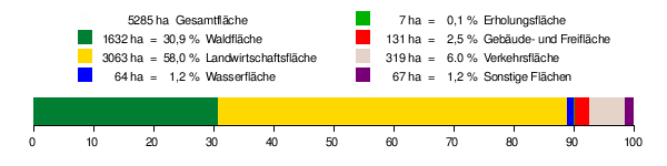
According to data from the State Statistical Office , as of 2014.
history
middle Ages
The current districts of Braunsbach belonged to Hall , Hohenlohe and Würzburg until the beginning of the 19th century . See also Braunsbach office .
secularization
1802 to 1806 they all came to Württemberg ( Kingdom since 1806 ), where they were assigned to the upper offices of Künzelsau and Hall . From 1938 they all belonged to the Hall district (from 1941 Schwäbisch Hall district ).
Time in World War II
In the American occupation of Germany came in Jung Holzhausen to a fierce battle between the 254th Infantry Regiment and pioneers of the armed forces, as well as a on 15 April 1945 SS - Infantry Company of the 17th SS Panzer Grenadier Division "Götz von Berlichingen" . The Americans suffered heavy losses in the fighting, but won and took numerous SS soldiers prisoner. The villagers counted 63 dead Germans. According to witness statements, the US soldiers murdered many of the prisoners of war. The exact number can no longer be determined, estimates range from 13 to 30 soldiers.
Merger
On February 1, 1972, the formerly independent communities of Arnsdorf, Braunsbach, Döttingen, Geislingen am Kocher, Jungholzhausen, Orlach and Steinkirchen merged to form the new community of Braunsbach.
Flood
On May 29, 2016, a storm in the region caused severe flooding with devastating damage. In the center of the Braunsbach, which is hardest hit, the Orlacher Bach and the smaller Schlossbach overflowed their banks and left several meters high of rubble made of stones, clay, cars and wedged old wood.
Likewise, the Grimmbach swelled , whose blades run and mouth a little upstream from Braunsbach are free of settlements and there damaged the valley road and its bridge.
politics
Municipal council
After the 2014 local elections, the council has 13 members.
Administrative association
The community is the seat of the community administration association "Braunsbach-Untermünkheim".
mayor
Frank Harsch was elected mayor in the first ballot in 2004 and was re-elected for a further eight years in 2012.
Partnerships
Braunsbach maintains partnership relationships with
- the French commune of Vouillé near Poitiers since 1987 and
- Arnsdorf, today part of the city of Penig in Saxony since 1990.
- We have been in contact with Zwierzyniec near Zamość in Poland since 1997.
The district of Döttingen also maintains friendly relationships with the municipality of the same name in Switzerland .
Attractions
,_Aquarell,_Braunsbach,_Schlo%C3%9F,_Eingangstor_in_der_s%C3%BCdl._Westwand_der_Umfassungsmauer_mit_s%C3%BCdlichem_Rundturm_(rechts)_und_Schlosskapelle,_Kirche_St._Bonifatius_(links).jpg)


- The Braunsbach Schloss , with constructional origin of 1250 in Braunsbach.
- The Protestant Bonifatius Church in the castle in Braunsbach.
- The baroque organ in the castle church in Braunsbach, the oldest parts of which go back to 1736, when Philipp Heinrich Hasenmaier created a small instrument that was expanded by Georg Ludwig Mezler in 1794.
- The Döttinger Tor in Braunsbach.
- The Schloss Döttingen in the district Dottingen.
- The animal mountain castle in the village of stone churches.
- The Kochertal Bridge , built from 1976 to 1979, became a symbol of the still young community and has also been included in their coat of arms. The 1,128 m long viaduct is supported by bridge piers up to 185 m high, which at the time were tallest in the world after it was built.
- On April 13, 2008, a rabbinate museum was opened in the old rabbinate . The city's synagogue was devastated by SA men during the November pogrom in 1938 and decades later incorporated into the new Burgenland Hall . Since 1978 a plaque at the entrance to the Rosenstein Hall has been commemorating the Jewish residents of the city who fell victim to the Shoah .
- The house of the former mayor JM Gronbach, Orlach (today Haus Schumm) known from the book "Das Mädchen von Orlach".
Sports
In the community of Braunsbach there is the TSV Braunsbach 1921.
In the suburb of Jungholzhausen is the shooting club Adlerauge Döttingen - Jungholzhausen with eight air rifle or air pistol tracks and an archery department.
Sons and daughters of the church
- Naphtali Berlinger (1876–1943), teacher and rabbi
Web links
ditto Döttingen
- Map of the community of Braunsbach on: State Institute for the Environment Baden-Württemberg (LUBW) ( Notes )
- Map of the village of Braunsbach on: Geoportal Baden-Württemberg ( information )
Individual evidence
- ↑ State Statistical Office Baden-Württemberg - Population by nationality and gender on December 31, 2018 (CSV file) ( help on this ).
- ^ The state of Baden-Württemberg. Official description by district and municipality. Volume IV: Stuttgart district, Franconian and East Württemberg regional associations. Kohlhammer, Stuttgart 1980, ISBN 3-17-005708-1 , pp. 412-418.
- ↑ State Statistical Office, area since 1988 according to actual use for Braunsbach.
- ^ The district of Schwäbisch Hall. Volume 1 . Thorbecke, Ostfildern 2005, ISBN 3-7995-1366-3 ( Baden-Württemberg - The country in its circles ), pp. 310–341.
- ↑ Description of the events in Jungholzhausen according to Harald Zigan: End of the war 1945 (part 10): US soldiers take bloody revenge in Jungholzhausen and Ilshofen in Hohenloher Tagblatt, Crailsheim, April 16, 2015 http://www.swp.de/crailsheim/zeitzeugen / End of war-1945-part-10-US-soldiers-take-bloody-revenge-in-Jungholzhausen-and-Ilshofen; art1214260,3166739 Klaus-Dietmar Henke : The American occupation of Germany . Oldenbourg, Munich 1995, ISBN 3-486-54141-2 ( sources and representations on contemporary history. Volume 27), pp. 926-927 and Uwe Jacobi : The end of the war. Scenes in 1944/45 in Heilbronn, in the Unterland and in Hohenlohe. 6th edition. Verlag Heilbronner Demokratie, Heilbronn 2005, p. 90. Henke reports “possibly 20”, Jacobi from 30 to 33 or 60 soldiers. Zigan reports “After the fighting, the villagers counted the bodies of 63 German soldiers who were indiscriminately shot by US soldiers in at least 13 cases, although they had already surrendered and laid down their weapons. Other sources name up to 30 murdered soldiers. "
- ^ Federal Statistical Office (ed.): Historical municipality directory for the Federal Republic of Germany. Name, border and key number changes in municipalities, counties and administrative districts from May 27, 1970 to December 31, 1982 . W. Kohlhammer, Stuttgart / Mainz 1983, ISBN 3-17-003263-1 , p. 456 .
- ^ The flood of Braunsbach , Spiegel-Online, May 30, 2016
- ↑ spiegel.de: Report one day after the storm
- ↑ Braunsbach after the storm: “Such forces of nature cannot be controlled”. In: Spiegel Online. May 30, 2016, accessed May 30, 2016 .
- ↑ http://www.braunsbach.de/index.php?id=63
- ^ Helmut Völkl : Organs in Württemberg. Hänssler, Neuhausen-Stuttgart 1986, ISBN 3-7751-1090-9 , p. 90.
- ↑ a b Braunsbach: Worth seeing
- ^ Website of the Rabbinate Museum
- ↑ Memorial sites for the victims of National Socialism. A documentation, Vol. I, Bonn 1995, p. 27, ISBN 3-89331-208-0 .

Blaufelden | Braunsbach | Bühlertann | Bühlerzell | Crailsheim | Fichtenau | Fichtenberg | Frankenhardt | Gaildorf | Gerabronn | Ilshofen | Kirchberg an der Jagst | Kreßberg | Langenburg | Mainhardt | Michelbach an der Bilz | Michelfeld | Oberrot | Obersontheim | Rose garden | Red at the lake | Satteldorf | Schrozberg | Schwäbisch Hall | Stimpfach | Sulzbach-Laufen | Untermünkheim | Vellberg | Wallhausen | Wolpertshausen