
Buhlertann
| coat of arms | Germany map | |
|---|---|---|

|
Coordinates: 49 ° 2 ' N , 9 ° 55' E |
|
| Basic data | ||
| State : | Baden-Württemberg | |
| Administrative region : | Stuttgart | |
| County : | Schwäbisch Hall | |
| Height : | 376 m above sea level NHN | |
| Area : | 23.59 km 2 | |
| Residents: | 3027 (Dec. 31, 2018) | |
| Population density : | 128 inhabitants per km 2 | |
| Postal code : | 74424 | |
| Primaries : | 07973, 07974 | |
| License plate : | SHA, BK , CR | |
| Community key : | 08 1 27 012 | |
| LOCODE : | DE BTX | |
| Address of the municipal administration: |
Hauptstrasse 12 74424 Bühlertann |
|
| Website : | ||
| Mayor : | Florian Fallenbüchel | |
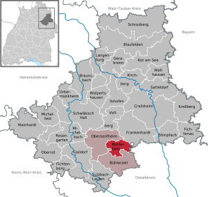
| Location of the community Bühlertann in the district of Schwäbisch Hall | ||
  |
||

Bühlertann is a municipality in the Schwäbisch Hall district in the Franconian north-east of Baden-Württemberg .
Surname
In the regional dialect, the main town that gives the municipality its name is called Dann [ dan ] for short .
geography
Geographical location
Bühlertann has a share in the natural areas of the Swabian-Franconian Forest Mountains and Hohenloher-Haller Ebene . The state-approved resort is located between the district town of Schwäbisch Hall (about 15 km as the crow flies in the northwest) and Ellwangen (about 19 km as the crow flies in the southeast) in the Bühler Valley , which flows to the Kocher about 17 km further north-northwest . The municipal area extends over an area of almost 24 km² between the deepest point in the north with almost 370 m (on the Bühler when it crosses to Obersontheim) and about 505 m in the east (north-northeast of Hettensberg in the Schäfer forest or east of the K 2628 to Kammerstatt in the Sauerberg forest).
geology


The Bühler, which runs through the Bühlertanner district roughly from south to north in a wide meadow, flows south of the main town almost entirely in the Gipskeuper ( Grabfeld formation ), on the remaining stretch in the Lettenkeuper ; Across the border in Obersontheim, there will be shell limestone for the first time . To the left of the river, a small ridge, the easternmost foothills of the Limpurger Mountains , separates the Bühlertal from the south-southeast running side valley of the Fischach, which flows into the suburb of Kottspiel . These little significant elevations usually end in the Gipskeuper, at one point (already in the Bühlerzell exclave, 447 m ) the reed sandstone is just reached. The heights to the right, part of the Ellwang Mountains , rise further and are more profiled; the sequence of layers mostly ends here in the pebble sandstone that forms a plateau around Fronrot ; on the eastern edge of the community near Kammerstatt there is even a single room sandstone . The ridges between the eastern side valleys often have the shape of flat surfaces, depending on the height in the estheria layers of the upper gypsum keuper, in the reed sandstone or in the silica sandstone. The first two often form steps on the valley slopes. In the northern municipality there are abandoned gypsum quarries in two places.
Neighboring communities
The community borders in the north on Obersontheim , in the northeast on Frankenhardt , in the east on Rosenberg in the Ostalbkreis , in the south on Bühlerzell and in the west again on Obersontheim or, for a small part, on the Bühlerzeller exclave Leippersberg.
Community structure
The community consists of 16 villages, hamlets, farms and houses. In addition to the eponymous main town Bühlertann, the hamlets Blashof, Fronrot , Halden, Hettensberg, Heuhof, Kottspiel , Vetterhöfe, Tannenburg Castle on a foothill of the Ellwang Mountains , Hof Himmelreich and the houses Avenmühle, Kreidelhaus, Niedermühle, Tannberghalden and Weidenmühle belong to the community. The site of the former fall house is now built over by a newer Bühlertann settlement. The localities of Altensusenberg, Bechrer, Gagernberg, Klumpertshof, Neherer, Rattelshofen, Suorenberg, Tanbach, Teutlershof and Wehen are in the district of Bühlertann.
- The eponymous capital Bühlertann is located on the narrowing of the Bühler floodplain, which previously moved from Kottspiel in the south in a wide flood plain to the north, taking in the Dammbach from the right. The old town center with the town hall, St. Georg and Gangolf chapel is located on a not very high, but flood-proof hill on the left side of the river close to a river crossing. Beyond the shallow valley basin of the small sea ditch that flows from the west , which finally runs underground and flows into the river bridge of Ellwanger Straße, further south was another, small settlement core with the old village mill that grew together with the larger one. The village was then expanded to the east into a valley bay on the other side of the Bühler crossing and to the north into an alluvial wedge towards the Niedermühle downstream. Later expansions completely filled the above-mentioned valley bay east of the Bühler, used the western slope foot of the vineyard that borders it to the north opposite the Niedermühle and built the hill in the triangle between the valley road running north (Obersontheimer Strasse), the northwestern L 1060 and the Eierbach hollow. The youngest designated new development area is in the west in the flat and here very wide hollow of the Seegraben.
Lines 12 ( Schwäbisch Hall - Bühlerzell ) and 13 ( Schwäbisch Hall - Ellwangen ) from the Schwäbisch Hall roundabout run through the main town, while lines 17A to Fischach valley and 49 to Gaildorf are the terminus here. In addition, the 12AC line handles school traffic jointly for Bühlertann and Bühlerzell.
- The Blashof homestead is located a little east of the hamlet of Halden at the foot of the Erbishalde, over which the western mountain spur of the Tannenburg falls south to the Avenbach , on a cul-de-sac and just under two and a half kilometers southeast of the main town.
- The hamlet of Fronrot is located about three and a half kilometers east-southeast of Bühlertann on the road from there to Ellwangen (L 1060) after its ascent to the plateau of the Ellwanger Mountains. It is a cleared foundation and today has around 200 residents and a chapel.
- The hamlet of Halden is located with two settlement cores about two kilometers southeast of the main town and south of the spur of the Tannenburg on a stepped terrain between the Ellwang Mountains and the Bühlertal floodplain. It has a stop for local school traffic.
- The hamlet of Hettensberg is about three and a half kilometers east of Bühlertann and a little north of Fronrot on the road from there to Gründelhardt , just on the plateau. In the center of the village there is a chapel and there used to be a bet that has since been filled up , from which the Hettensbach flows through a steep forest blade to the west to Dammbach and Bühler. The place is only approached by school traffic.
- The hamlet of Heuhof is located a little south of Halden on the terrain level already mentioned there and consists of only a few agricultural farms. A connecting road leads through the settlement from Halden to Bühlertalstrasse at the Weidenmühle.
- The hamlet of Kottspiel is located about two and a half kilometers south of Bühlertann in the Bühler valley, which runs into the Avenbach from the right and the Fischach from the left, has around 230 residents and a chapel and is served by line 12 of the roundabout. In both side valleys - at Fischachtal with an initial detour via Bühlerzell -Geifertshofen - side roads lead off from Bühlertalstrasse.
- The hamlet of Vetterhöfe is located about two kilometers east of the main town at mid-height between the valley cuts of the Dammbach in the south and the Nesselbach in the north. It consists of a few farmsteads, is only approached by school traffic and is located on a cul-de-sac for general traffic.
- The Tannenburg is located on a widely visible western mountain spur of the Ellwang Mountains about one and a half kilometers southeast of the main town, the castle building is joined by a single residential building in addition to farm buildings. The living space is on a cul-de-sac and is not served by local transport. A staircase on the slope to the south connects with Halden, the castle chapel sometimes serves its residents as a place of worship.
- Hof Himmelreich is less than half a kilometer northeast of the Vetterhöfe on the southern slope of the Nesselbach valley and can only be reached from there via a cul-de-sac.
- The Avenmühle is located about two and a half kilometers southeast of the main town on the Avenbach on a connecting road from Halden to Bühlerzell -Holenstein and is only served by school traffic.
- The Fallhaus stood in the middle of the now largely built-up valley bay in the east of Bühlertanner near today's Bühlertalhalle.
- The Kreidelhaus is a single house close to the Avenmühle.
- The single house Tannberghalden is located on the lower north-sided slope of the Tannenburgsporn next to the climbing section of the L 1060 to Ellwangen, about one and a half kilometers southeast of Bühlertann.
- The Niedermühle used to be the lower watermill of Bühlertann on the road to Obersontheim. In the 20th century, plaster of paris was sometimes burned here.
- The Weidenmühle is located about two kilometers south of the main town in the wide Bühlertalaue between Kottspiel and Bühlertann and has a stop for school traffic.
Division of space

According to data from the State Statistical Office , as of 2014.
history
During the time of the tribal duchies, Bühlertann was on the southern edge of the Duchy of Franconia . The place was first mentioned in a document in 1228. The Tannenburg and the town belonged to the dominion of the monastery and the prince provost of Ellwangen since the High Middle Ages . The place had market rights since the 14th century and was the seat of a noble bailiff of the provost's office. In Bühlertann and the district Halden there was a witch hunt from 1611 to 1614 . Nine women got into a witch trial that none survived. The last victim was Engla Kugler, the wife of the blacksmith Melchior Kugler, who died in 1614 by execution.
In anticipation of the 1803 effective Reichsdeputationshauptschluss , Bühlertann and the prince provost came to Württemberg in 1802 ( kingdom since 1806 ) and was assigned to the new Oberamt Ellwangen . For the year 1886 a population of 1509 is given, in 1939 it was 1365 people. Bühlertann was incorporated into the district of Schwäbisch Hall in 1938 as part of the administrative reform during the Nazi era in Württemberg . Since the place had become part of the American occupation zone after the Second World War , it had belonged to the newly founded state of Württemberg-Baden since 1945 , which was incorporated into the current state of Baden-Württemberg in 1952.
politics
Administrative association
The community is a member of the community administration association of Upper Bühlertal based in Obersontheim.
Municipal council
Since the local elections on May 25, 2014, the council has 13 members. It only consists of the “Active Citizens List” faction.
mayor
The police chief inspector Florian Fallenbüchel was elected as the new mayor in the first ballot in September 2019. He is the successor to Michael Dambacher , who has held the office since 2010 and has moved to Ellwangen as Lord Mayor . Its predecessor was Hans Weiss, who held the office for 32 years.
Partnerships
Bühlertann maintains friendly relations with the city of Gaspar near Blumenau in the state of Santa Catarina in southern Brazil . The descendants of many emigrants from Germany and other European countries live there, including those from Bühlertann.


Attractions
Buildings
- Tannenburg : a shield wall castle on a mountain spur about 1.5 km southeast of the town center
- Gangolfskapelle : Chapel at the former western exit, the rededicated tower was once part of the fortifications of the village
- Sankt Georg : Parish Church (built 1860)
Economy and Infrastructure
Established businesses
AS-Motor GmbH & Co. KG, company for high grass mowers
education
The school center in Bühlertann consists of elementary , secondary and technical secondary schools . Secondary schools are located in the nearby towns of Schwäbisch Hall , Crailsheim and Ellwangen .
traffic
Bühlertann is on the L 1060 from Schwäbisch Hall to Ellwangen; from this the L 1072 branches off in the main town to Bühlerzell in the upper Bühlertal.
The public transport concerned the KreisVerkehr Schwäbisch Hall with buses. Line 12 leads from Bühlerzell via Bühlertann and Obersontheim to Schwäbisch Hall . Line 13, which begins in the OstalbMobil tariff area in the Ostalbkreis, is alternately served by buses from both networks, it runs from Ellwangen to Bühlertann and then as an express line to Schwäbisch Hall. There are also less frequented bus routes to Gaildorf and Crailsheim as well as local feeder routes for line 12 for school transport.
Schwäbisch Hall is connected to the regional transport of the Deutsche Bahn via these bus routes. At the Schwäbisch Hall-Hessental train station and in Gaildorf , the closest stations are on the Schwäbisch Hall-Hessental – Waiblingen line for connections to Stuttgart , in Crailsheim to long-distance traffic to Nuremberg , in Ellwangen to regional traffic to Ulm ; the four train stations are about 13 to 23 kilometers away on the road.
Personalities
- Engla Kugler (–1614), wife of the blacksmith Melchior Kugler, was the last woman executed in a witch trial .
Web links
- Map of the municipality of Bühlertann on: State Institute for the Environment Baden-Württemberg (LUBW) ( information )
- Map of the village of Bühlertann on: Geoportal Baden-Württemberg ( information )
Individual evidence
- ↑ State Statistical Office Baden-Württemberg - Population by nationality and gender on December 31, 2018 (CSV file) ( help on this ).
- ↑ a b Fallenbüchel wins mayoral election in Bühlertann. In: SWR.de . September 30, 2019, accessed October 2, 2019 .
- ↑ Natural areas of Baden-Württemberg . State Institute for the Environment, Measurements and Nature Conservation Baden-Württemberg, Stuttgart 2009
- ↑ Topographic map 1: 25,000 Baden-Württemberg (north)
- ^ Geological map 1: 25,000 of Baden-Württemberg, sheet 6925
- ↑ According to the topographic map 1: 25,000 received in the name of the corridor of the same name, which stretches from the northwestern foot of the vineyard to the lower Nesselbachlauf and from the Bühler in the west to the municipality border towards the Obersontheimer Neuhof.
- ^ The state of Baden-Württemberg. Official description by district and municipality. Volume IV: Stuttgart district, Franconian and East Württemberg regional associations. Kohlhammer, Stuttgart 1980, ISBN 3-17-005708-1 , pp. 425-427.
- ^ Telephone information from the mayor's office in Bühlertann.
- ↑ State Statistical Office, area since 1988 according to actual use for Bühlertann.
- ↑ a b Max Miller , Gerhard Taddey (Ed.): Handbook of the historical sites of Germany Vol. 6, Baden-Württemberg (= Kröner's pocket edition. Vol. 276). 2nd improved and expanded edition, Alfred Kröner Verlag, Stuttgart 1980, ISBN 3-520-27602-X , p. 125
- ↑ Wolfgang Mährle: "Oh woe to the poor souls." Witch persecution in the prince provost of Ellwangen (1588–1694). In: Johannes Dillinger , Thomas Fritz, Wolfgang Mährle: Damned to fire. The witch hunts in the county of Hohenberg, the imperial city of Reutlingen and the prince provost of Ellwangen. Edited by the Institute for Historical Regional Studies and Historical Auxiliary Sciences at the University of Tübingen, Stuttgart 1998, pp. 325–500, especially pp. 453–476.
- ↑ In the description of the Oberamt Ellwangen
- ↑ http://www.buehlertann.de/index.php?id=91
- ↑ komm.on.line GmbH - www.kommonline.de: Ratsinfo Bühlertann. (No longer available online.) Archived from the original on September 25, 2018 ; accessed on September 25, 2018 . Info: The archive link was inserted automatically and has not yet been checked. Please check the original and archive link according to the instructions and then remove this notice.

Blaufelden | Braunsbach | Bühlertann | Bühlerzell | Crailsheim | Fichtenau | Fichtenberg | Frankenhardt | Gaildorf | Gerabronn | Ilshofen | Kirchberg an der Jagst | Kreßberg | Langenburg | Mainhardt | Michelbach an der Bilz | Michelfeld | Oberrot | Obersontheim | Rose garden | Red at the lake | Satteldorf | Schrozberg | Schwäbisch Hall | Stimpfach | Sulzbach-Laufen | Untermünkheim | Vellberg | Wallhausen | Wolpertshausen
Aven mill | Blashof | Bühlertann | Fall House | Front red | Heaps | Hettensberg | Hay yard | Kingdom of Heaven | Kottspiel | Chalk house | Niedermühle | Tannberghalden | Tannenburg | Vetterhöfe | Willow mill