
Gerabronn
| coat of arms | Germany map | |
|---|---|---|

|
Coordinates: 49 ° 15 ' N , 9 ° 55' E |
|
| Basic data | ||
| State : | Baden-Württemberg | |
| Administrative region : | Stuttgart | |
| County : | Schwäbisch Hall | |
| Height : | 460 m above sea level NHN | |
| Area : | 40.38 km 2 | |
| Residents: | 4270 (December 31, 2018) | |
| Population density : | 106 inhabitants per km 2 | |
| Postcodes : | 74582, 74585 | |
| Area code : | 07952 | |
| License plate : | SHA, BK , CR | |
| Community key : | 08 1 27 032 | |
| LOCODE : | DE GBN | |
| City structure: | 5 districts | |
City administration address : |
Blaufeldener Strasse 14 74582 Gerabronn |
|
| Website : | ||
| Mayor : | Christian Mauch | |
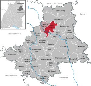
| Location of the city of Gerabronn in the Schwäbisch Hall district | ||
  |
||

Gerabronn is a town in the Hohenlohe region , in the Schwäbisch Hall district in the Franconian north-east of Baden-Württemberg .
geography
Gerabronn is located 422 to 460 meters above sea level on a hill in the Hohenlohe plain . Gerabronn has 48 natural monuments , u. a. some sinkholes .
Neighboring communities
The city borders in the north on Blaufelden , in the east on Rot am See , in the south on the cities of Kirchberg an der Jagst and Ilshofen as well as the community Wolpertshausen and in the west on the city of Langenburg .
City structure
The town of Gerabronn, consisting of the formerly independent communities Amlishagen , Dünsbach, Gerabronn and Michelbach an der Heide, includes 16 other villages, hamlets, farms and houses in addition to the core town of Gerabronn. The former municipality of Amlishagen includes the village of Amlishagen, the farms Hammerschmiede, Horschhof and Ziegelhof and the Mühle house, as well as the abandoned villages of Horschhof and Schafhof. The former community of Dünsbach includes the village of Dünsbach, the hamlets of Elpershofen, Großforst, Kleinforst and Morstein (with Morstein Castle ) and the Hubertushof farmstead as well as the villages of Höflein and Reichenhofen. The town of Gerabronn within the boundaries of December 31, 1971 includes the town of Gerabronn, the hamlets of Bügenstegen, Oberweiler (reunified from Wittenweiler in 1972), Rückershagen and Unterweiler (reunited from Wittenweiler in 1972) and the Himmelreichshof farm as well as the abandoned villages of Dennenweiler, Eckershagen and Fuchshof . The former municipality of Michelbach an der Heide includes the village of Michelbach an der Heide, the hamlets of Binselberg, Liebesdorf, Rechenhausen and Seibotenberg and the Kupferhof farm as well as the localities of Hezelhof and Rüddern that have been abandoned.
Division of space

According to data from the State Statistical Office , as of 2014.
history
Until the 19th century
Gerabronn developed from a village that was probably founded in the 10th century. Originally called Gerhiltebrunnen, it was also called Gerolzbrunn, Geroldbrunn, Gerltbrunn or Gerhartsbrunn until the current name came into use in the 17th century. The village was first mentioned in a document in 1226, when the area came under the rule of the Bishop of Würzburg . Between 1500 and 1806 it belonged to the Franconian Empire . In 1525 the residents took part in the Peasants' War. After the defeat of the farmers, several residents of Gerabronn were beheaded.
Gerabronn was only a village until the 19th century, but received market rights as early as 1412. Gerabronn had been part of the burgraviate of Nuremberg since 1399 and finally came to the margraviate of Ansbach in 1530 after several pledges . In the course of the territorial changes during the coalition wars, Gerabronn fell to Prussia in 1792 , then to Bavaria in 1806 and finally to the Kingdom of Württemberg on the basis of the border treaty of 1810 .
Württemberg time
Gerabronn became the seat of the upper office of the same name in 1811 , which corresponded to today's district, and was thus responsible for the administration of the associated area. However, it was not until 1886 that Gerabronn were granted city rights. The industrialization and in 1900 with the opening of the railway line Blaufelden-Langenburg made access to the network of Württembergische Eisenbahn promoted the growth of the city. An important advocate and initiator of the connection was the later honorary citizen of the city of Israel Landauer .
20th century
During the Nazi era in Württemberg , the Oberamt Gerabronn was renamed the Gerabronn district in 1934 and dissolved in 1938. The city became part of the Crailsheim district . In 1945 Gerabronn fell into the American zone of occupation and thus belonged to the newly founded state of Württemberg-Baden . With the founding of Baden-Württemberg in 1952, Gerabronn became part of the current federal state. In 1973 the district reform took place in Baden-Württemberg , when the city became part of the Schwäbisch Hall district .
Incorporations
On January 1, 1972, the previously independent municipality Amlishagen was incorporated. The districts of Oberweiler and Unterweiler, which belonged to Wittenweiler until the end of 1971, were transferred from the municipality of Blaufelden to Gerabronn on June 1, 1972 . Dünsbach came to Gerabronn on January 1, 1973. Michelbach an der Heide finally followed on January 1, 1975.
religion
Originally in relation to Michelbach an der Heide to the Diocese of Fulda, in relation to the other districts to the Diocese of Würzburg, since the 16th century belonging to the Margraviate of Brandenburg-Ansbach, the Reformation was introduced in and around Gerabronn in 1534/36 from Ansbach. Even before that, in 1561 in Gerabronn itself, parishes were set up in today's districts, which became part of Württemberg in 1810 with Hohenlohe, Crailsheim and the other New Württemberg areas. The area is still predominantly evangelical today. The four evangelical parishes of Amlishagen, Dünsbach, Gerabronn and Michelbach an er Heide, which are still legally independent , belong to a single overall evangelical parish of Gerabronn in the church district of Blaufelden of the Evangelical Church in Württemberg . The individual communities remain. You work closely together in administration and in your external appearance.
The Catholic Christians who increasingly moved here after the Second World War were given their own church in 1957, the Heiliggeist Church in Gerabronn .
politics
Municipal council
The 2019 local elections brought the following results:
mayor
Klaus Dieter Schumm was elected mayor in 1996 and was confirmed in office in 2004 and 2012. Schumm resigned prematurely on April 30, 2017. Christian Mauch was elected as his successor in March 2017.
Administrative community
Gerabronn is the seat of the agreed administrative community of the cities of Gerabronn and Langenburg.
coat of arms
The blazon of the coat of arms reads: "In a shield quartered with silver and black in the first and fourth fields, a soaring black horse."
Partnerships
The city of Gerabronn maintains a partnership with Nouan-le-Fuzelier in the Loir-et-Cher department in France .
Economy and Infrastructure
traffic
Between 1900 and 1996 Gerabronn and Oberweiler were connected to the railway network via the Blaufelden – Langenburg line. The Royal Württemberg State Railways built the Gerabronner station building as a unit station of type IIIa. Passenger traffic on the route ceased in 1963.

Gerabronn around 1900
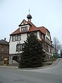
Gerabronn town hall

Gerabronn city gate

Evangelical Church Gerabronn

The disused Gerabronn train station


Culture and sights
Churches
- Evangelical Katharinenkirche Amlishagen : After the previous church and the village were destroyed by fire in the summer of 1760, the churchwas rebuiltin margrave styleon behalf of the castle and patron saint Gottfried Freiherr vom Holtz by the Hohenlohe court carpenter Leonhard Joseph Ernst from Kirchberg / Jagst. With the castle, palace, former town hall, former school, inn and rectory, it forms an ensemble on the church square. Craftsmen from Kirchberg an der Jagst (sculptor Ritter, master carpenter Johann Jakob Pfirsch), Johann Conrad Mögeling from Amlishagen and the Künzelsau sculptor Johann Andreas Sommer (1716-77) were in for the conception and design of the Markgräfler wall (Ansbacher pulpit wall) made of wood and stucco marble highly upright cross shape responsible. It consists of an altar, pulpit, organ loft and parterre doors for the walk around the altar at the reception of the Lord's Supper. The Katharinenkirche contains a north and south pore as well as a west gallery with a former patronage room or rulership with the coat of arms of the Lords of Holtz, a crypt and several individual graves in the floor as well as Johannes Allgeyer's organ from 1763.
- Evangelical Church of the Resurrection in Dünsbach : It was rebuilt in 1973 by the Stuttgart architect Johannes Wetzel (1926-2006) after the previous parish church, the castle church in Morstein , burned out on the morning of Christmas Eve 1969. The wife of the architect and artist Gertrud Angelika Wetzel artistically designed the altar and the south wall window with colored concrete glass (wavy lines) as well as the altar, font and pulpit in shell limestone and cast aluminum.
- Evangelical Church Peter and Paul, Gerabronn : A chapel Peter and Paul was built in 1423. The Lords of Berlichingen founded a chaplain on it, which belonged to the parish of Michelbach an der Heide. In 1461 it was raised to an independent parish. Instead of the chapel , the current church was built in the Querkirchen conception as an almost square hall in the margrave style in 1742–1751 by architect Leopoldo Retti according to plans by Johann David Steingruber , master builder of the former margraviate of Ansbach . The typical pulpit-altar organ wall was in the west on the tower side, opposite the patron's box. The demands for a modernized worship service led to a complete redesign of the interior in 1967. The commissioned architect Peter Haag from Schorndorf had not only both galleries removed, but also the pulpit wall, the modest gem of the church, and the transverse church concept. The altar and pulpit are now placed in a modern form on the south wall. The local artist Werner Grund created a symbolic wall mosaic in 1971, which takes up the center of the altar cross again and wants to clarify the rays emanating from there. The artist Winfried Richter from Gerabronn-Morstein created acrylic-based murals in 1995, tone on tone with the wall color, with the namesake of the church, Peter and Paul. From the time before the interior redesign, there is still the color-glazed round window (1933) by the expressionist artist Ernst H. Graeser with a representation of Christ. Two of his smaller windows were removed during the redesign.
- Evangelical Church of St. Bonifatius and Burkhard, Michelbach an der Heide : The church in the walled cemetery, already mentioned in 1245, is early Gothic with a Romanesque rectangular choir (Gothic tracery east window, covered inside by the large choir organ), an additional very small apse and tooth-cut friezes on the east gable. Verges and the cornice . It has a Baroque pulpit from 1683. The ship was rebuilt in 1914/15 by the architect Theodor Dolmetsch and in the north-western corner between the west tower and the nave, a round stair tower was added for access to the gallery.
- Evangelical St. Wendelin Chapel Rückershagen : The St. Wendelin chapel in the Gerabronner hamlet Rückershagen, first mentioned in 1499, is a late Gothic choir tower and has a cross-rib vaulted choir. The building shows that both the tower and the ship used to be higher. The dividing wall between tower and nave contains Romanesque envy faces on the outside, the Gothic windows in the nave are partly walled up in the pointed arches, partly with tracery or decorative arches.
Castles and Palaces


- In the suburb of Morstein is the Morstein Castle , one of the castles of the Barons of Crailsheim (currently no visits).
- In the suburb of Amlishagen, Amlishagen Castle , an old castle and palace complex, can be visited.
Regular events
- Gerabronn horse market, every year on Shrove Tuesday
- Heimattage Dünsbach, every 5 years at Pentecost in the Dünsbach district, most recently in 2015
societies
- The local group Gerabronn of the Swabian Alb Association was awarded the Eichendorff plaque in 2001.
Personalities
Honorary citizen
- Israel Landauer (1843–1913), German banker, manufacturer and benefactor
sons and daughters of the town
- Israel Landauer (1843–1913), banker, manufacturer and benefactor
- Gottlob Egelhaaf (1848–1934) politician and member of the state parliament ( DVP )
- Gustav Regelmann (1880–1947), senior magistrate and district administrator of Rottweil
- Fritz Frank (* 1923 in Großforst), writer, founder of Leofel's castle theater
- Manfred Wankmüller (1924–1988), writer
- Rezzo Schlauch (* 1947), lawyer, politician ( Alliance 90 / The Greens )
- Joschka Fischer (* 1948), politician (Bündnis 90 / Die Grünen), Federal Foreign Minister and Vice Chancellor 1998–2005
- Werner Grund (1919–2006), painter
literature
- Johann Kaspar Bundschuh : Gerabronn . In: Geographical Statistical-Topographical Lexicon of Franconia . tape 2 : El-H . Verlag der Stettinische Buchhandlung, Ulm 1800, DNB 790364298 , OCLC 833753081 , Sp. 299 ( digitized version ).
- Gottfried Stieber: Gerabronn . In: Historical and topographical news from the Principality of Brandenburg-Onolzbach . Johann Jacob Enderes, Schwabach 1761, p. 392-394 ( digitized version ).
- Gottfried Stieber: Michelbach an der Hayd . In: Historical and topographical news from the Principality of Brandenburg-Onolzbach . Johann Jacob Enderes, Schwabach 1761, p. 589-590 ( digitized version ).
Web links
- City website
- LEO-BW, discover regional studies online , Gerabronn
Individual evidence
- ↑ State Statistical Office Baden-Württemberg - Population by nationality and gender on December 31, 2018 (CSV file) ( help on this ).
- ^ The state of Baden-Württemberg. Official description by district and municipality. Volume IV: Stuttgart district, Franconian and East Württemberg regional associations. Kohlhammer, Stuttgart 1980, ISBN 3-17-005708-1 . Pp. 481-487
- ↑ State Statistical Office, area since 1988 according to actual use for Gerabronn.
- ^ Federal Statistical Office (ed.): Historical municipality directory for the Federal Republic of Germany. Name, border and key number changes in municipalities, counties and administrative districts from May 27, 1970 to December 31, 1982 . W. Kohlhammer, Stuttgart / Mainz 1983, ISBN 3-17-003263-1 , p. 447 f. and 468 .
- ^ Website of the Evangelical General Church Community of Gerabronn
- ↑ Source: statistik-bw.de
- ↑ http://www.swp.de/crailsheim/lokales/landkreis_schwaebisch_hall/klaus-dieter-schumm-tritt-ab-14005184.html
- ↑ http://www.swr.de/swraktuell/bw/heilbronn/neuer-buergermeister-in-gerabronn-christian-mauch-uebergluecklich/-/id=1562/did=19173836/nid=1562/ysikou/index.html
- ^ Rainer Stein: The Württemberg standard station on branch lines . In: Eisenbahn-Journal Württemberg-Report . tape 1 , no. V / 96 . Merker, Fürstenfeldbruck 1996, ISBN 3-922404-96-0 , p. 80-83 .
- ↑ Hartmut Speck, Sven-Uwe Bürger: Our parish church St. Katharina in Amlishagen ; see [1]
- ↑ Hansgeorg Kraft: Foray through the history of the Evangelical Church Community in Dünsbach ; ed. Ev. Church community Dünsbach, revised version - August 2009
- ↑ Hansgeorg Kraft: When Stones Preach - The Building of the Church of Resurrection in Dünsbach ; Dünsbach 2009
- ↑ Historical working group Gerabronn (ed.): From gate to gate. History and stories of the main street ; Self-published, Gerabronn 2016
- ↑ Planning documents in the architecture museum of the Technical University of Munich see [2]
- ↑ Gerhard Steidle: Our St. Wendelinskapelle zu Rückershagen - can be seen see [3]
- ↑ Honors in sheets of the Swabian Alb Association, issue 2/2002, p. 26
- ↑ Portrait of Fritz Frank at Hohenloher-land.de ( memento of the original from October 29, 2007 in the Internet Archive ) Info: The archive link was automatically inserted and not yet checked. Please check the original and archive link according to the instructions and then remove this notice. (accessed June 14, 2008)
- ↑ Homepage of Werner Grund's work (accessed June 14, 2016)

Blaufelden | Braunsbach | Bühlertann | Bühlerzell | Crailsheim | Fichtenau | Fichtenberg | Frankenhardt | Gaildorf | Gerabronn | Ilshofen | Kirchberg an der Jagst | Kreßberg | Langenburg | Mainhardt | Michelbach an der Bilz | Michelfeld | Oberrot | Obersontheim | Rose garden | Red at the lake | Satteldorf | Schrozberg | Schwäbisch Hall | Stimpfach | Sulzbach-Laufen | Untermünkheim | Vellberg | Wallhausen | Wolpertshausen