Burgberg Vorhöhen and Speltach Bay
| Burgberg Vorhöhen and Speltach Bay | ||
|---|---|---|
|
Burgberg foothills and Speltach Bay in the northeast of the Swabian-Franconian Forest Mountains natural area |
||
| location | Schwäbisch Hall district ; Baden-Württemberg ( Germany ) | |
| part of |
Ellwang Mountains and edge heights in the Swabian-Franconian Forest Mountains |
|
|
|
||
| Coordinates | 49 ° 6 ′ N , 10 ° 0 ′ E | |
| rock | Keuper | |
|
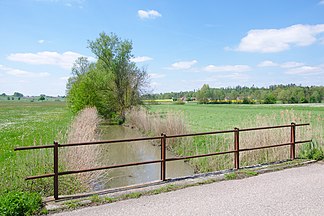
The Speltach near the Gründisches Brunnen |
||
The Burgberg-Vorhöhen and Speltachbucht are according to the structure of the manual of the natural spatial structure of Germany by Meynen / Schmithüsen (1953–1962) the natural spatial sub- unit 108.71 of the Swabian-Franconian forest mountains (108) in the Swabian Keuper-Lias-Land (10). Together with the sub- unit Ellwanger Mountains (108.70) adjacent to the south, they form the sub-unit 108.7 Ellwanger Mountains and Edge Heights .
Geographical location
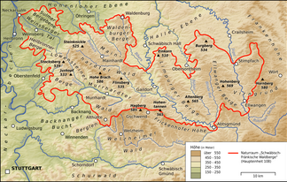
The Burgberg Vorhöhen and Speltachbucht lie in the northeast of the Swabian-Franconian Forest Mountains in northeastern Baden-Württemberg . It is named after the castle hill near the village of Oberspeltach in the community of Frankenhardt and the small river Speltach , which mostly runs along the boundary of this community , both in the district of Schwäbisch Hall .
The Burgberg-Vorhöhen and Speltachbucht border in the west on the natural spatial unit Vellberger Bucht (127.5), in the northwest and north on the Haller level (127.40) and in the northeast on the Crailsheimer Bucht (127.6), all in the natural area Hohenloher and Haller level (127 ) the Neckar- and Tauber-Gäuplatten (12), as well as in the east to the Crailsheimer Hardt (114.00) in the natural area Frankenhöhe (114) of the Franconian Keuper-Lias-Land (11).
geology
The Burgberg foothills are heights in front of the Ellwang Mountains, the upper Keup layers of which have already been removed from a tectonically high position. Only in the south is the silica sandstone preserved as a top layer , but here too it is broken up into individual ridges separated from the closed strata of the Ellwang Mountains by the tributaries east to the Jagst and west to the Bühler . Further to the north, the heights of 500 m are made of reed sandstone and north of the Speltach from the geologically even deeper gypsum keuper . The Burgberg (534 m) towers over the ridges as a witness mountain with silica sandstone, away from erosion .
The foreheads frame the bay cleared by the Speltach and its tributaries in the softer layers of gypsum keuper. Since the transition to the fore-hills is fluid and the ecological differences between the two are small, fore-hills and the bay, also known as the Speltachgrund, have been combined into a common natural spatial sub-unit.
The soils consist of podsolic brown earth above the reed and silica sandstone, and tough clay and loam above the gypsum keuper .
climate
The climate of the foothills and the bay is relatively cool.
vegetation
As in the Ellwang Mountains, the natural vegetation is the beech-fir forest, on the wooded heights the spruce forest dominates, with beech and oak mixed together. The bay is almost free of forests, meadows and fields predominate here.
colonization
Most of the settlements are hamlets, a few villages.
Individual evidence
- ↑ a b c d e f Wolf-Dieter Sick : Geographical land survey: The natural space units on sheet 162 Rothenburg o. D. Deaf. Federal Institute for Regional Studies, Bad Godesberg 1962. → Online map (PDF; 4.7 MB)


