
Michelfeld
| coat of arms | Germany map | |
|---|---|---|

|
Coordinates: 49 ° 6 ' N , 9 ° 41' E |
|
| Basic data | ||
| State : | Baden-Württemberg | |
| Administrative region : | Stuttgart | |
| County : | Schwäbisch Hall | |
| Height : | 361 m above sea level NHN | |
| Area : | 35.22 km 2 | |
| Residents: | 3799 (December 31, 2018) | |
| Population density : | 108 inhabitants per km 2 | |
| Postal code : | 74545 | |
| Primaries : | 0791, 07903, 07949 | |
| License plate : | SHA, BK , CR | |
| Community key : | 08 1 27 059 | |
| LOCODE : | DE MCF | |
| Address of the municipal administration: |
Haller Strasse 35 74545 Michelfeld |
|
| Website : | ||
| Mayor : | Wolfgang Binnig | |
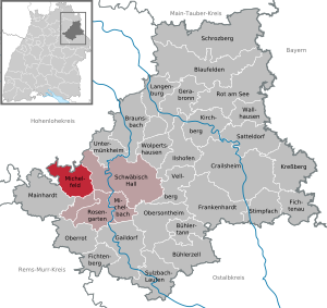
| Location of the municipality of Michelfeld in the Schwäbisch Hall district | ||
  |
||

Michelfeld is a municipality in the Schwäbisch Hall district in the Franconian north-east of Baden-Württemberg .
geography
Geographical location
Michelfeld is 354 to 509 meters above sea level, around five kilometers west of the district town of Schwäbisch Hall . The community has a share in the natural areas of the Swabian-Franconian Forest Mountains and Hohenloher-Haller Ebene .
The eponymous main town lies in the flat ground and on the left slope of the valley of the Beaver , which emerges from the Waldenburg mountains into the hilly landscape of the rose garden here in the south-south-east run . The village and valley are crossed by the federal road 14 coming from Schwäbisch Hall , which then climbs the plateau of the Mainhardt Forest in the west via the so-called Rote Steige . The village of Gnadental further up in the still narrow Biberstal also has a fairly large population. The largest part of the municipality is located north and northwest of Michelfeld on the rough and wooded plateaus of the Waldenburg mountains on both sides of the valley, over which many small hamlets and farms are scattered.
Neighboring communities
Michelfeld borders in the east on the urban area of Schwäbisch Hall, in the south-west on Mainhardt and in the north-west on Pfedelbach and the city of Waldenburg , both in the Hohenlohe district .
Community structure
The municipality of Michelfeld includes 33 villages, hamlets, farms and houses.
- The former community Gnadental includes the village Gnadental, the hamlet Büchelberg and the farms Eichelberg, Forsthaus, Vorderziegelhalden and Haus Winterrain as well as the abandoned villages Jagdhaus and Ziegelhalde.
- The municipality of Michelfeld in the territory of June 30, 1971 includes the village Michelfeld, the hamlets Blindheim , Eichholz, Erlin, Forst, Hahnenbusch, Kiesberg, Koppelinshof, Lemberg, Leoweiler, Lindachshof, Neunkirchen, Rinnen, Schöpperg, Wagrain and Witzmannsweiler, the farms Baierbach, Baumgarten, Bürkhof, Mäurershäusle, Messersmühle, Molkenstein (with Burgstall Molkenstein ), Pfeiffershäusle, Rote Steige and the houses Buchernhof, Landturm and Lemberghaus as well as the abandoned villages Egelsee, Einsiedelei, Schneidemühle and Sezershof.
For the purpose of carrying out a false suburb election , the municipality is divided into three so-called "residential districts" for local elections :
- Michelfeld with the towns of Michelfeld, Baumgarten, Buchernhof, Bürkhof, Forst, Kerz industrial park, Koppelinshof, Landturm, Leoweiler, Lindachshof, Molkenstein and Rote Steige;
- Gnadental with the places Gnadental, Büchelberg, Eichelberg, Forsthaus, Vorderziegelhalden and Winterrain;
- Neunkirchen / Rinnen with the places Neunkirchen, Rinnen (with Burgstall Rinnen ), Baierbach, Blindheim , Eichholz, Erlin, Hahnenbusch, Lemberg, Lemberghaus, Messersmühle, Schöpperg, Wagrain and Witzmannsweiler
Division of space

According to data from the State Statistical Office , as of 2014.
history
Michelfeld
Originally belonging to the local nobility of those von Michelfeld , the place came over time into the possession of the Benedictine monastery Comburg , which sold it to the city of Schwäbisch Hall in 1521 due to financial difficulties . Michelfeld became part of the land holdings of the former imperial city of Hall . However, the area of today's old community was subordinate to two different, Hallic offices. Michelfeld itself, as well as the Landturm, Leoweiler, Molkenstein and Rotensteige were subordinate to the Rosengarten office . All other places belonged to the Kocheneck office .
After the imperial city was dissolved and the Hall territories were taken over by Württemberg in 1802, the community belonged to the newly established Württemberg Oberamt Hall , from which the Hall district emerged in 1934 and the Schwäbisch Hall district in 1941 .
Mercy Valley
The current district of Gnadental was outside Halle territory and belonged to the Hohenlohe family
The village of Gnadental goes back to a monastery founded around 1237 by Konrad von Krautheim and his wife Kunigunde von Eberstein, who owned the land there. They relocated the convent they had founded for the Cistercian women from Hohebach to the remote Biberstal. The current place was created by the settlement of servants who settled at the monastery. Since no agricultural land was leased to farmers, the population of Gnadental consisted for a long time only of craftsmen and service staff from the monastery and the bailiwick. After the death of the donors, the monastery bailiwick was inherited by Hohenlohe-Neuenstein and Hohenlohe-Waldenburg in equal parts. After the Reformation , which the Hohenlohe noble houses took over in their domains, the guardians dissolved the monastery, securalized its property, took it over and exercised the manorial rule over the former monastery property . Until Gnadental finally came to Hohenlohe-Neuenstein in 1589, there were two Schultheiße in Gnadental who jointly administered the monastery property: one from Neuenstein and one from Waldenburg. Until the royal houses were mediatized by Württemberg , Gnadental was subordinate to the Hohenlohe office of Michelbach and finally came to Württemberg in 1806.
At first it belonged to the Neuenstein Upper Office and from 1810 to the Oehringen Upper Office . In 1820 the Schultheißerei Gnadental was raised to an independent municipality. In 1938 Gnadental came to the district of Schwäbisch Hall as a result of the district reform at the time.
Whole community
The Haller Landheege - the medieval border fortification of the imperial city of Hall - ran through what is now Michelfeld . It is clearly preserved in several places in the municipality, especially in the forest around the Rote Steige as well as at Gnadental and Rinnen. Land towers stood on important traffic routes on this border, one of them at the upper end of the old Rote Steige, the former trunk road from Hall to Heilbronn, near today's B 14. The place name of today's residential area reminds of the former land tower .
The previously independent community of Gnadental was incorporated into Michelfeld on July 1, 1971.
A small part of the municipality, around the main town Michelfeld, is partly in the natural area of Haller Bucht . The subsoil of this area consists of Letten , - and Gipskeuper , where gypsum occurs partly close to the surface. In many places around Schwäbisch Hall, which are located in Gipskeuper, gypsum was mined and extracted in open-cast mining. So also south of Michelfeld between Raibach and Bibersfeld . After the end of the mining in the local gypsum quarry, the gypsum dispute over the Streifleswald broke out towards the end of the 20th century . A forest region in the municipality, north of Michelfeld. The gypsum companies in the area applied for the dismantling of the rich, pure gypsum stores in the Streifleswald. The municipality of Michelfeld was against these plans because the gypsum mining would have meant massive changes in the landscape and a radical intervention in the ecosystem. A citizens' initiative supported the prevention of the conversion of the local recreation area into a gypsum break. This led to disputes and court hearings that lasted for decades and were held before the Federal Administrative Court . Finally, in 2004, a permit for gypsum mining in Michelfeld was refused.
In the meantime, the Streifleswald, together with the Streiflesberg and adjacent terrain, has been declared a landscape protection area.
Religious affiliation
On December 31, 2018 were from the residents of Michelfeld
- 54.1% Protestant Christians ,
- 15.1% Catholics
- 30.8% others (belonging to another or no denomination).
Municipal council
The local elections on May 26, 2019 brought the following result:
- Free citizens: 5 seats
- Independent citizens: 9 seats
- Active citizens: 4 seats
Culture and sights
Buildings

- Parish church Peter and Paul in Michelfeld (1282)
- Former Cistercian monastery in Gnadental (1243), see article Gnadental Monastery
Sports
The gymnastics and sports club (TSV) Michelfeld is located in Michelfeld. It was founded in 1954 and has more than 1000 members. The outdoor sports area with tennis and soccer fields is located at the junction to Gnadental on the L 1046. The halls are located at the primary school.
Economy and Infrastructure
The economy is determined by the proximity to the district town. Nevertheless, Michelfeld is not a pure residential community. 800 residents are employed in workplaces in the municipality, mainly in the service sector, 1200 Michelfelders earn their living outside of Germany. Agriculture also plays a role, there are still around 25 full-time farms.
Michelfeld has a primary school that also offers all-day care.
Personalities
Sons and Daughters of the Church:
- Otto Merker (1899–1986), mechanical engineer
- Helmut Günther (1911–1983), teacher and dance journalist
- Friedrich Ruth (1927-2016), diplomat
literature
- Rudolph Friedrich von Moser: Michelfeld , in: Description of the Oberamt Hall , 1847
- Paul Schmid: History of the parish village Michelfeld OA. Hall. In: Leaves for Württemberg Church History . 10th year 1895, pp. 33–39 and ( digitized version) p. 46–48 ( digitized version )
Web links
- Map of the municipality Michelfeld on: State Agency for the Environment Baden-Württemberg (LUBW) ( information )
- Map of the village of Michelfeld on: Geoportal Baden-Württemberg ( information )
- Health concept in Michelfeld attracts TV cameras on October 11, 2017 on swp.de.
Individual evidence
- ↑ State Statistical Office Baden-Württemberg - Population by nationality and gender on December 31, 2018 (CSV file) ( help on this ).
- ↑ Natural areas of Baden-Württemberg . State Institute for the Environment, Measurements and Nature Conservation Baden-Württemberg, Stuttgart 2009
- ^ The state of Baden-Württemberg. Official description by district and municipality. Volume IV: Stuttgart district, Franconian and East Württemberg regional associations. Kohlhammer, Stuttgart 1980, ISBN 3-17-005708-1 , pp. 552-555
- ^ Municipal constitution of the municipality of Michelfeld ( memento of November 10, 2007 in the Internet Archive ), accessed on April 11, 2008.
- ↑ State Statistical Office, area since 1988 according to actual use for Michelfeld.
- ^ Local history on leo-bw
- ↑ Gnadental on leo-bw
- ↑ Michelfeld on leo-bw
- ^ Federal Statistical Office (ed.): Historical municipality directory for the Federal Republic of Germany. Name, border and key number changes in municipalities, counties and administrative districts from May 27, 1970 to December 31, 1982 . W. Kohlhammer, Stuttgart / Mainz 1983, ISBN 3-17-003263-1 , p. 456 .
- ↑ Michelfeld on leo-bw
- ↑ Our town Michelfeld population 2018 , accessed on December 26, 2019
- ↑ Homepage of the sports club TSV Michelfeld
- ↑ Homepage of the primary school

Blaufelden | Braunsbach | Bühlertann | Bühlerzell | Crailsheim | Fichtenau | Fichtenberg | Frankenhardt | Gaildorf | Gerabronn | Ilshofen | Kirchberg an der Jagst | Kreßberg | Langenburg | Mainhardt | Michelbach an der Bilz | Michelfeld | Oberrot | Obersontheim | Rose garden | Red at the lake | Satteldorf | Schrozberg | Schwäbisch Hall | Stimpfach | Sulzbach-Laufen | Untermünkheim | Vellberg | Wallhausen | Wolpertshausen