
Mainhardt
| coat of arms | Germany map | |
|---|---|---|

|
Coordinates: 49 ° 5 ' N , 9 ° 33' E |
|
| Basic data | ||
| State : | Baden-Württemberg | |
| Administrative region : | Stuttgart | |
| County : | Schwäbisch Hall | |
| Height : | 471 m above sea level NHN | |
| Area : | 58.69 km 2 | |
| Residents: | 6017 (Dec. 31, 2018) | |
| Population density : | 103 inhabitants per km 2 | |
| Postcodes : | 74535, 74523 | |
| Area code : | 07903 | |
| License plate : | SHA, BK , CR | |
| Community key : | 08 1 27 052 | |
| Community structure: | 5 districts | |
| Address of the municipal administration: |
Hauptstrasse 1 74535 Mainhardt |
|
| Website : | ||
| Mayor : | Damian Komor ( CDU ) | |
| Location of the municipality of Mainhardt in the Schwäbisch Hall district | ||
  |
||

Mainhardt is a municipality in the Schwäbisch Hall district in Baden-Württemberg . The community was first mentioned in the 11th century and has 6,017 inhabitants. The Upper Germanic-Raetian Limes , which has been on the UNESCO World Heritage List since 2005, runs through them . The place bears the title climatic health resort . The place name [ ˈmɔːɐt ] is pronounced by locals ( something like Moard ).
geography

Geographical location

Mainhardt is located in the natural area of the Swabian-Franconian Forest Mountains in the Mainhardt Forest , about 14 km from the district town of Schwäbisch Hall in the east-northeast and about 26 km from Heilbronn in the west-northwest (both as the crow flies). The federal highway 14 from Schwäbisch Hall in the direction of Sulzbach an der Murr and Stuttgart touches the place in the south, from it the federal highway 39 branches off shortly afterwards in the direction of Löwenstein and Heilbronn.
The village of Mainhardt is located in a cleared island on the northern foothills of an approximately 3 km wide plateau between the valleys of Brettach in the north and Rot in the south. The Brettach rises about 3 km northeast of the village, approaches the edge of the village in a south arch up to about 200 m - its increasingly steeper Kerbtal is already over 90 m deep here compared to the plateau - and then turns to the northwest. The village center stretches the flatter upper part of the ascent from the valley up to the plateau, framed by the steep valleys of very short streams to the Brettach. The Rot flows about 2 km south of the town from west to east, its valley section is noticeably smaller.
In the corridor of the clearing island around the village of Mainhardt itself there are, mostly unconnected, other small settlement areas. The settlement in the rest of the municipality, which is quite heavily forested, is spread over several corridor islands in many individual farms and hamlets. The only settlements that are tolerably large are Bubenorbis in the east, Lachweiler and Ziegelbronn in the northeast, Geißelhardt and Gailsbach in the north, Ammertsweiler in the northwest and Hütten in the southeast.
Community structure
In addition to the eponymous Mainhardt, the formerly independent communities Ammertsweiler, Bubenorbis, Geißelhardt and Hütten with a total of 50 villages, hamlets, farms and houses belong to the community.
The village of Ammertsweiler, the hamlets Eulhof, Gögelhof, Klingenhof and the farms Laukenmühle and Schollenhof belong to the former municipality of Ammertsweiler.
The former municipality of Bubenorbis includes the village of Bubenorbis, the hamlets of Maibach, Riegenhof, Stock and Ziegelbronn and two residential areas called Aschenhütte, as well as the village of Herzogenmulen, which has been abandoned .
The former municipality of Geißelhardt includes the village of Geißelhardt, the hamlets of Dürrnast, Frohnfalls, Haubühl, Lachweiler, Neuwirtshaus, Rappenhof, Schönhardt, Steinbrück, Storchsnest and Streithag, the courtyards of Hausenbühl, Hegenhof and Klingenhöfle and the residential areas of Drohnhäule and Steinhof and the localities that have gone Veitlenshof and Waldbruderhaus.
The former municipality of Hütten includes the village of Hütten, the hamlets of Bäumlesfeld and Württemberger Hof and the farms of Scherbenmühle, Traubenmühle and Zimmerhaus as well as the abandoned villages of Hankertsmühle and Pumphof.
Mainhardt, Gailsbach with Seehäuser, Hohenstraßen, the hamlets of Baad, Dennhof, Hohenegarten, Mönchsberg and Rösersmühle, the municipal parts of Neuwirtshaus and Waspenhof, the farms of Hammerschmiede, Mittelmühle, Neusägmühle, Nüßlenshof and Vordermühle belong to the municipality of Mainhardt in the territorial status of June 30, 1971 as well as the defunct village Löffelgrube.
Division of space

According to data from the State Statistical Office , as of 2014.
Neighboring communities
Neighboring towns and municipalities of Mainhardt are ( clockwise , starting in the northeast): Michelfeld , Schwäbisch Hall , Oberrot (all three districts of Schwäbisch Hall ), Großerlach ( Rems-Murr district ), Wüstenrot ( district of Heilbronn ), Bretzfeld and Pfedelbach (both Hohenlohe district ).
history
The roman time

In 150 AD the border of the Roman Empire against the Germanic territories was pushed further east for the last time, from the Neckar-Odenwald-Limes to the line of the Upper Germanic Limes . In the course of this border system, the Roman legionaries built a stone fort 177 meters long and 142 meters wide on the site of today's Mainhardt school center around 320 meters west of the Limes , of which the southwest corner area with the tower stump has been exposed and preserved. The fort was occupied by a roughly 500-strong, partially mounted cohort and existed until about AD 260 when the Upper German Limes was abandoned.
The 540 m² small fort Mainhardt-Ost was located directly on the Limes . A 2 m wide defense moat was in front of the fort walls. There was a gate almost 3 m wide in the direction of the Limes. Traces of the fort village were discovered southwest of the fort. The Mainhardt beneficiary station was of minor importance.
The small fort Hankertsmühle was located on the northern bank of the Rot , about 50 m from the Limes . With a side length of 17 m × 19 m and a floor area of 300 m², it is one of the smallest forts. The 1.52 m wide gate on the east side was framed by gate cheeks and directed towards the Limes.
As the first occupation of the Mainhardt Fort, the “1. Partially mounted Asturian cohort ” (Cohors I Asturum equitata) , which was previously stationed on the Neckar in the Walheim fort . It was later moved to Britain , presumably under Emperor Septimius Severus (146-211), and replaced by a unit with an unknown name.
Excavations revealed that there was a camp village and a place of worship in honor of Jupiter near the fort .
In 260 AD the Romans withdrew and gave up the Limes as a border line. In the following years the fort and parts of the Limes fell into disrepair or they were built over, especially since the end of the Second World War. In the woods and meadows around Mainhardt, however, moats and walls can be seen over long stretches, and their course can be easily traced.
middle Ages
Mainhardt was first mentioned in a document in 1027. In a deed of donation that was issued in Ulm on July 16, Emperor Konrad II transferred a large forest area to the Bishop of Würzburg in the area of the Murrhardt Monastery . In the north it reached a path that at that time led through Mainhardt.
During the time of the Staufer emperors, Gleichen Castle was built, presumably as an imperial castle , and the Gleichen rule came into being. The place Mainhardt also belonged to this state rule. Later on, parts of it, including the town of Mainhardt, came to the Limpurg taverns as an allod (property) . In 1274 Schenk Walther transferred the "Villa Meinhart" to King Rudolf von Habsburg . He gave this property to a ministerial as a fief. At the beginning of the 14th century the rule Gleichen and with it Mainhardt came into the possession of the Counts of Löwenstein . Because of debt and other financial problems, they pledged Mainhardt several times to other noble families. In 1416, Count Albrecht von Hohenlohe bought the estate Gleichen along with Mainhardt, which from then on remained in the possession of the Princely House of Hohenlohe-Bartenstein until 1806 ( mediatization of the Princely Houses and transition to Württemberg ).
The Modern Age
From 1500 to 1806 Hohenlohe was part of the Franconian Empire , thus also Mainhardt. Around 1750 the Mainhardt residents rebelled against their sovereign, the Prince of Hohenlohe-Bartenstein. They refused to allow him to pay any taxes or contributions in kind. In their anger over what, in their opinion, were unbearable demands from the prince, they even brought a lawsuit at the highest court of the then German Empire in Vienna, the Reichshofrat . The power struggle between the Mainhardtern and their rulers lasted for ten years. In the end, the emperor decided in favor of the prince. The consequence of this were heavily indebted and therefore very poor subjects.
Four years after this Mainhardt rebellion was put down, the robbers from the Mainhardt Forest under the robber captain Heinrich Weiß made the region unsafe by robbery and looting on the long-distance trade routes that led through the forest.
During the French occupation under Napoleon , southern Germany experienced a radical territorial reform ( secularization and mediatization from 1803 to 1810), in which the possessions of the Hohenlohe ducal houses were incorporated into the Kingdom of Württemberg in 1806. After that, Mainhardt initially belonged to the Neuenstein Upper Office, from 1810 to the Upper Office Öhringen , from 1813 to the Upper Office Weinsberg , where it remained until 1926. From 1813 to 1926 (or 1938), the current suburbs of the municipality of Mainhardt belonged to different regional offices: Mainhardt and Ammertsweiler to the Upper Office of Weinsberg, Bubenorbis to the Upper Office of Hall, Geißelhardt to the Upper Office of Öhringen and Hütten to the Upper Office of Gaildorf . With the Free People's State of Württemberg made resolution of the Oberamts vineyard Mainhardt in 1926 the upper office Hall slammed out of the 1,938 in the course of district reform during the Nazi era in Württemberg the district of Schwäbisch Hall emerged.

In 1945 Mainhardt became part of the American zone of occupation and thus belonged to the newly founded state of Württemberg-Baden , which was incorporated into the current state of Baden-Württemberg in 1952.
During the municipal reform in Baden-Württemberg, Ammertsweiler, Bubenorbis, Geißelhardt and Hütten lost their independence in the Mainhardt Forest and were incorporated into Mainhardt, which is now also the seat of the municipal administration. Ammertsweiler's connection was completed on July 1, 1971, that of Geißelhardt and Bubenorbis on January 1, 1972, and that of Hütten on January 1, 1974. The hamlet of Schuppach and the Heimaten farm, both in the Upper Ohrntal, which belonged to the old community of Geißelhardt, were assigned to the village of Untersteinbach on January 1, 1973 at the request of the residents and thus reclassified to the municipality of Pfedelbach.

politics
mayor
- 1948–1986: Helmut Rau
- 1986–2010: Karlheinz Hedrich
- since 2010: Damian Komor (CDU)
Damian Komor was re-elected in January 2018 with 97.3% of the vote.
Municipal council
The municipal council consists of the elected voluntary councilors and the mayor as chairman. The mayor is entitled to vote in the municipal council.
Current composition since 2019
In the local elections on May 26, 2019, 2,754 voters cast a total of 47,312 valid votes. The turnout was 49.9%. The composition of the municipal council is now as follows:
| List / voter association | be right | Seats |
| Independent voters' association (UWV) | 68.9% | 16 |
| Free Alternative List (FAL) | 31.1% | 7th |
Older election results from 2014 and 2009
The local elections on May 25, 2014 in Mainhardt led to the following official final result. The turnout in 2014 was 49.6% (2009: 52.2%). For comparison, the results from 2014 and 2009 are shown side by side in the table.
| Political party | Voices 2014 | Seats 2014 | Voices 2009 | Seats 2009 |
| Free electoral association | 64.7% | 14th | 61.8% | 15th |
| CDU | 35.3% | 8th | 38.2% | 9 |
badges and flags
The blazon of the Mainhardt coat of arms reads: "In a split shield in front in black a golden lion, behind in gold on green ground a natural birch." The flag of the municipality is green and yellow.
The municipality of Mainhardt adopted a coat of arms in 1927, which showed a cloven shield in front in black, a silver lion looking forward , holding a silver shield in his left paw, in it two striding, looking black lions on top of each other, and behind in gold on a green three-mountain a green one Tree. The lion held the Hohenlohe family coat of arms and was a reminder of their rule over the place from 1416 to the 19th century, the tree referred to the part of the name -hardt ("Weidewald"). The coat of arms was simplified in 1957 and confirmed by the Baden-Württemberg Ministry of the Interior. The flag was awarded to the community on March 17, 1980 by the district office of Schwäbisch Hall.
The coats of arms of the incorporated districts of Ammertsweiler, Bubenorbis, Geißelhardt and Hütten are exhibited in the town hall in Mainhardt.

Ammertsweiler

Boy orbis

Geisselhardt

Huts


.png)
Attractions
In Mainhardt there is the "Schlössle" , a small hunting lodge that also had a chapel that the Catholic rulers built as a place of worship for themselves and their Catholic courtiers. Today this building houses the local Roman Museum . Services were held in the building until a new church building was built for the Catholic parish, which had grown significantly due to the influx of people.
The municipality is crossed by the often clearly recognizable Limes , which is followed by a signposted hiking trail. A little west of the hamlet of Seehäuser, a publicly accessible watchtower in the style of Roman wooden watchtowers was built at the former Römergraben café on the Limes route, which is still clearly visible there, but which does not correspond to the historical model.
In the hamlet of Mönchsberg, there are relics of the abandoned Hankertsmühle at a barbecue and resting place in the valley floor of the Rot . The remains of a small Roman fort have been discovered in the nearby floodplain . The Limes and Haller Landheeg run parallel and at a close distance into the valley of the Kümmelbach, which flows out at the mill .
A modern fountain sculpture, the so-called glassblower fountain, stands on the market square in front of the town hall . The fountain with its bronze figure is the work of the Neuensteiner sculptor Hermann Koziol . The figure shows a glassmaker at work with a glassmaker's pipe . The fountain is intended to be a reminder of the medieval glass industry in the Mainhardt Forest , which with its forest glassworks decisively shaped the settlement and utilization of the Mainhardt Forest.
In 2011, part of the Limes facility in Mainhardt was reconstructed as part of the LEADER funding program; where the Roman border crossed the route of today's B 14, you can now see ramparts, moats and oak palisades.

Roman Museum

Town hall of the municipality of Mainhardt

The glassmaker's fountain at the town hall

Limes reconstruction in Mainhardt
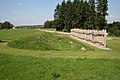
Side view with palisade, wall and moat

The Schlössle, view from the southeast


Culture

Open air theater
In 2002 a group of amateur actors came together in the Mainhardt Forest and since then has been performing the story of the robbers of the Mainhardt Forest in the open air at original locations in the municipality of Mainhardt . The venue is currently the Gögelhof near Ammertsweiler, where the “robber cave” of the historical criminal gang was in the 18th century. The piece is shown several times in the summer months.
music
In the area of the municipality of Mainhardt there is the Musikverein Gailsbach, the Musikverein Mainhardt and several choral societies.
Museums
In Mainhardt there is a Roman Museum in which finds from Roman times are shown.
The Pahl Museum is located in the Gailsbach suburb . Oil paintings and graphics by the painter and architect Manfred Pahl , who built the building with his own resources between 1975 and 1983, as well as works by his wife Aenne Pahl are shown .
Economy and Infrastructure
traffic
The federal highway 14 , which meets the federal highway 39 , as well as the state road L 1050 runs through the municipality. The next motorway connection is junction 40 (Öhringen) of the federal motorway 6 about 20 km away via the L 1050.
The Public transport is by the Heilbronner Hohenloher Haller transport ensured.
The nearest train stations are in Öhringen , approx. 20 km via the L 1050 and Bretzfeld approx. 16 km via the L 1090 on the Crailsheim – Heilbronn line .
Long-distance cycle routes
The German Limes Cycle Route runs through the community . It follows the Upper German-Raetian Limes over 818 km from Bad Hönningen on the Rhine to Regensburg on the Danube .
Long-distance hiking trails
Mainhardt is crossed by the Limes hiking trail of the Swabian Alb Association , a section of the German Limes hiking trail .
Public facilities

- Mineral swimming pool
- Gym and festival hall
- Mainhardter Forest Hall
- Bubenorbis community center (former school)
- Helmut Heinzel Hall Geißelhardt
- Village community center huts
education
- Helmut Rau School (elementary, secondary and secondary school)
Personalities
Honorary citizen
- Helmuth Heinzel (1921–2012), long-time mayor of Geißelhardt (1948–1972) and Bubenorbis (1954–1972), then full-time mayor (awarded 1986)
- Karl-Heinz Hedrich, Mayor of Mainhardts 1986 to 2010 (awarded on the occasion of his adoption on April 12, 2010)
Sons and daughters of the church
- Robert Scholl (born April 13, 1891 in the Steinbrück district (formerly Geißelhardt municipality); † October 25, 1973 in Stuttgart ), father of the Scholl siblings
- Hermann Simon (chemist) (born October 30, 1900 in Mainhardt; † September 8, 1978 in Stafford ), German-British chemist and entrepreneur
People who worked on site
- Willi Gayler (1906-2001) was head of the Mönchsberg State Forestry Office from 1948 to 1971
Web links
- ditto of Hütten in the description of the Oberamt Gaildorf from 1852.
- Map of the municipality of Mainhardt on: State Institute for the Environment Baden-Württemberg (LUBW) ( information )
- Map of the village of Mainhardt on: Geoportal Baden-Württemberg ( information )
Individual evidence
- ↑ State Statistical Office Baden-Württemberg - Population by nationality and gender on December 31, 2018 (CSV file) ( help on this ).
- ↑ Natural areas of Baden-Württemberg . State Institute for the Environment, Measurements and Nature Conservation Baden-Württemberg, Stuttgart 2009.
-
^ The work Das Land Baden-Württemberg. Official description by district and municipality. Volume IV: Stuttgart district, Franconian and East Württemberg regional associations. Kohlhammer, Stuttgart 1980, ISBN 3-17-005708-1 . Pp. 406–558 as well as supplements and corrections in Vol. VIII, Stuttgart 1983, ISBN 3-17-008113-6 , pp. 663ff., Only names one place of this name, but there are two , according to the official one
- Topographic map 1: 25,000 Baden-Württemberg, sheet no. 6923 Sulzbach an der Murr, online on this map section from the State Institute for the Environment Baden-Württemberg (LUBW) ( information ) with selected background layer topographic map
- ↑ About one kilometer south of Bubenorbis lies the Gewann Mühlwald on the right slope of the Rötenbach valley , between this and the sewage treatment plant of the village located above in the valley, which is accessed by the Mühlstraße , there are some ponds.
- ↑ The topographic map 1: 25,000 has an entry formerly Veitlenshof about 200 m west of Steinbrück.
- ↑ At the confluence of the Kimmelsbach in the Fichtenberger Rot. Remnants of stone and a board at the site.
- ↑ The topographic map 1: 25,000 has an entry Pumphof opposite the junction of the access road to Bäumlesfeld from the K 1050 Stock – Hütten .
- ^ According to topographic map 1:25 000. Sheet 6923 Sulzbach an der Murr. 9th edition. State survey office Baden-Württemberg, Stuttgart 2006, ISBN 3-89021-072-4 .
- ↑ Community structure according to the state of Baden-Württemberg. Official description by district and municipality. Volume IV: Stuttgart district, Franconian and East Württemberg regional associations. Kohlhammer, Stuttgart 1980, ISBN 3-17-005708-1 , pp. 502-506.
- ↑ State Statistical Office, area since 1988 according to actual use for Mainhardt.
- ↑ Dietwulf Baatz: The Roman Limes. Archaeological excursions between the Main and the Danube . Berlin, Gebr. Mann, 4th edition 2000, p. 238.
- ↑ Fort Mainhardt German Limeskommission.de.
- ^ Horst Clauss: The small fort Mainhardt-Ost. In: Württembergisch Franken. Yearbook of the Historical Association for Württembergisch Franken 72 , 1988. pp. 355–360; here: pp. 355–356.
- ↑ Mittelsteinzeit & Römer ( Memento of the original from March 31, 2009 in the Internet Archive ) Info: The archive link was inserted automatically and has not yet been checked. Please check the original and archive link according to the instructions and then remove this notice. on mainhardt.de.
- ↑ Römer & Limes ( Memento of the original dated December 30, 2011 in the Internet Archive ) Info: The archive link was inserted automatically and has not yet been checked. Please check the original and archive link according to the instructions and then remove this notice. on mainhardt.de.
- ↑ Mainhardt in the Middle Ages ( Memento of the original from March 31, 2009 in the Internet Archive ) Info: The archive link was inserted automatically and has not yet been checked. Please check the original and archive link according to the instructions and then remove this notice. on mainhardt.de.
- ↑ Rebels and robbers in the Mainhardt Forest ( memento of the original from November 3, 2014 in the Internet Archive ) Info: The archive link was automatically inserted and not yet checked. Please check the original and archive link according to the instructions and then remove this notice. on schwaebischhall.de.
- ↑ Modern Times ( Memento of the original from March 31, 2009 in the Internet Archive ) Info: The archive link was inserted automatically and has not yet been checked. Please check the original and archive link according to the instructions and then remove this notice. on mainhardt.de.
- ^ Federal Statistical Office (ed.): Historical municipality directory for the Federal Republic of Germany. Name, border and key number changes in municipalities, counties and administrative districts from May 27, 1970 to December 31, 1982 . W. Kohlhammer, Stuttgart / Mainz 1983, ISBN 3-17-003263-1 , p. 456 f. and 467 .
- ↑ Damian Komor - very personally at damian-komor.de (accessed on February 19, 2016)
- ↑ https://www.swp.de/suedwesten/staedte/schwaebisch-hall/damian-komor-holt-sich-97_3-prozent-24668854.html
- ↑ Results for the local elections in Mainhardt for the election on May 27, 2019
- ↑ Local election data 2014 of the State Statistical Office ( page no longer available , search in web archives ) Info: The link was automatically marked as defective. Please check the link according to the instructions and then remove this notice.
- ↑ Heinz Bardua: The district and community coats of arms in the Stuttgart administrative region . Theiss, Stuttgart 1987, ISBN 3-8062-0801-8 (district and municipality coat of arms in Baden-Württemberg, 1), p. 96.
- ↑ Maria Krönung Chapel Limesprojekt.de.
- ↑ Dietwulf Baatz: The Roman Limes. 4th edition. Gebrüder Mann, Berlin 2000, ISBN 3-7861-2347-0 , p. 238f.
- ↑ Open-air play: "The robbers from the Mainhardter Forest" .
- ↑ Gailsbacher Musik ( Memento of the original from May 11, 2013 in the Internet Archive ) Info: The archive link was inserted automatically and has not yet been checked. Please check the original and archive link according to the instructions and then remove this notice. .
- ^ Mainhardt Music Association .
- ↑ Mainhardt honorary citizen Helmuth Heinzel dies . In: Haller Tagblatt . February 27, 2012 ( from hallertagblatt.de [accessed on February 27, 2012]).

Blaufelden | Braunsbach | Bühlertann | Bühlerzell | Crailsheim | Fichtenau | Fichtenberg | Frankenhardt | Gaildorf | Gerabronn | Ilshofen | Kirchberg an der Jagst | Kreßberg | Langenburg | Mainhardt | Michelbach an der Bilz | Michelfeld | Oberrot | Obersontheim | Rose garden | Red at the lake | Satteldorf | Schrozberg | Schwäbisch Hall | Stimpfach | Sulzbach-Laufen | Untermünkheim | Vellberg | Wallhausen | Wolpertshausen