
Stork nest
|
Stork nest
Mainhardt municipality
Coordinates: 49 ° 6 ′ 54 ″ N , 9 ° 34 ′ 36 ″ E
|
|
|---|---|
| Height : | 472 m above sea level NHN |
| Postal code : | 74535 |
| Area code : | 07903 |
 Stork nest
|
|
Storchsnest is a small hamlet in the Swabian-Franconian Forest , a residential area in the village of Geißelhardt, which used to be an independent municipality and was incorporated into the municipality of Mainhardt as part of the municipality reform on January 1, 1972 .
The place is in the middle of forests and small fields on the northern edge of the Mainhardt Forest . To the northwest there is a view of the Ohrntal valley with its steep vineyards and beyond to the mountain ranges of the Odenwald . The Frankenweg , main hiking trail 8 of the Swabian Alb Association , leads through the village.
Storchsnest is built entirely on the Ohrntal side of Dorfstrasse, so all properties are in one row ( Reihendorf ). This street is probably older than the settlement itself. Its course, still traceable today, to the Landturm near Michelfeld and its connection at the Steigenhaus to the Rote Steige in the east, as well as the course over Frohnfalls through the former rule of Gleichen in the west to the lower Ohrntal make the assumption suggests that it could have been the old salt road from Hall to Heilbronn .
The main occupation of the residents was agriculture and forestry until the mid-1970s. These are now only operated as a sideline , and the population commutes.
Many of the former residents are overseas emigrated , so that maintained in almost every home relationships in the United States or Canada. The reasons for the rural exodus to the surrounding cities and for the emigration were the high population pressure due to the large number of children, the rather meager income on the less fertile heights of the Keuper Hills , and last but not least the inheritance law that applies here, as everywhere in Hohenlohe , according to which one child has The entire farm belonged to the family .
The place was probably created by the first settlers from the Ohrntal around 1570. The traditional dialect that is spoken here is a form of Hohenlohe that is now slowly being displaced by the spreading south-west German colloquial language of High Swabian.
There are various legends about the origin of the very peculiar place name , but there is no evidence as to where the name could really come from. It does not appear anywhere else in German-speaking countries .

Stork's nest near Geißelhardt
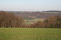
View from Storchsnest to Büchelberg

Stork's nest seen from Hausenbühl


Individual evidence
- ^ Federal Statistical Office (ed.): Historical municipality directory for the Federal Republic of Germany. Name, border and key number changes in municipalities, counties and administrative districts from May 27, 1970 to December 31, 1982 . W. Kohlhammer, Stuttgart / Mainz 1983, ISBN 3-17-003263-1 , p. 456 .