
Eltershofen
|
Eltershofen
City of Schwäbisch Hall
|
|
|---|---|
 |
|
| Height : | 397 m |
| Area : | 5.42 km² |
| Residents : | 669 (Dec. 31, 2012) |
| Population density : | 123 inhabitants / km² |
| Incorporation : | July 1, 1973 |
| Postal code : | 74523 |
| Area code : | 0791 |
 Districts of Schwäbisch Hall, Eltershofen in the north
|
|
 Church in Eltershofen 2010
(formerly the chapel of St. Magdalena) |
|
Eltershofen is a district of Schwäbisch Hall in the district of the same name in northeastern Baden-Württemberg .
geography
The eponymous main town of the formerly independent municipality is located about 4 kilometers northeast of the city center of Schwäbisch Hall on the slightly hilly northern Haller level between the deeply cut valleys of the Kocher in the west and northwest and the Bühler further in the northeast. The small clustered village is characterized by agriculture. The short stream Diebach zum Kocher arises a little south of the village and crosses it in a fairly flat course, before it soon drops steeply to the Kocher through the oil blade after passing the local moated castle on the northern edge of the village . There are meadows and many fields around the soft surface, and there is only some distance to the forest on the slopes of the Kocher valley and in the Ölklinge. An access road runs through the village in a left-hand bend from the L 2218 in the south (old route of the B 14 in the direction of Crailsheim ) to the Haller east bypass in the west.
The district includes the independent suburb of Breitenstein . It lies on the slightly sloping edge of the plateau, almost on the edge of the slope to the Kocher valley near the sources of the Eltershofer Bach . A little before 1970, the still independent communities of Eltershofen, Weckrieden and Gelbingen built the so-called EEC school, a joint elementary and secondary school, on the green meadow and in the geographical center between the three places. A few years later, in the early 1970s, a residential area made up of one and two-family houses was built around the school.
history
Eltershofen was first mentioned in 1248 in connection with a legal dispute between the Haller Johanniterkommende and three brothers over the local castle. In addition to the Philips-Eberhart, who, according to Eugen Gradmann, were local nobility at Eltershofen Castle as early as 1210 and later appeared as patricians as citizens of Hall, other Haller bourgeois families, the Comburg monastery and the Counts of Hohenlohe were also wealthy here.
In 1516, the Philips-Eberhart family died out. The castle then came into the possession of the Nagel family from Hall, who now called themselves von Eltershofen and donated, among other things, the Eltershofen altar in St. Nikolaus . In 1536 a large part of the town burned down. 14 buildings were destroyed by this fire. Also in the 16th century, the imperial city of Hall acquired most of the village and thus took over the manorial rights over the place. As a result, the community became part of the Haller land territory and was subordinate to the Halle office (In der) Schlicht .
During the Thirty Years War , Eltershofen was devastated again in 1645 by a village fire. This time 23 buildings fell victim to the flames. In the second half of the 17th century, wealthy citizens of Hall rebuilt the castle into a representative country house, today's castle.
According to Gradmann, the current village church was rebuilt in 1769, probably on parts of a previous building, a chapel dedicated to St. Magdalena.
After the imperial city was dissolved and the Hall territories were taken over by Württemberg in 1802, the community belonged to the newly established Württemberg Oberamt Hall , from which the Hall district emerged in 1934 and the Schwäbisch Hall district in 1941.
On July 1, 1973 Eltershofen was incorporated into Schwäbisch Hall.
Attractions
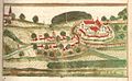
Eltershofen in a Haller Chronicle around 1600
.jpg&filetimestamp=20131230154809&)
Buildings
- Eltershofen Castle
- Eltershofen village church. Eugen Gradmann described it like this in 1907: The Protestant branch church was rebuilt in 1769, simple and unadorned. The round choir arch may still be Romanesque. In the choir a new cross vault without ribs. A roof turret as a bell tower. Altar screen from 1683 with an artless oil painting of the First Supper
Natural monument cemetery oak
⊙ Amonumentalpedunculate oakthat is at least 400 years old and is identifiedas anatural monument(ND – Nr. 81270760008)at the cemetery, 7.65 meters in circumference and 18 meters in height.
literature
- Eugen Gradmann : The art and antiquity monuments of the city and the Oberamt Schwäbisch-Hall . Paul Neff Verlag, Esslingen a. N. 1907, OCLC 31518382 ( archive.org ). .
- State of the imperial city of Halle in Swabia . In: Latest State Ads . Second volume. Mutzenbecher, 1797, ZDB -ID 525800-5 , p. 490–497 ( p. 490 in Google Book Search).
Individual evidence
- ↑ a b c http://www.schwaebischhall.de/buergerstadt/geschichte/chronik.html
- ↑ http://www.schwaebischhall.de/buergerstadt/geschichte/eltershofen.html
- ^ Entry in the directory of monumental oaks . Retrieved January 22, 2017
