Waking peace
|
Waking peace
City of Schwäbisch Hall
|
|
|---|---|
| Coordinates: 49 ° 7 ′ 19 ″ N , 9 ° 45 ′ 14 ″ E | |
| Height : | approx. 375–400 m above sea level NN |
| Area : | 3.44 km² |
| Residents : | 335 (December 31, 2012) |
| Population density : | 98 inhabitants / km² |
| Incorporation : | January 1, 1972 |
| Postal code : | 74523 |
| Area code : | 0791 |
|
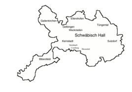
Districts of Schwäbisch Hall, Weckrieden north of the city center
|
|
|
Land map of Weckrieden 1700
|
|
Weckrieden is a district of Schwäbisch Hall in the district of the same name in northeast Baden-Württemberg .
geography
The formerly independent community of Weckrieden is located almost two kilometers northeast of the town center of Schwäbisch Hall on the Haller level , on the right, northwest slope of the Wettbach , which, after passing the small hamlet, which has now almost grown together with Schwäbisch Hall, into its steep and not very long shell limestone gorge enters the Kocher further to the west before it flows into it . The L 2218 from Hall in the direction of Crailsheim passes close by, the old route of the B 14 , which also opens it up. Weckrieden shows a still very rural aspect with many orchards in the soft area and has its own small cemetery on the hillside, from where there is a broad view over the downward Kocher valley towards Gailenkirchen and the Waldenburg mountains rising behind .
history
The area of the place was already settled in the Neolithic Age. Several settlements from that time are proven on the district.
Weckrieden was first mentioned in 1296 in a deed of sale by three brothers from the von Vellberg family , in which a knight Ulrich von Weckrieden was named as a witness. In addition to the citizens of Hall, Limpurg's taverns also had rulership rights over the place .
Towards the end of the 16th century, the imperial city of Hall had acquired most of the village's goods and was able to exercise lordship over the place. As a result, Weckrieden became part of the Haller land territory and was subordinate to the Halle office (In der) Schlicht .
After the dissolution of the imperial city and the takeover of the Haller rural areas by Württemberg in 1802, the community belonged to the newly founded Württemberg Oberamt Hall , from which the district of Hall emerged in 1934 and the district of Schwäbisch Hall in 1941.
In 1849 the area of the community Weckrieden was reduced considerably and only reduced to the boundary of the main town. The previous suburbs of Altenhausen , Ramsbach , Veinau and Wolpertsdorf have been changed from Weckrieden to Tüngental . Bühlerzimmer came to the community of Geislingen .
On January 1, 1972, Weckrieden was incorporated into the city of Schwäbisch Hall.
literature
- State of the imperial city of Halle in Swabia . In: Latest State Ads . Second volume. Mutzenbecher, 1797, ZDB -ID 525800-5 , p. 490–497 ( p. 490 in Google Book Search).
Individual evidence
- ↑ http://www.schwaebischhall.de/buergerstadt/geschichte/chronik.html
- ↑ http://www.schwaebischhall.de/buergerstadt/geschichte/weckrieden.html
- ^ Federal Statistical Office (ed.): Historical municipality directory for the Federal Republic of Germany. Name, border and key number changes in municipalities, counties and administrative districts from May 27, 1970 to December 31, 1982 . W. Kohlhammer, Stuttgart / Mainz 1983, ISBN 3-17-003263-1 , p. 456 .
Web links
- Wikisource: Weckrieden in the description of the Oberamt Hall from 1847
- Map of Weckrieden on: State Institute for the Environment Baden-Württemberg (LUBW) ( Notes )


