
City center (Schwäbisch Hall)
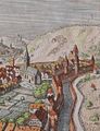
Schwäbisch Hall-Stadtmitte is the central district of Schwäbisch Hall and has 2543 inhabitants (as of 2012). The district includes the medieval city center on the right slope of the Kocher valley and in its valley, the medieval city extensions Katharinenvorstadt (to the left of the Kocher) and Gelbinger Vorstadt (north of the old town along the Gelbinger Straße), the Weilerwiese opposite this and the Vorderen Galgenberg east of the former city wall .
City center
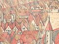
The city center developed around the church of St. Michael . Most of the old buildings burned down in 1728; In the east, around the two Herrengassen and even smaller streets, the old townscape has been preserved with streets narrowing towards the top due to the higher floors of buildings.

Schwäbisch Hall, St. Michael and City Hall.

Schwäbisch Hall. The great city fire of 1728 destroyed most of today's old town.

Schwäbisch Hall after the fire, etching by A. Nunzer, Nuremberg, after a drawing by Johann Philipp Meyer, Hall, 1728.


Gelbinger suburb
The Gelbinger Vorstadt was the second large-scale urban expansion of the city of Schwäbisch Hall in the 14th century. The Gelbinger suburb was not walled until the middle of the 14th century. On June 3, 1680, a lightning strike triggered a major fire in Gelbinger Gasse, which killed around 100 buildings. The Gelbinger Gasse remained unscathed by the great fire of 1728. This suburb is located in front of the old Gelbinger Tor in the old town and stretches along the old country road down the valley on a land platform at a distance of no more than 200, often less, meters to the right of the Kocherufer. It ends in the north at the Äußere Gelbinger Tor, which was removed in 1807. At St. Jodokus (also Josenkapelle ) (Gelbinger Gasse 39) on the western flank of the northward stretch of the city district stands the popular Josenturm with a small valley gate, through which a steep alley through the Zwinger leads down to the river bank, where there were once three mills. The Lange Graben stretches along the east side in front of the only partially preserved city wall. On the southern side, the Keltersthürlein went onto the begging path that leads to the Galgenberg. At the southeast corner there was once a rounded bastion tower on which a half-timbered structure sits today. The Gräterhaus is located at Gelbinger Gasse 47, opposite the high flight of stairs of the district administration office, which was built in the second half of the 20th century and whose stone-faced east facade imitates the former wall against the Lange Graben.

Schwäbisch Hall, Gelbinger Gasse, detail from the city view by Matthäus Merian based on a model by Leonhard Kern, 1643, with the previous development of the area before the fire in Gelbinger Gasse from 1680 (StadtA SHA S10-506)
Schwäbisch Hall, fire in Gelbinger Gasse on June 3, 1680, colored pen drawing (StadtA SHA HV HS 068)

Schwäbisch Hall, Gelbinger Gasse, excerpt from the city map from 1816 (StadtA SHA 16-0069)

Schwäbisch Hall. In one of the biggest city fires in 1680, most of the Gelbinger Gasse was destroyed.

Schwäbisch Hall after the fire, 1680
Schwäbisch Hall. The Gelbinger Gasse remained unscathed by the great fire of 1728.

Gelbinger Gasse with the Josenturm
Gelbinger Gasse, Gräter house

Johann Friedrich Reik (1836–1904), watercolor, Gräterhaus, Gelbinger Gasse 47, Schwäbisch Hall (builders Albrecht Frank and Franz Greter), home of Leonhard Kern (1621–1628).
.jpg&filetimestamp=20140109064436&)
.jpg&filetimestamp=20140109064427&)
.jpg&filetimestamp=20140109064423&)


.jpg&filetimestamp=20140109130450&)


,_Aquarell,_Gr%C3%A4terhaus,_Gelbinger_Gasse_47,_Schw%C3%A4bisch_Hall_(Bauherren_Albrecht_Frank_und_Franz_Greter),_Wohnhaus_von_Leonhard_Kern_(1621-1628).jpg)
Katharinenvorstadt
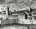
The Katharinenvorstadt was the third extension of Hall in the 14th century. The buildings were built in rows along the edge of the slope on the southern bank of the Kocher. The Katharinenvorstadt was not walled until the middle of the 14th century. It is located on the left side of the Kocher near St. Katharina and had two street gates, the Weilertor to the north, Gottwollshausen to and the Riedener Tor to the south. The Riedener Tor was demolished in 1824. From the Riedener Tor there were several platforms . The Riedener Tor was only moved to its later location in 1490. Before that, the south gate of the Katharinenvorstadt was further up on the valley slope, at the southwest corner of the Katharinenvorstadt, where the Lange Gasse, parallel to the Kocher, and the Zollhüttengasse, which leads up from it, converge. In place of the former south gate of the Katharinenvorstadt a gun turret was built in 1490, later named "Powder Tower" (probably because of its use as a flour store). The bulwark was started in 1490 and enclosed the mountain side of the Katharinenvorstadt. The bulwark consisted of the large and small bulwark. The great bulwark was at St. Katharinen. The small bulwark was at the hamlet.
Schwäbisch Hall, Katharinenvorstadt.

The Mauerstrasse of the medieval suburb "Jenseits Kochens", upstream from the Henkersbrücke

Riedener Tor, copper engraving from the 18th century (StadtA SHA FS 45195).

The Henkersbrücke with a view towards "Neue Straße"


.jpg&filetimestamp=20140109064419&)

Weilerwiese
The city fortifications with the hamlet gate are located in the hamlet suburb. The small bulwark from 1490 was also located at the hamlet. The hamlet gate (Heubertor in the 14th century) was built in 1579 from stone. At first the tower was open at the rear. The imperial city double coat of arms is on the tower.

Individual evidence
- ↑ a b Eugen Gradmann : The art and antiquity monuments of the city and the Oberamt Schwäbisch-Hall . Paul Neff Verlag, Esslingen a. N. 1907, OCLC 31518382 , pp. 59-60 ( archive.org ).
- ↑ http://www2.mvi.baden-wuerttemberg.de/servlet/is/103787/
- ↑ http://www.schwaebischhall.de/buergerstadt/geschichte/haeuserlexikon/gebaeudeververzeichnis.html?Detail=385
- ^ Eugen Gradmann : The art and antiquity monuments of the city and the Oberamt Schwäbisch-Hall . Paul Neff Verlag, Esslingen a. N. 1907, OCLC 31518382 , pp. 63 ( archive.org ).
- ^ Eugen Gradmann : The art and antiquity monuments of the city and the Oberamt Schwäbisch-Hall . Paul Neff Verlag, Esslingen a. N. 1907, OCLC 31518382 , pp. 62-63 ( archive.org ).
Web links
- Map of Schwäbisch Hall city center on: State Institute for the Environment Baden-Württemberg (LUBW) ( information )
- List of sub-locations on the website of the city of Schwäbisch Hall

Coordinates: 49 ° 7 ' N , 9 ° 44' E