
Gelbingen
|
Gelbingen
City of Schwäbisch Hall
|
|
|---|---|
 |
|
| Height : | 282 m |
| Area : | 3.59 km² |
| Residents : | 770 (December 31, 2012) |
| Population density : | 214 inhabitants / km² |
| Incorporation : | 1st January 1975 |
| Postal code : | 74523 |
| Area code : | 0791 |
 Districts of Schwäbisch Hall, Gelbingen north of the city center
|
|
Gelbingen is a district of Schwäbisch Hall in the district of the same name in northeast Baden-Württemberg .
geography
The eponymous capital of the formerly independent municipality is located downstream and about two and a half kilometers north-northeast of the core town of Schwäbisch Hall, also on the right bank of the Kocher . The core of the settlement was built on the cone of rubble that was safe from flooding and that the Eltershofer Bach , flowing down from Breitenstein , had accumulated in its mouth. At the level of Gelbingen the river itself begins to form a two and a half kilometer long west loop. The Umlaufberg in its middle, called Neuberg , carried the defunct Neuburg Castle , which, according to Gradmann, was an aristocratic seat of the von Eltershofen family. The B 19 runs through Gelbingen from the center of Hall northwards in the direction of Untermünkheim , shortening the loop of the river by making an incision in the Neuberg neck. To the left of the river bend on the other side of the Neubergs, the Geyersburg once stood on the boundary of Untermünkheim , from which the remains of a polygonal tower have survived.
The district also includes a noticeably smaller suburb of Erlach , a hamlet with agriculture and only a dozen house numbers, which is a further kilometer north-northeast of Hall city center on the plateau to the right above the shoulder of the downstream Kocher valley a good 100 meters higher.
history
In 1248, Gelbingen was first mentioned in connection with the possessions of the Comburg monastery. The taverns of Limpurg and Haller bourgeois families were also wealthy here at that time. The von Eltershofen family donated the St. Johannes chapel in 1342 , from which the later parish church of the Protestant parish emerged. Until the Reformation , Gelbingen was a church branch of Erlach. In the 15th and 16th centuries, the village was gradually incorporated into the territory of the imperial city of Hall , which took over all manorial rights over the place. The rural community was subordinate to the Hällischen Amt (In der) Schlicht . Intensive viticulture was practiced here until the 18th century, as evidenced by the ruins of several wine presses; the accessible walls one of them stands behind the Neuberg on the edge of the wide Kocheraue. After the imperial city was dissolved and the Hall territories were taken over by Württemberg in 1802, the community belonged to the newly established Württemberg Oberamt Hall , from which the Hall district emerged in 1934 and the Schwäbisch Hall district in 1941. In 1945, Gelbingen suffered severe damage from the Second World War . On January 1, 1975 it was incorporated into the city of Schwäbisch Hall.

The town hall of Gelbingen on the B 19
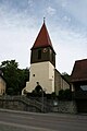
The Protestant Church in Gelbingen
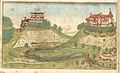
Gelbingen bottom right with Neu (en) burg and Geyersburg , from right to left. Distorted representation around 1600.


_mit_Neuenburg_und_Geyersburg.jpg&filetimestamp=20131230203749&)
literature
- Eugen Gradmann : The art and antiquity monuments of the city and the Oberamt Schwäbisch-Hall . Paul Neff Verlag, Esslingen a. N. 1907, OCLC 31518382 , pp. 98-99 ( archive.org ).
- State of the imperial city of Halle in Swabia . In: Latest State Ads . Second volume. Mutzenbecher, 1797, ZDB -ID 525800-5 , p. 490–497 ( p. 490 in Google Book Search).
- Topographic map 1: 25,000 Baden-Württemberg, as single sheet No. 6824 Schwäbisch Hall
Individual evidence
- ^ Federal Statistical Office (ed.): Historical municipality directory for the Federal Republic of Germany. Name, border and key number changes in municipalities, counties and administrative districts from May 27, 1970 to December 31, 1982 . W. Kohlhammer, Stuttgart / Mainz 1983, ISBN 3-17-003263-1 , p. 468 .
- ↑ http://www.schwaebischhall.de/buergerstadt/geschichte/gelbingen.html
Web links
- Map of Gelbingen and the surrounding area on: State Institute for the Environment Baden-Württemberg (LUBW) ( information )
- Description of Gelbingen on the page Gelbingen - Altgemeinde ~ part of the regional information system www.leo-bw.de
