
Dark red
|
Dark red
Wüstenrot municipality
|
|
|---|---|
 |
|
| Height : | 491 m above sea level NN |
| Area : | 1.91 km² |
| Residents : | 503 (2009) |
| Population density : | 263 inhabitants / km² |
| Incorporation : | 1st January 1974 |
| Area code : | 07945 |

Finsterrot is a place and a formerly independent municipality that was merged in 1974 with the neighboring municipalities of Maienfels , Neuhütten and Wüstenrot to form the new unitary municipality of Wüstenrot in the Heilbronn district in northeastern Baden-Württemberg . The place was probably built around 1500 as a clearing settlement near a glassworks and today has around 500 inhabitants.
geography
Finsterrot, the easternmost of the five Wüstenrot districts, is located in the natural area of the Swabian-Franconian Forest Mountains at around 491 m above sea level. NN , about 1 km north of the confluence of the Dachsbach in the Kocher tributary Rot, which rises a few kilometers to the west . The demarcation, which is divided into several ridges and valley cuts, did not permit closed development, so that Finsterrot consists of several residential areas close together.
The main town is on the western slope of the Dachsbach valley and, to a lesser extent, on the adjacent plateau. Further north is the Finsterroter See , originally dammed up in the Dachsbachtal as Mühlsee and now used as a swimming and fishing lake , one of several lakes in the Finsterroter area. South of the main town, two smaller brooks flow to the Dachsbach from the west and separate two ridges. The Binsenhöfle residential area is on the southern of these two ridges, bounded by the Rottal in the south , and the Berg residential area on the north . Another residential area called Dörfle is located further to the west at the point where both ridges meet and run out in a plain. After the Second World War, Berg and Dörfle were connected by a new building area. Two single farmsteads on the southern ridge and a former grinding mill in the lower Dachsbachtal, south of the main town, also belong to Finsterrot.


The valleys of the Rot and the lower Dachsbach on the Finsterroter area have been a nature reserve since 1991 . A reed area of around 1.5 hectares north of the Finsterroter See has also been protected as an extensive natural monument since 1986 .
The area of the former municipality is relatively small with an area of 191 hectares . The forest that used to cover the area has been cleared over the centuries with the exception of a few remains. Because of the barren soil, arable farming plays a subordinate role, so that the area today consists largely of grassland .
Finsterrot is on federal highway 39 , which connects Heilbronn with Schwäbisch Hall in a west-east direction . The road used to go directly through the main town, but in 1853 it was moved to a slightly less steep route on its west side. The neighboring places on the B 39 in the east are the village of Ammertsweiler , which belongs to the municipality of Mainhardt in the Schwäbisch Hall district , and the hamlet of Weihenbronn, which belongs to Wüstenrot, to the west . In Weihenbronn, the provincial road 1090 crosses the B 39 and leads in the south to the main town of Wüstenrot, which gives the municipality its name, and in the north to Neuhütten , both of which are also neighboring towns of Finsterrot. In the southeast, the Finsterroter district in the valley of the Rot also borders on the hamlet of Hals, which belongs to the municipality of Großerlach in the Rems-Murr district .
history

Finsterrot was probably created around 1500 by the Hohenlohe secretary Wendel Hipler as a clearing settlement near a glassworks . There were probably two glassworks, one in the lower Dachsbachtal between the mill and the confluence of the Dachsbach in the Rot, where field names such as Glasklinge , Glaswald and Aschenbühl still refer to the hut that used to be located here, and another further up in the Dachsbachtal, today Lower district of Finsterrot, to which glass finds made during construction work in 1935 and 1963 indicate. A glass pot found there decorates the new coat of arms of the municipality of Wüstenrot, awarded in 1975. Hipler held the place as a fiefdom of the Counts of Hohenlohe and called it Fischbach , as his seal from 1507 with two fish in the brook and the inscription Wendel Hipler von Fischbach 1507 shows. In 1511, in a document from Count Georg and Albrecht von Hohenlohe, the settlement "on the vinstern Rodt" was mentioned for the first time, and in 1512 the "Vinsterrot".
After a long-standing legal dispute between Hiplers and the Counts of Hohenlohe and a dispute with the glassworks master Ulrich Greiner from neighboring Stangenbach, whose house Hipler had attacked in 1519, Hipler lost the local rule over Finsterrot to Greiner, who took the place in 1523 and removed it in 1528 Hohenloher Count was enfeoffed in the same way as Hipler with the goods around Finsterrot. In 1559 Greiner finally sold all of his goods and rights in the village for 3500 guilders to Count Ludwig Casimir von Hohenlohe-Neuenstein.

Until 1806 Finsterrot remained in Hohenlohe and part of the Franconian Empire , then it fell to the Kingdom of Württemberg , where it was assigned to the Oberamt Neuenstein until 1808, then to the Oberamt Öhringen until 1810 and finally to the Oberamt Weinsberg until its dissolution in 1926 . By 1809 at the latest, several surrounding settlements, including Hals, Hasenhof, Laukenmühle , Ammertsweiler, Kutzenweiler and Weihenbronn, were assigned to a mayor's shop based in Finsterrot, but they were all separated again before 1828.
Poverty and a decline in population caused by emigration, especially to the USA , shaped the 19th century in Finsterrot. In 1856 Finsterrot, like the other predecessor municipalities of today's municipality of Wüstenrot, came under direct state administration on the basis of the law on the handling of state supervision over neglected municipalities , which lasted until 1873.
After the upper office of Weinsberg was dissolved in 1926, Finsterrot, located in the border area of several administrative units since 1806, came back to the upper office of Öhringen, and finally to the district of Schwäbisch Hall during another district reform in 1938 . Skirmishes between German and American units around Reichsstrasse (today Bundesstrasse 39 ) claimed five lives at the end of World War II and destroyed 19 residential buildings and 21 barns until American troops occupied the site on April 18, 1945 after the German units withdrew.
After the war damage had been repaired by the beginning of the 1950s, building activity began and the infrastructure such as roads, water supply and sewerage was improved and expanded. New development areas ensured an increase in population and a connection between the Berg and Dörfle residential areas . The district reform of 1973 assigned Finsterrot to the district of Heilbronn in anticipation of the merger with neighboring communities to form the new community of Wüstenrot on January 1, 1974 as part of the Baden-Württemberg municipal reform .
Religions

Finsterrot initially belonged to Mainhardt. Like the rest of Hohenlohe was Finsterrot with the introduction of the Reformation in the 16th century Protestant . From 1567 at the latest until 1851 it was a branch of Wüstenrot. In that year it was resolved by Wüstenrot and, together with Neuhütten, which had been a subsidiary of Maienfels up until then, it was raised to a parish of its own. The first clergyman took up residence in Finsterrot in 1851. Since there was no church in the village, services were held in the schoolhouse. After long disputes between Finsterrot and Neuhütten about the church, pastor's seat and pastor's apartment, a ministerial decree of November 11, 1856 ordered the parish's seat to be relocated to larger Neuhütten. The Finsterroter Schulhaus, built in 1831, was converted into a prayer hall with state aid and consecrated as a Protestant church on November 15, 1857. A thorough renovation in 1957 could not prevent the building from falling apart; it was demolished in 1980 and replaced by a new building in 1981. The Protestant Church is also present through a youth camp, which is used mainly in summer and which is operated by the Weinsberg Evangelical Youth Office near the Finsterroter See.
The Catholics resident in Finsterrot have belonged to the parish ( Obersulm -) Affaltrach since 1990 , which has the St. Barbara Church in Neuhütten .
politics
Local council and mayor
In the legal sense, Finsterrot is a place within Wüstenrot with a local council that has six members. At the suggestion of the local council, the Wüstenrot municipal council elects an honorary local chief Finsterrots. These bodies are to be heard on important matters affecting the locality.
coat of arms
The blazon of the dark red coat of arms reads: In red, a silver (white) sloping waved bar, covered with two blue fish. The Finsterrots flag was white and red. The coat of arms and flag were approved on December 7, 1961.
The coat of arms goes back to a seal Wendel Hiplers with two fish in the brook, which he led after what he called Fischbach in today's Finsterrot 1507.
Buildings
The most important architectural monument of Finsterrot is the Gasthaus zum Waldhorn , a two-storey ornamental half - timbered building with a bricked basement that was built in the 17th century as a Hohenlohe customs house . With the relocation of the thoroughfare through Finsterrot in 1853, the main entrance of the inn was also relocated from the north to the south side of the new road. The original main entrance with a porch supported on wooden columns over a double-armed flight of stairs has since been located on the back of the building on Alte Straße . Diagonally across from the Waldhorn is a stone gallows well from 1731 with the coat of arms of the von Olnhausen family on top of a round stone trough.
The Finsterroter Friedhof is located on the southern ridge towards the Rottal, between the Binsenhof residential area in the west and a single farm in the east. It was laid out in 1676 and is partially bounded by an old sandstone block wall in the north and east. The old entrance in the east consists of a high segment arch.
The Protestant church with a conspicuous, separately standing small wooden bell tower was built in 1981 in place of a prayer house from 1831/1857 that was demolished in 1980 (built in 1831 as a school and town hall, converted into a prayer house in 1857). Two glass windows from 1957 and a bell made by Johann Georg Lösch from Morsbach in 1783 were taken over from the previous building. On April 18, 2002, a fire destroyed the bell tower, which was restored to its original state in 2003. The bell from 1783, damaged in the fire, has been standing next to the tower ever since.

Gasthaus Waldhorn (north side)

Gasthaus Waldhorn (south side)

Fountain from 1731
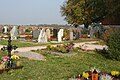
graveyard

Damaged bell from 1783


Personalities
- Karl Hermann (born June 21, 1888 in Finsterrot; † December 25, 1961 in Möckmühl), pedagogue and local researcher
Individual evidence
- ↑ Nature reserve No. 1.178, meadows in the Rot- and Dachsbachtal near Finsterrot , protected since April 16, 1991, profile from the State Institute for Environmental Protection, Measurements and Nature Conservation Baden-Württemberg
- ↑ Extensive natural monument no. 81251070007, wetland near Finsterroter See , protected since July 18, 1986; Profile at the State Institute for Environmental Protection, Measurements and Nature Conservation Baden-Württemberg
-
↑ Additional sources for the geography section: Topographic map 1:25 000. Sheet 6922 Wüstenrot . 8th edition. Landesvermessungsamt Baden-Württemberg, Stuttgart 2001, ISBN 3-89021-071-6 and topographic map 1:25 000. Sheet 6923 Sulzbach an der Murr . 9th edition. Landesvermessungsamt Baden-Württemberg, Stuttgart 2006, ISBN 3-89021-072-4
The state of Baden-Württemberg. Official description by district and municipality. Volume II: The municipalities before and after the territorial reform. Basic regional statistical data. Kohlhammer, Stuttgart 1975, ISBN 3-17-002349-7 , p. 135
The state of Baden-Württemberg. Official description by district and municipality. Volume IV: Stuttgart district, Franconian and East Württemberg regional associations. Kohlhammer, Stuttgart 1980, ISBN 3-17-005708-1 , pp. 150-153 - ^ Federal Statistical Office (ed.): Historical municipality directory for the Federal Republic of Germany. Name, border and key number changes in municipalities, counties and administrative districts from May 27, 1970 to December 31, 1982 . W. Kohlhammer, Stuttgart / Mainz 1983, ISBN 3-17-003263-1 , p. 451 .
- ↑ Common Official Gazette of the State of Baden-Württemberg 10.1962, p. 129
-
↑ Source for the section buildings: Christoph Seeger: Catalog of architectural monuments in Wüstenrot. In: Wüstenrot. History of a community in the Swabian-Franconian Forest. (see literature), pp. 231–244
Peter Hecht: The church of Finsterrot. In: Evangelical churches in the deanery Weinsberg. Evangelical Dean's Office Weinsberg, Weinsberg 2003, pp. 16-17
literature
- Karl Siller: Dark red. In: Wüstenroter Heimatbuch . Municipal administration Wüstenrot, Wüstenrot 1979, pp. 9–28
- Desert red. History of a community in the Swabian-Franconian Forest. Municipality of Wüstenrot, Wüstenrot 1999, ISBN 3-00-005408-1 ( Municipality in transition. Volume 8)