
Murter (Surses)
| Murter | ||
|---|---|---|
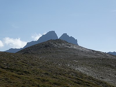
 Alp Schmorras, in the background the Murter ridge from Piz Mez (left) to P. 2752 (right). |
||
| height | 2752 m above sea level M. | |
| location | Canton of Graubünden , Switzerland | |
| Mountains | Oberhalbsteiner Alps | |
| Dominance | 1.626 km → Piz Cagniel | |
| Notch height | 136 m ↓ Fuorcla da Saletscha | |
| Coordinates | 759.59 thousand / 153860 | |
|
||
 Steinmann and summit book on the highest point of Murter |
||

The Murter ( Rhaeto-Romanic , from Latin mortarium , mortar, high alpine pasture, especially sheep pasture ) is an elongated ridge south of the Savognin ski area in the canton of Graubünden in Switzerland . The ridge separates the Val Curtegns from the Val Schmorras . Its northern corner point is the Piz Mez ( 2718 m above sea level ). The culmination is in the southern part of the ridge and is 2752 m above sea level. M. The proximity to ski it is an easy-to-reach mountain ski tours.
Location and surroundings

The Murter is a degree whose northern corner point is the Piz Mez ( 2718 m above sea level ) and whose culmination is 2752 m above sea level. M. is in the south. It is bordered in the west by the Val Schmorras and in the east by the Val Curtegns, two side valleys of the Val Nandro . The ridge becomes rocky to the south and is covered with coarse layer heads that slope steeply to the south.
The Murter belongs to the Piz Grisch group , a sub -group of the Oberhalbsteiner Alps . The ridge is located on the municipal area of Surses , but at the culmination the municipal boundary with Ferrera runs .
The neighboring peaks include Piz Arlos , Piz Arblatsch , Piz Forbesch , Piz Cagniel , Piz Alv , Piz Settember , Sur Carungas , Piz Cartas and Piz Martegnas .
The most distant visible point ( 46 ° 1 ′ 34.9 ″ N , 7 ° 53 ′ 7.1 ″ E ) from the culmination point of the Murter is 370 m north of the Rimpfischhorn , east of Zermatt in the Valais Alps , and is 136 , 9 km away.
Valley locations are Riom, Parsonz and Savognin. A common starting point is radon.
Routes to the summit
An ascent of the ridge (more from south to north) is possible, but time-consuming. A trail marked as a white-red-white hiking trail passes 50 m south of the culmination:
Over the southeast ridge

- Starting point: Radons ( 1893 m ) or Innerferrera ( 1480 m )
- Via: Fuorcla Starlera ( 2512 m )
- From radons through the Val Curtegns to Fuorcla Starlera
- From Innerferrera via Starlera ( 1782 m ), Alp Starlera ( 2078 m ), Pass Mal, Alp Sura ( 2276 m ) to Fuorcla Starlera
- Difficulty: EB , marked as a white-red-white hiking trail .
- Time required: ¾ hours from the Starlera pass
- 3 hours from radons
- 4¼ hours from Innerferrera
Over the west ridge

- Starting point: Radons ( 1893 m ) or Innerferrera ( 1480 m )
- Via:
- From Radons via Alp Schmorras ( 2274 m ), Lai da Schmorras ( 2291 m ) to almost Fuorcla da Saletscha, but first head south and reach the ridge at P. 2638.
- From Innerferrera follow the path to Fuorcla Starlera to beyond the Mal pass, and then north up the slope. Instead of going to Fuorcla da Saletscha, you can turn northeast to reach the ridge at P. 2638.
- Difficulty:
- EB , a hiking trail white-red-white marks
- EB / BG
- Time required:
- 3½ hours from radons
- 4½ hours from Innerferrera
panorama

gallery

The whole ridge of the Murter (with Piz Mez on the left and the culmination on the right), taken from Alp Schmorras .

The culmination, recorded from Alp Schmorras.
The culmination, in the background the Piz Forbesch.

View from the culmination over the whole ridge of the Murter. At the very end is the Piz Mez.


literature
- Manfred Hunziker: Club guide, Bündner Alps . Obverse. 1st edition. tape III . Verlag des SAC, 1994, ISBN 3-85902-140-0 , p. 274 .
- National map of Switzerland, sheet 1255 Splügenpass, 1: 25,000, Federal Office of Topography, 2012 edition.
- National map of Switzerland, sheet 1256 Bivio, 1: 25,000, Federal Office of Topography, 2015 edition.
Web links
Individual evidence
- ↑ Andrea Schorta: How the mountain got its name . Small Rhaetian name book with two and a half thousand geographical names of Graubünden. Terra Grischuna Verlag, Chur and Bottmingen / Basel 1988, ISBN 3-7298-1047-2 , p. 108 .
- ↑ Calculated 360 ° panorama ( U. Deuschle ; information ) from Murter