
Lai da Schmorras
| Lai da Schmorras | ||
|---|---|---|

|
||
| Geographical location | Canton of Graubünden , Switzerland | |
| Drain | Ava da Schmorras → Ava da Nandro → Schletg → Gelgia | |
| Location close to the shore | Savognin | |
| Data | ||
| Coordinates | 759 003 / 156273 | |
|
||
| Altitude above sea level | 2291 m above sea level M. | |
| surface | 0.177 1 ha | |
| length | 68 m | |
| width | 46 m | |
| scope | 168 m | |

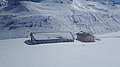
The Lai da Schmorras is a mountain lake in the Val Schmorras , above Radons near Savognin in the municipality of Surses in the canton of Graubünden in the Swiss Alps . It lies at 2291 m above sea level. M.
Location and surroundings

The lake is located in the Oberhalbstein Alps , 650 m into the valley from Alp Schmorras on the orographic left side of the Val Schmorras, a side valley of the Val Nandro , which in turn is a side valley of the Oberhalbstein .
Access
The hiking trail from Alp Schmorras to Fuorcla da Saletscha leads past the lake . The lake can be reached in 1) hours from Radons ( 1866 m ) via Bargias and Alp Schmorras (15 minutes from Alp Schmorras). Access is the degree of difficulty B .
Numerous routes of the surrounding peaks and passes lead past Lai da Schmorras. In summer and winter, in addition to the route to Fuorcla da Saletscha, these are the routes to Murter ( 2752 m ), Piz Alv ( 2855 m ) and via Fuorcla Cotschna to Piz Grisch ( 3060 m ).
gallery

Lai da Schmorras, in the background Piz Mez , Murter and behind them Piz Forbesch
The Alp Schmorras, near the Lai da Schmorras.


literature
- National map of Switzerland, sheet 1255 Splügenpass, 1: 25,000, Federal Office of Topography, 2012 edition
Web links
- Lai da Schmorras on schweizersee.ch