
Pizz Gallagiun
| Pizz Gallagiun | ||
|---|---|---|
 South view of Pizz Gallagiun from Chiavenna viewed from |
||
| height | 3107 m above sea level M. | |
| location | Canton of Graubünden , Switzerland / Sondrio , Italy | |
| Mountains | Oberhalbsteiner Alps | |
| Dominance | 5.35 km → Pizzo Stella | |
| Notch height | 457 m ↓ Bocchetta da Lägh | |
| Coordinates , ( CH ) | 46 ° 22 '1 " N , 9 ° 29' 16" O ( 757 666 / 137 119 ) | |
|
||
| Normal way | Over the eastern slope | |
 North elevation of Pizz Gallagiun, taken from Val da Prasgnola |
||
 Triangulation pyramid and stone man on the summit of Pizz Gallagiun |
||

The Pizz Gallagiun ( Italian Pizzo Galleggione / Gallegione ) is a mountain north of Bergell in the canton of Graubünden and northeast of the Italian municipality Chiavenna with an altitude of 3107 m above sea level. M. About the summit runs the border between Switzerland and Italy . The Pizz Gallagiun is a stand-alone summit with a far-reaching panorama and a view of Chiavenna, which is almost 2,800 m below, and Lake Como .
Location and surroundings

The Pizz Gallagiun belongs to the Schiahorn - Pizz Gallagiun chain, a sub-group of the Oberhalbsteiner Alps . On the Swiss side, the Pizz Gallagiun is located in the municipality of Bregaglia . In the south the summit is bordered by Bergell, in the northeast by Val da la Prasgnola and in the northwest by Val da Lägh . Val da la Prasgnola and Val da Lägh are side valleys of Val Madris , which in turn is a side valley of Averstal.
Its neighboring peaks include the Cima da Lägh ( 3082 m ), the Pizzo Rosso ( 3051 m ), the Cima da la Sovräna ( 3015 m ), the Piz Bles ( 3045 m ), the Pizzun ( 2966 m ), the Piz da Cävi ( 2843 m ) or the Piz dal Märc ( 2947 m ). The Pizz Gallagiun offers a beautiful view of the Oberhalbsteiner Alps, the Bernina Alps and the town of Chiavenna in the Lombardy region .
There are three mountain passes in the immediate vicinity of Pizz Gallagiun . The Bocchetta da Lägh (Madrisberg) ( 2650 m ) leads from Pizz Gallagiun to Cima da Lägh ( 3082 m ), via Pass da la Prasgnola ( 2724 m ) you get to Pizzun ( 2965 m ) and the Passo del Turbine ( 2420 m ) leads to Pizzo dello Scudo ( 2538 m ). West of the summit is the mountain lake Lago dell'Acqua Fraggia at an altitude of ( 2043 m ) . On the north flank, the Pizz Gallagiun has a small glacier , the Vadrec da Gallagiun .
The farthest visible point from Pizz Gallagiun is around 75 km north of Nice in the French region of Provence-Alpes-Côte d'Azur . The point is located on the 2888 m high Pointe Giegn summit and is 302 km away. The border with Italy runs just north of Point Giegn.
Frequent starting points are Borgonuovo near Chiavenna ( 426 m ), Soglio ( 1097 m ), Castasegna ( 686 m ) or Stettli (Cröt, 1800 m ) in Val Madris in the municipality of Avers .
Routes to the summit


Summer routes
Over the eastern slope
- Starting point: Soglio ( 1097 m ) or Stettli (Cröt, 1800 m )
- Via: Pass da la Prasgnola ( 2724 m )
- Difficulty: EB , to the pass da la Prasgnola as trail white-red-white marks
- Time required: 5¼ hours from Soglio or 4¾ hours from Stettli
Over the southwest ridge
- Starting point: Borgonuovo ( 426 m ), Soglio ( 1097 m ) or Castasegna ( 686 m )
- Via: Passo del Turbine ( 2420 m )
- Difficulty: L , to Passo del Turbine on the marked hiking trail
- Time required: 7 hours from Borgonuovo, 5¾ hours from Soglio or 6 hours from Castasegna
- Note: The fragile rock is not recommended because of the route
Through the west flank
- Starting point: Borgonuovo ( 426 m )
- Via: Lago dell'Acqua Fraggia ( 2043 m )
- Difficulty: BG , to Lago dell'Acqua Fraggia on the marked hiking trail
- Time required: 7 hours
- Note: Uninviting route through rubble gullies and over brittle rocks
Over the northwest ridge
- Starting point: Borgonuovo ( 426 m ) or Stettli (Cröt, 1800 m )
- Via: Bocchetta da Lägh ( 2649 m )
- Difficulty: L
- Time required: 7¼ hours from Borgonuovo, 5½ hours from Stettli
Over the north ridge
- Starting point: Stettli (Cröt, 1800 m )
- Via: Val Madris, Val da la Prasgnola
- Difficulty: WS until Val da la Prasgnola as trail white-red-white marks
- Time required: 5 hours
Winter routes
Very long ski tour with a lot of flat terrain through the Val Madris
From Stettli
- Starting point: Stettli (Cröt, 1800 m )
- Via: Val Madris, Val da la Prasgnola, Vadrec da Gallagiun
- Exposures: N, E
- Difficulty: ZS-
- Time required: 6 hours
panorama

gallery
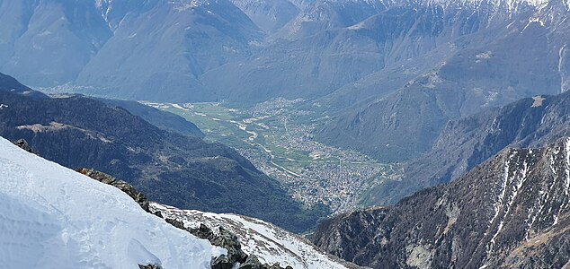
View of Chiavenna, 2774 m below

View of the Bergell Alps

Oberhalbsteiner Alps , taken from Pizz Gallagiun

Val Madris , taken from the Pizz Gallagiun


literature
- Manfred Hunziker: Club guide, Bündner Alps . Obverse. 1st edition. tape III . Verlag des SAC, 1994, ISBN 3-85902-140-0 , p. 176-180 .
- Vital Eggenberger: Ski tours Graubünden South . Verlag des SAC, 2010, ISBN 978-3-85902-301-7 , pp. 64-66 .
- National map of Switzerland, sheet 1275 Campodolcino, 1: 25,000, Federal Office of Topography, 2016 edition.
Web links
- Calculated 360 ° panorama from Pizz Gallagiun
- Tour reports on www.hikr.org
Individual evidence
- ↑ Calculated 360 ° panorama ( U. Deuschle ; information ) from Pizz Gallagiun