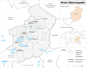
Upper Engadin district
| Upper Engadine | |
|---|---|

|
|
| Basic data | |
| Canton : | Graubünden (GR) |
| District : | Maloja |
| Main town : | Samedan |
| Surface: | 722.16 km² |
| Residents: | 16,973 December 31, 2009 |
| Population density : | 24 inhabitants per km² |
| map | |
The district Upper Engadine was, until 31 December 2015, a total of 39 districts of the canton of Grisons in Switzerland . It covered most of the Upper Engadine . Together with the Bergell district , it formed the Maloja district court and administrative district . The districts were abolished by the Graubünden regional reform. The Upper Engadin district was dissolved on December 31, 2017. From this date onwards, tasks of the district were solved by the newly formed Maloja region . The Maloja region serves the effective fulfillment of the tasks of the regional municipalities and the joint binding decision-making in regional matters. The Maloja region includes the communities of the Upper Engadine and Bergell.
Administrative division
In terms of area, the Upper Engadin district covered 722.16 km² and thus 74.17% of the total area of the Maloja district. Of the total of 18,035 inhabitants in the district, around 91.5% lived in the 11 political communities in the Upper Engadin district:
| coat of arms | Name of the parish | Population (Dec. 2009) |
Area in km² |
BFS no |
|---|---|---|---|---|
| Bever | 648 | 45.75 | 3781 | |
| Celerina / Schlarigna | 1488 | 24.02 | 3782 | |
| La Punt-Chamues-ch | 719 | 63.27 | 3785 | |
| Madulain | 202 | 16.28 | 3783 | |
| Pontresina | 2004 | 118.19 | 3784 | |
| St. Moritz | 5175 | 28.69 | 3787 | |
| Samedan | 2976 | 113.80 | 3786 | |
| S-chanf | 682 | 138.03 | 3788 | |
| Sils in the Engadin / Segl | 754 | 63.57 | 3789 | |
| Silvaplana | 1002 | 44.77 | 3790 | |
| Zuoz | 1323 | 65.79 | 3791 |
The district headquarters and administrative seat was the municipality of Samedan . District President was Gian Duri Ratti (BDP). The district president also acted as president of the commissions for the district tasks and was responsible for the administrative management of the district administration as well as the implementation of the resolutions of the district council.
history
Historically, the Upper Engadin district, like all other districts in Graubünden, came into being in 1851 as part of the complete reorganization of the canton in political, administrative and judicial terms. Geographically, the districts are the successors of the judicial communities, whose tasks and competencies were to be shared with the cantons, districts and municipalities.
The districts were self-governing bodies and constituencies for the Grand Council . They were responsible for parts of the judiciary as well as enforcement, guardianship and civil status. The Oberengadin district, with 11 of 16 municipalities in the Maloja district, was responsible for regional planning, the Oberengadin hospital, the Oberengadin retirement and nursing home, the administration of public transport and the management of the Oberengadin music school.
literature
- The municipalities of the canton of Graubünden. Chur / Zurich 2003, 2nd edition, ISBN 3-7253-0741-5 .
- Martin Bundi, Christian Rathgeb: The state constitution of Graubünden. Chur / Zurich 2003, ISBN 3-7253-0743-1 .
Individual evidence
- ↑ District constitution ( page no longer available , search in web archives ) Info: The link was automatically marked as defective. Please check the link according to the instructions and then remove this notice. (PDF; 138 kB)
