
Bergell district
| Bergell | |
|---|---|
_wappen.svg)
|
|
| Basic data | |
| Canton : | Graubünden (GR) |
| District : | Maloja |
| Main town : | Bregaglia |
| Surface: | 251.45 km² |
| Residents: | 1613 December 31, 2009 |
| Population density : | 6 inhabitants per km² |
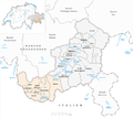
| map | |
 |
|
The Bergell district ( Circolo di Bregaglia in Italian ) was one of 39 districts in the Swiss canton of Graubünden until December 31, 2015 . It covered most of the Bergell (Val Bregaglia) . Together with the Upper Engadin district , it formed the Maloja judicial and administrative district . The districts were abolished by the Graubünden regional reform.
geography

The Bergell is the valley of the upper Mera (in the Bergell dialect Maira ) between the Malojapass ( 1815 m above sea level ) and the Lombardy Chiavenna ( 333 m above sea level ). The upper and by far the largest part of the valley belongs to the canton of Graubünden, the lower part to the Italian province of Sondrio . Below Stampa there is a castle-reinforced valley (the Porta ), which divides the valley into the two sections Sopraporta and Sottoporta . The upper section, the Sopraporta, is characterized by alpine larches and is already part of the insubric zone ; here you will find chestnut forests and later isolated palm trees . The Bergell is deeply cut between the Rhaetian Alps in the north and the Bergell Alps in the south , where three valleys flow into the Bergell: Val Forno, Val da l'Albigna and Val Bondasca.
On the other side of the watershed, Lake Sils marks the political border with the Upper Engadin district; the Loverobach near Castasegna forms the border with Italy .
coat of arms
Blazon : Black ibex striding upright in silver on a black shield base in pewter cut, red armored.
Administrative division
In terms of area, the Bergell district covered 251.45 km² and thus 25.83% of the total area of the Maloja district. The Bergell belongs to the Italian-speaking part (76% in 1990) of Graubünden and is the only area of this part that has been reformed (71% in 1990). Of the total of 18 035 inhabitants of the district, only 8.5% live in the political municipality of Bregaglia or in the Bergell district:
| coat of arms | Name of the parish | Population (December 2007) |
Area in km² |
BFS no |
|---|---|---|---|---|
| Bregaglia | 1544 | 251.45 | 3792 |
Changes in the community since 2000
Municipalities until 2009

Mergers
- 2010: Bondo , Castasegna , Soglio , Stampa and Vicosoprano → Bregaglia
In the Maloja district (Circolo di Bregaglia / Bergell district) the five former municipalities of Bondo , Castasegna , Soglio , Stampa and Vicosoprano merged on January 1, 2010 to form the only municipality of Bregaglia (Bergell), which means that the Bergell district and the Bergell municipality are now identical .
The main district and center of the valley is Vicosoprano . The communities Vicosoprano and Stampa belong to the Sopraporta ; to the Sottoporta Bondo, Castasegna and Soglio. Villa di Chiavenna and Piuro are in the national territory of Italy .
The majority of the administration is based in the Upper Engadine municipality of Samedan . The Upper Engadin district, with 11 of the 12 municipalities in the Maloja district, is responsible for regional tasks such as regional planning, the Upper Engadine hospital, the Upper Engadine retirement and nursing home and public transport.
history
Historically, the Bergell district, like all other districts in Graubünden, came into being in 1851 as part of the complete reorganization of the canton in political, administrative and judicial terms. The former Bergell High Court has been a district of the Maloja district since 1851. Geographically, the districts are considered the successors of the judicial communities; however, the tasks and competencies were to be shared with the cantons, districts and municipalities. The districts are self-governing bodies and constituencies for the Grand Council . You are responsible for parts of the jurisdiction as well as the enforcement, guardianship and civil status system.
In the last 150 years the valley has suffered from strong migration: the population decreased from 1803 with 2,170 inhabitants by 1990 to 1,434 inhabitants (1,586 in December 2007), and the once dominant agriculture lost its importance . The use of hydropower and tourism brought new jobs and financial resources - in Viscosoprano there is a power station and a substation for the city of Zurich's electricity station (EWZ), as well as the city of Zurich in the Grisons valleys, where a considerable amount of electricity is produced , provided.
literature
- Adolf Collenberg: Bergell. In: Historical Lexicon of Switzerland .
- The municipalities of the canton of Graubünden. Chur / Zurich 2003, 2nd edition, ISBN 3-7253-0741-5 .
- Martin Bundi, Christian Rathgeb: The state constitution of Graubünden. Chur / Zurich 2003, ISBN 3-7253-0743-1 .