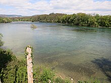
Rheinaue Rietheim
The Rheinaue Rietheim “Chly Rhy” is 35 hectares and is the largest wetland area on the Rhine in the canton of Aargau . It is located in the municipality of Rietheim on the last free, undamped stretch of the Rhine and is an important part of the Aargau floodplain protection park.
In the federal inventory of floodplain areas of national importance , it belongs to property no. 3 (1992) “Koblenz Rhine and Laufen ”. The Koblenzer Laufen has been a Swiss landscape of national importance since 1977
history
The Rhine between Bad Zurzach and Koblenz flooded useful land in the wide valley near Rietheim, destroyed seeds and fertilized the soil in a natural way. In order to prevent such flooding, the 1.5 kilometer long branch of the Chly Rhy was separated from the Rhine by a fill in the 1920s and further surrounding areas were raised. Around 1960, the Chly-Rhy estuary was raised over a large area for a planned power plant and reforested with poplar trees. The introduction of large amounts of earth material for disposal or as a drainage measure in the original river course and in other wet areas lost valuable habitats that are rare on the Rhine, such as softwood meadows, wet meadows, flood channels and sandbanks.
In 1993, a constitutional article was adopted by the voters, which obliges the canton of Aargau to build an alluvial reserve on one percent of the canton's area. In order to be able to restore these habitats at the Aue Chly Rhy, the canton of Aargau and Pro Natura have jointly acquired land. The floodplain renaturation project was mainly carried out in 2014/2015. Many embankments, solid paths and plants that were not in the same location were removed, new ponds were dug and the Chly Rhy tributary was exposed again according to old plans.
The Chly Rhy Auen observation tower offers a good overview of the floodplain. The “Koblenzer Laufen” with the only rapids left on the Upper Rhine is part of the floodplain protection park. A hiking trail with three viewing platforms on bunkers at the former Koblenz blocking point leads along the banks of the Rhine from Koblenz via “Koblenzer Laufen” to the “Chly Rhy” floodplain and on to Bad Zurzach.
Web links
- Auen Rietheim
- Leaflet Aue Chly Rhy
- Floodplains. The wild sides of the Aargau. 20 years of the floodplain protection park
- Aargauer Zeitung of May 12, 2015: Change of perspective: Here you can see the floodplain «Chly Rhy» from above
Individual evidence
- ↑ Canton Aargau: a jewel of national importance: The Aue Chly Rhy ( Memento of the original from April 5, 2017 in the Internet Archive ) Info: The archive link has been inserted automatically and has not yet been checked. Please check the original and archive link according to the instructions and then remove this notice.
- ↑ Alluvial Park Canton Aargau
- ^ Pro Natura Aargau: Aue Rietheim
Coordinates: 47 ° 36 '24 " N , 8 ° 16' 16" E ; CH1903: 662607 / two hundred and seventy-three thousand two hundred twenty-six

