Wildstrubel
| Wildstrubel | ||
|---|---|---|
|
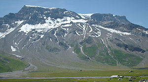
Wildstrubel from Simmental (May 2017) |
||
| height | 3244 m above sea level M. | |
| location | Canton Bern / Canton Wallis border | |
| Mountains | Bernese Alps | |
| Dominance | 8.73 km → Rinderhorn | |
| Notch height | 815 m ↓ Rawilpass | |
| Coordinates | 606 919 / 138773 | |
|
|
||
| First ascent | 1856 by Edmund von Fellenberg | |
| Normal way | Gemmipass - Lämmerenhütte - Wildstrubel Glacier - Mittler Wildstrubel - Grossstrubel | |
|
Wildstrubel and Engstligenalp from the north (July 2006) |
||

The Wildstrubel is a glaciated mountain group in the Bernese Alps in Switzerland . It lies between Lenk and Adelboden in the north and the Rhone valley in the south. A historical name for him is Breiteis . Although it is in front of the main ridge of the Bernese Alps to the north, the border between the cantons of Bern and Valais runs over it , extending northwards over the Gemmi Pass .
geography
The Wildstrubel consists of three almost equally high peaks (from west to east):
- actual Wildstrubel ( 3244 m above sea level ), also called "Lenkerstrubel"
- Middle summit ( 3243.5 m above sea level )
- Grossstrubel ( 3243 m above sea level )
The Wildstrubel slopes steeply to the west and north; on the southeast flank is the Wildstrubel Glacier , which is drained via the Lämmerenalp to the Daubensee . The extensive Glacier de la Plaine Morte lies on its southern flank .
Upstream to the northwest is the Ammertenhorn at 2,666 m above sea level. M.
The whole massif of the Wildstrubel is a karst area with no significant visible outlets. Two impressive springs arise at the foot of the massif: the Simmenquelle (s) on the Retzliberg above Lenk, as well as the Source de la Liène above the Rawilstausee in Valais, which gushes straight out of a vertical rock face like a tap .
swell
- ↑ Karl Stettler, Das Freigbuch , 1887, p. 473.
Web links
- Wildstrubel on the ETHorama platform


