
Lenk
| Lenk | |
|---|---|
 |
|
| State : |
|
| Canton : |
|
| Administrative district : | Obersimmental-Saanen |
| BFS no. : | 0792 |
| Postal code : | 3775 |
| Coordinates : | 600366 / 145074 |
| Height : | 1068 m above sea level M. |
| Height range : | 1016–3243 m above sea level M. |
| Area : | 122.96 km² |
| Residents: | 2345 (December 31, 2018) |
| Population density : | 19 inhabitants per km² |
| Website: | www.lenkgemeinde.ch |
 Lenk in the Simmental |
|
| Location of the municipality | |
  |
|
The steering (also Lenk im Simmental ), the local berneroberländischen dialect at the Lengg [ɑn dər lɛŋk] , is a municipality in the Obersimmental-Saanen the Swiss canton of Bern .
geography
Lenk is the highest municipality in the Simmental . The municipality includes several mountains, the highest is the Wildstrubel . A little below the Wildstrubels, at the Siebenbrünnen , rises the Simme , which gives the Simmental its name.
Lenk is 57 km south of Bern and 42 km east of Montreux (as the crow flies). The lowest point of the municipality is at Brändli at approx. 1016 m above sea level. M. , highest point is the Wildstrubel at 3244 m above sea level. M.
politics
The voting shares of the parties at the 2015 National Council election were: SVP 57.5%, BDP 10.2%, FDP 9.7%, SP 6.4%, EDU 4.4%, glp 3.9%, GPS 2.7 %, EVP 2.7%, CVP 0.4%.
economy
The municipality of Lenk lives mainly from tourism, namely from winter sports. There are also various agricultural and commercial enterprises. Six sawmill / carpentry companies, six truck transport companies, four carpenters, five car companies and twelve civil engineering companies are based on the Lenk. Eight architecture and real estate offices take care of the planning and sale of the objects built (as of December 2008).
history


The history of Lenk goes back to the Neolithic Age , when people climbed the 2660 m above sea level. M. used the Tierberghöhle as a resting place. It is probably the highest alpine resting place in prehistoric times.
The first documentary mention of Lenk as "an der Leng" dates back to 1370. In 1505 the five farmers Aegerten, Gutenbrunnen, Brand, Oberried and Pöschenried merged to form the parish of Lenk. Before that, Lenk belonged to the parish of St. Stephan and before that to the parish of Zweisimmen , the mother parish of the Obersimmental. A decade passed before Lenk became completely independent, in which differences with the parishes of St. Stephan and Zweisimmen as well as the Interlaken monastery had to be settled. The Reformation implemented in Bern in 1528 met with fierce resistance in the Obersimmental. Under pressure from the Catholic trading partners from Valais, the Lenkers wrote to Bern in 1529 that they wanted to keep the old faith. It was not until four years later that Lenk was reformed in 1533 under pastor Wilhelm Dachs.
1663 raged long on the steering a year plague . The epidemic, which had been rampant in the Bernese Oberland since 1358, did not appear on the Lenk until 1752 when it claimed three children's lives in the rectory.
Over the Rawilpass ( 2425 m above sea level ), the Lenkers had trade relations with the Valais since the early Middle Ages . Several meadows north of the top of the pass were maintained by the Valais for a long time. B. the Wallisdole on the Iffigenalp . The legend of the so-called Wyberschlacht on the Langermatte also points to conflicts between Lenk and Valais.
Because of the persistent flooding of the Oberried by the Simme, its stream bed was artificially changed in the 18th century. The most striking witnesses of this water correction are the Simmen Falls , where the masses of water plunge into the valley in a stream bed blasted into the rock.
The export of Simmental Fleckviehs has flourished in the Simmental since the 18th century . Breeding and sales of the coveted breed brought work and prosperity to the entire valley, as can be seen in the richly decorated Simmental houses from that time.
Due to the poor economic situation, numerous poor Lenk families emigrated to America, mainly in the 19th century. The local council supported them with 20 to 40 francs per child.
On July 16, 1878, Lenk, previously spared, was hit by a devastating village fire. 25 buildings fell victim to the flames, including the old church. Although half the village burned down, there were no injuries.
On July 4, 1930, Lenk was the victim of a severe weather disaster. After a violent thunderstorm, debris flows from the side streams devastated half the village and blocked the river bed of the Simme, so that the entire village center was flooded for a month. Only with outside help, including from the Swiss Army , could the village and access roads be repaired.
Since the Favergesee on the Plaine Morte glacier has erupted several times in the last few years and led to flooding in the Lenk, a drainage channel will be built into the glacier in 2019.
Origin of the village name
The origin of the village name cannot be determined with certainty. The most common theory says that the place name comes from the field name Lengi Egge ("long mountain ridge"), a striking ridge line that extends from the Oberlaubhorn down to the valley floor. This theory would also explain why people say “at Lenk” instead of “in Lenk” to this day.
coat of arms
The upper part of the Lenk emblem is decorated with the Siebenbrünnen , the source of the Simme , on a green background. The lower part shows Kunkel and sword on a red background and is intended to remind of the Wyberschlacht on the Langermatte at the time of the Villmerger Wars . The legend of the Wyberschlacht says that, in the absence of the men who had gone to war, the drivers of Valais cattle thieves fled the Valais armed only with tools.
tourism

With a population of just over 2,000, Lenk has around 11,000 overnight accommodations, 950 of which are hotel beds. 30 restaurants offer meals and drinks, not counting the snack stations in the ski or mountain hiking area.
The history of tourism on the Lenk began in 1689 with the opening of the Lenk mineral bath. The bath is still fed by an eight-degree cold sulfur spring from the Holiebi west of the village. The water, enriched with hydrogen sulfide , was marketed as a universal remedy, and people with various ailments came to Lenk from all over Europe in search of relief. With the advent of pharmaceuticals at the beginning of the 20th century, interest in the Lenk mineral baths waned and winter sports took on the role of the motor of tourism. The first transport line was the Funi (short for Funiculaire), a toboggan funicular that transported winter sports enthusiasts from Lenk to Stoss, roughly to where the middle station of the Lenk-Betelberg gondola is today. More railways followed on both sides of the valley. Today, in addition to the "local mountain" Betelberg, there is a lift network with the Adelboden region . The highest point is the Dossen drag lift at 2362 m above sea level. M. in the Engstligenalp area on the Adelboden side. A total of 70 lifts open up 210 kilometers of slopes. This makes the Adelboden-Lenk ski area one of the largest in the Bernese Oberland.
The old tradition of the health resort and bathing resort of Lenk has been revived in the luxury hotel Lenkerhof in a new atmosphere.
Events
The Lenk Jazz Days have taken place every July since 1988 . In addition to the concerts on Kronenplatz, there are workshops for young musicians. Bands from various countries mainly play traditional New Orleans jazz , but gospel , blues and children's concerts are also represented.
In addition to a large number of youth and military ski camps, some of which are held several times a year, an international dog sled race takes place in Lenk every February. Events for families such as children's concerts with the mouse Jimmy Flitz characterize the touristic place.
The Strubeli steam train near Lenkersee has been in operation since autumn 2011 . It is integrated into the new playground and operates in the summer months. The 10 inch (254 mm) track has become the main attraction of the playground.
The Aelplerfest, which takes place in mid-October, has been a crowd puller for many years. Cows are decorated by their owners and driven through the village in so-called “trains”.
traffic

The 2756 meter high Schnidejoch was already used as a traffic route in prehistoric times . To the north of the pass, archaeologists found an impressive abundance of tools and clothing, the oldest of which, over 6000 years old, are around 1500 years older than Ötzi .

The remains of a Roman building, which were found in 1983 on the west bank of the Iffigensee under the surface of the water, suggest that the same pass crossing was also actively used in Roman times.
In the early Middle Ages, the Schnidejoch lost its importance in favor of the lower Rawilpass , which was made accessible by the construction of a mule track . In the first half of the 18th century, a new path was blasted into the rock face above the Iffigenalp, which shortened the route from Lenk to Valais once more.
Since the beginning of the railway age, there have been several ambitions to build a railway through the Simmental into Valais. The first project was a standard-gauge railway , which should have ensured the connection of Bern to the Simplon tunnel and thus to Italy by means of two tunnels through the Stockhorn and the Wildstrubel massif . However, the steam train project was subject to the electric Lötschberg variant. In 1912, when the Zweisimmen – Lenk MOB line was inaugurated, the construction of a Rawil railway into Valais was planned, but this was never realized.
A road over the Rawilpass, or through it, had always been an issue. The first idea was a pass road to Crans-Montana with a tunnel only 1.6 km long . As part of the national road network , an ambitious project was planned at the end of the 1950s in the form of a continuation of the A6 through the Simmental to the A9 in Valais with an approx. 4 km long Rawil tunnel. Since this road would only have been passable in summer due to its high apex and would have shown a poor cost-benefit ratio, this idea was soon discarded and instead the construction of a 9.8 km long, winter-proof tunnel was planned. The controversial motorway project, however, was rejected due to fierce resistance from the Simmental population and unfavorable geological conditions on the Rawil, despite violent protests from Valais.
Others
A short sequence of Theo against the rest of the world with Marius Müller-Westernhagen was recorded at Lenk.
photos

The Iffigbach forms a high waterfall below the Iffigenalp
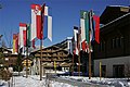
Kronenplatz on the Lenk with hotel chalets and tourist decorations

Chalet in Pöschenried, which stretches along the ridge to the Oberlaubhorn


literature
- Anne-Marie Dubler : Lenk. In: Historical Lexicon of Switzerland .
- Albert Sommer: 500 years of Lenk. Wimmis 2005.
Web links
Individual evidence
- ↑ Permanent resident population from STAT-TAB of the BfS , municipalities see also regional portraits 2020 on bfs.admin.ch, accessed on May 29, 2020
- ↑ a b Lexicon of Swiss municipality names . Edited by the Center de Dialectologie at the University of Neuchâtel under the direction of Andres Kristol. Frauenfeld / Lausanne 2005, p. 523.
- ↑ http://map.geo.admin.ch/
- ↑ Results of the municipality of Lenk. State Chancellery of the Canton of Bern, October 18, 2015, accessed on October 30, 2016 .
- ↑ Archived copy ( memento of the original from July 21, 2013 in the Internet Archive ) Info: The archive link was inserted automatically and has not yet been checked. Please check the original and archive link according to the instructions and then remove this notice.
- ↑ Ruth L. Aebi: Lenk, natural beauty in the Simmental. Aarau 1994. p. 27.
- ↑ Albert Sommer: 500 years of Lenk. Wimmis 2005. p. 127.
- ↑ Ruth L. Aebi: Lenk, natural beauty in the Simmental. Aarau 1994. p. 41
- ↑ Albert Sommer: 500 years of Lenk. Wimmis 2005. p. 134.
- ↑ Ruth L. Aebi: Lenk, natural beauty in the Simmental. Aarau 1994. p. 32.
- ↑ Albert Sommer: 500 years of Lenk. Wimmis 2005. pp. 152-159.
- ↑ The glacier lake is to be structurally tamed. In: thunertagblatt.ch . April 10, 2019, accessed May 9, 2019 .
- ↑ Hans A. Michel (Ed.): The Lenk in old time, The Lenk in the year 1799. Bern 1978. S. 5.
- ^ Albert Hafner: Between peaks and lakes - archeology in the Alpine region. In: UniPress 156/2013. P. 15.
- ↑ Heinz E. Herzig: A Roman road on the Kaltwasser Pass? Problems of the Alpine roads in Roman times. In: Stiftung Kulturförderung Lenk (Ed.): Lenk, Ten Years of the Summer University of Lenk. Wimmis 1997. pp. 19-23.
- ↑ Hans A. Michel (ed.): Die Lenk in old time, Die Lenk in 1799. Bern 1978. pp. 78–80.
- ↑ Anna Amacher Hoppler: Development of the Lötschbergbahn 1902–1913. In: Kilian T. Elsasser and Stephan Appenzeller: Pionierbahn am Lötschberg, The history of the Lötschbergbahn. Zurich 2013. pp. 58–61.
- ↑ Hans A. Michel (Ed.): The Lenk in old time, The Lenk in the year 1799. Bern 1978. P. 78.
- ↑ Albert Sommer: 500 years of Lenk. Wimmis 2005. p. 158.